P
Seller's Agent in 2013
Peter doCouto
RE/MAX


Estimated Value: $277,575 - $322,000
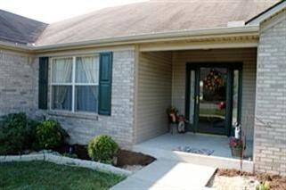
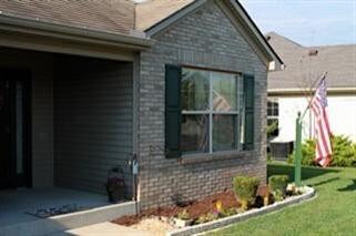
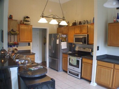
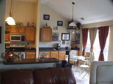
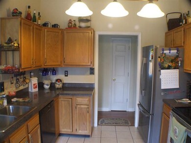
You are sure to Love and Admire this incredibly well kept, split bedroom ranch in the desirable Southbrook subdivision. Situated on a premium, privacy fenced level lot, this home has some outstanding updates! Inside you'll find a very comfortable floorplan of 3 bd and 2 bth, with new flooring in the formal dining room, a wonderfully expanded kitchen, new upgraded appliances , including double oven with convection,large well-lit rooms, comfortable Master-suite, separate utility/mud room, a state of the art, high efficiency heat-pump water heater and more! Relax outdoors in you huge Privacy-fenced yard with tremendous 2-tiered deck with swing, sitting/dining area and Like-New, high efficiency Hot Springs Hot Tub!! Great love and care has gone into this beautiful, One-Owner home. Come see it today!
Last Agent to Sell the Property
Peter doCouto
RE/MAX Elite Lexington Listed on: 10/19/2013
| Date | Buyer | Sale Price | Title Company |
|---|---|---|---|
| Tillery Scott | $145,000 | Bluegrass Land Title Llc | |
| Wilkinson Sandra | $147,000 | Bluegrass Land Title Llc |
| Date | Status | Borrower | Loan Amount |
|---|---|---|---|
| Open | Tillery Scott | $142,373 | |
| Previous Owner | Wilkinson Sandra | $139,650 |
| Date | Event | Price | List to Sale | Price per Sq Ft |
|---|---|---|---|---|
| 12/16/2013 12/16/13 | Sold | $147,000 | 0.0% | $92 / Sq Ft |
| 10/21/2013 10/21/13 | Pending | -- | -- | -- |
| 10/17/2013 10/17/13 | For Sale | $147,000 | -- | $92 / Sq Ft |
| Year | Tax Paid | Tax Assessment Tax Assessment Total Assessment is a certain percentage of the fair market value that is determined by local assessors to be the total taxable value of land and additions on the property. | Land | Improvement |
|---|---|---|---|---|
| 2024 | $2,253 | $214,200 | $37,800 | $176,400 |
| 2023 | $2,275 | $214,200 | $37,800 | $176,400 |
| 2022 | $332 | $178,500 | $31,500 | $147,000 |
| 2021 | $332 | $178,500 | $31,500 | $147,000 |
| 2020 | $332 | $178,500 | $31,500 | $147,000 |
| 2019 | $332 | $178,500 | $31,500 | $147,000 |
| 2018 | $270 | $145,000 | $30,000 | $115,000 |
| 2017 | $270 | $145,000 | $30,000 | $115,000 |
| 2016 | $1,482 | $147,000 | $30,000 | $117,000 |
| 2015 | $1,482 | $147,000 | $30,000 | $117,000 |
| 2014 | $1,457 | $147,000 | $30,000 | $117,000 |
P
Seller's Agent in 2013
Peter doCouto
RE/MAX
T
Buyer's Agent in 2013
Tammie Guy
RE/MAX
(859) 885-3229
19 in this area
65 Total Sales
Source: ImagineMLS (Bluegrass REALTORS®)
MLS Number: 1320520
APN: 059-40-01-023.00
Disclaimer: Certain information contained herein is derived from information provided by parties other than Homes.com. All information provided is deemed reliable, but is not guaranteed to be accurate and should be independently verified.
![]() The information is being provided by LBAR Multiple Listing Service. Information deemed reliable but not guaranteed. Information is provided for consumers' personal, non-commercial use, and may not be used for any purpose other than the identification of potential properties for purchase. Copyright 2025 LBAR Multiple Listing Service. All Rights Reserved.
The information is being provided by LBAR Multiple Listing Service. Information deemed reliable but not guaranteed. Information is provided for consumers' personal, non-commercial use, and may not be used for any purpose other than the identification of potential properties for purchase. Copyright 2025 LBAR Multiple Listing Service. All Rights Reserved.
