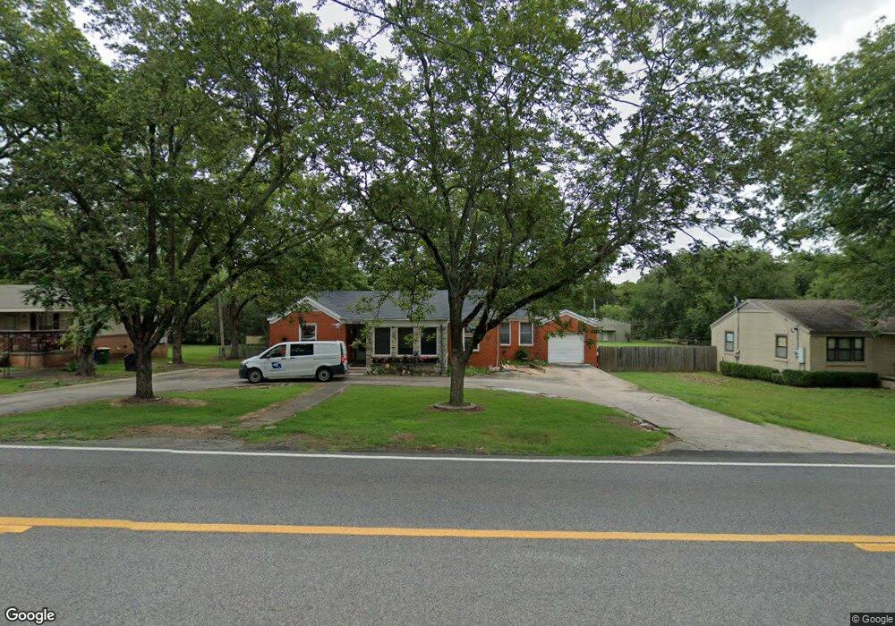
5720 Camp Robinson Rd North Little Rock, AR 72118
Amboy NeighborhoodEstimated Value: $116,000 - $145,000
--
Bed
--
Bath
9,999
Sq Ft
$13/Sq Ft
Est. Value
About This Home
This home is located at 5720 Camp Robinson Rd, North Little Rock, AR 72118 and is currently estimated at $130,746, approximately $13 per square foot. 5720 Camp Robinson Rd is a home located in Pulaski County with nearby schools including Indian Hills Elementary School, North Little Rock Middle School 6th Grade Campus, and North Little Rock High School.
Ownership History
Date
Name
Owned For
Owner Type
Purchase Details
Closed on
Feb 13, 2014
Sold by
Kweekul Blythe O and Kweekul Phosaythong
Bought by
Clark Robbie F
Current Estimated Value
Home Financials for this Owner
Home Financials are based on the most recent Mortgage that was taken out on this home.
Original Mortgage
$50,000
Interest Rate
4.55%
Mortgage Type
Future Advance Clause Open End Mortgage
Purchase Details
Closed on
Jul 31, 2000
Sold by
Vasquez German G and Vasquez Susan Le
Bought by
Kweekul Phosaythong and Kweekul Blythe O
Home Financials for this Owner
Home Financials are based on the most recent Mortgage that was taken out on this home.
Original Mortgage
$62,385
Interest Rate
8.15%
Mortgage Type
FHA
Create a Home Valuation Report for This Property
The Home Valuation Report is an in-depth analysis detailing your home's value as well as a comparison with similar homes in the area
Home Values in the Area
Average Home Value in this Area
Purchase History
| Date | Buyer | Sale Price | Title Company |
|---|---|---|---|
| Clark Robbie F | $63,000 | American Abstract & Title Co | |
| Kweekul Phosaythong | $63,000 | American Abstract & Title Co |
Source: Public Records
Mortgage History
| Date | Status | Borrower | Loan Amount |
|---|---|---|---|
| Closed | Clark Robbie F | $50,000 | |
| Previous Owner | Kweekul Phosaythong | $62,385 |
Source: Public Records
Tax History Compared to Growth
Tax History
| Year | Tax Paid | Tax Assessment Tax Assessment Total Assessment is a certain percentage of the fair market value that is determined by local assessors to be the total taxable value of land and additions on the property. | Land | Improvement |
|---|---|---|---|---|
| 2025 | $1,344 | $23,305 | $6,072 | $17,233 |
| 2024 | $1,152 | $23,305 | $6,072 | $17,233 |
| 2023 | $1,152 | $23,305 | $6,072 | $17,233 |
| 2022 | $1,055 | $23,305 | $6,072 | $17,233 |
| 2021 | $959 | $14,360 | $2,620 | $11,740 |
| 2020 | $959 | $14,360 | $2,620 | $11,740 |
| 2019 | $959 | $14,360 | $2,620 | $11,740 |
| 2018 | $959 | $14,360 | $2,620 | $11,740 |
| 2017 | $886 | $14,360 | $2,620 | $11,740 |
| 2016 | $806 | $12,060 | $2,060 | $10,000 |
| 2015 | $806 | $12,060 | $2,060 | $10,000 |
| 2014 | $806 | $15,940 | $2,060 | $13,880 |
Source: Public Records
Map
Nearby Homes
- 5732 Camp Robinson Rd
- 34 Jaynelle Place
- 9 Blackstone Cir
- 60 Oakview Dr
- 0 Timberline Dr
- 0 W Hill Ct
- 801 Green Hills Dr
- 5504 Allen St
- 813 Silver Hill Rd
- 5600 N Locust St
- 5809 N Locust St
- 901 W 58th St
- 5709 N Cedar St
- 47 Perin Rd
- 900 Donovan Briley Blvd
- 5513 N Walnut Rd
- 5315 Chandler St
- 5605 N Walnut Rd
- 6317 Rolling Hills Dr
- 6312 Rolling Hills Dr
- 5720 Camp Robinson Rd
- 5716 Camp Robinson Rd
- 5722 Camp Robinson Rd
- 101 Lindenhurst Dr
- 101 Bluebell Dr
- 5712 Camp Robinson Rd
- 100 Lindenhurst Dr
- 105 Lindenhurst Dr
- 103 Bluebell Dr
- 5730 Camp Robinson Rd
- 104 Lindenhurst Dr
- 5710 Camp Robinson Rd
- 109 Lindenhurst Dr
- 5709 Camp Robinson Rd
- 5809 Meadowbrook Ln
- 105 Bluebell Dr
- 5813 Meadowbrook Ln
- 5805 Meadowbrook Ln
- 5901 Meadowbrook Ln
- 108 Lindenhurst Dr