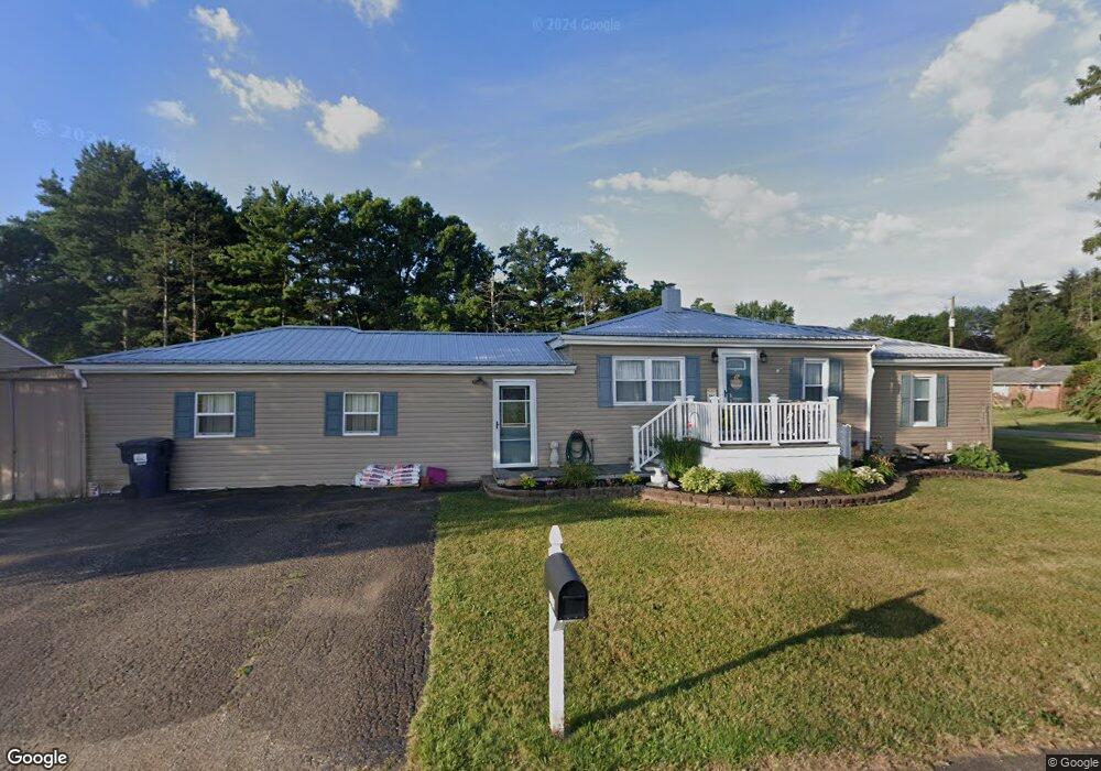
5726 Breezewood Dr NE Canton, OH 44705
East Fairmount NeighborhoodEstimated Value: $148,000 - $258,000
3
Beds
2
Baths
1,071
Sq Ft
$207/Sq Ft
Est. Value
About This Home
This home is located at 5726 Breezewood Dr NE, Canton, OH 44705 and is currently estimated at $221,463, approximately $206 per square foot. 5726 Breezewood Dr NE is a home located in Stark County with nearby schools including Charles L. Warstler Elementary School, Oakwood Middle School, and GlenOak High School.
Ownership History
Date
Name
Owned For
Owner Type
Purchase Details
Closed on
Apr 25, 2012
Sold by
Sullivan Andy H and Sullivan Stepahine M
Bought by
Sullivan Andy H and Sullivan Stepahine M
Current Estimated Value
Purchase Details
Closed on
Aug 9, 2011
Sold by
Fannie Mae
Bought by
Sullivan Andy H and Sullivan Stephanie M
Purchase Details
Closed on
Jun 30, 2011
Sold by
Eibel Roxane R
Bought by
Fannie Mae
Purchase Details
Closed on
Apr 30, 1996
Sold by
Trst John L Berger
Bought by
Eibel Daniel N and Eibel Roxane R
Home Financials for this Owner
Home Financials are based on the most recent Mortgage that was taken out on this home.
Original Mortgage
$65,000
Interest Rate
7.63%
Mortgage Type
New Conventional
Create a Home Valuation Report for This Property
The Home Valuation Report is an in-depth analysis detailing your home's value as well as a comparison with similar homes in the area
Home Values in the Area
Average Home Value in this Area
Purchase History
| Date | Buyer | Sale Price | Title Company |
|---|---|---|---|
| Sullivan Andy H | -- | None Available | |
| Sullivan Andy H | $36,000 | Ohio Title Corporation | |
| Fannie Mae | $54,000 | Attorney | |
| Eibel Daniel N | $86,500 | -- |
Source: Public Records
Mortgage History
| Date | Status | Borrower | Loan Amount |
|---|---|---|---|
| Previous Owner | Eibel Daniel N | $65,000 |
Source: Public Records
Tax History Compared to Growth
Tax History
| Year | Tax Paid | Tax Assessment Tax Assessment Total Assessment is a certain percentage of the fair market value that is determined by local assessors to be the total taxable value of land and additions on the property. | Land | Improvement |
|---|---|---|---|---|
| 2025 | -- | $84,110 | $23,350 | $60,760 |
| 2024 | -- | $84,110 | $23,350 | $60,760 |
| 2023 | $2,876 | $60,380 | $17,570 | $42,810 |
| 2022 | $2,890 | $60,380 | $17,570 | $42,810 |
| 2021 | $2,903 | $60,380 | $17,570 | $42,810 |
| 2020 | $2,774 | $52,440 | $15,160 | $37,280 |
| 2019 | $2,753 | $52,480 | $15,160 | $37,320 |
| 2018 | $2,724 | $52,480 | $15,160 | $37,320 |
| 2017 | $2,802 | $49,570 | $14,040 | $35,530 |
| 2016 | $4,890 | $40,160 | $15,650 | $24,510 |
| 2015 | $590 | $40,160 | $15,650 | $24,510 |
| 2014 | $992 | $35,920 | $14,000 | $21,920 |
| 2013 | $675 | $25,240 | $14,000 | $11,240 |
Source: Public Records
Map
Nearby Homes
- 5109 Columbus Rd NE
- 3951 Glenoak Dr NE
- 6030 Holderman Ave
- 5623 Shallow Creek Ave
- 5208 Oakridge Dr
- 5700 Birmingham Rd NE
- 0 Pilot Knob Ave NE
- 5700 Glena St
- 3788 Psolla St NE
- 2690 Crompton St NE
- 3625 Alpine St NE
- Forsythia Plan at Orchard Park - Aspire Single Family Collection
- Dayton Plan at Orchard Park - Aspire Townhome Collection
- Goldenrod Plan at Orchard Park - Aspire Single Family Collection
- Water Lily Plan at Orchard Park - Aspire Single Family Collection
- Edison Plan at Orchard Park - Aspire Townhome Collection
- Oleander Plan at Orchard Park - Aspire Single Family Collection
- Beckfield Plan at Orchard Park - Aspire Townhome Collection
- 2975 Mcintosh Dr NE
- 2974 Mcintosh Dr NE
- 5713 Breezewood Dr NE
- 5664 Breezewood Dr NE
- 5693 Breezewood Dr NE
- 5667 Breezewood Dr NE
- 5641 Breezewood Dr NE
- 5713 Bentler Ave
- 5703 Bentler Ave
- 5607 Breezewood Dr NE
- 5681 Bentler Ave
- 5657 Bentler Ave
- 5732 Bentler Ave
- 5734 Bentler Ave
- 5641 Bentler Ave
- 5726 Bentler Ave
- 5702 Bentler Ave
- 5702 Bentler Ave
- 5619 Bentler Ave
- 5750 Bentler Ave
- 5736 Bentler Ave
- 5548 Breezewood Dr NE