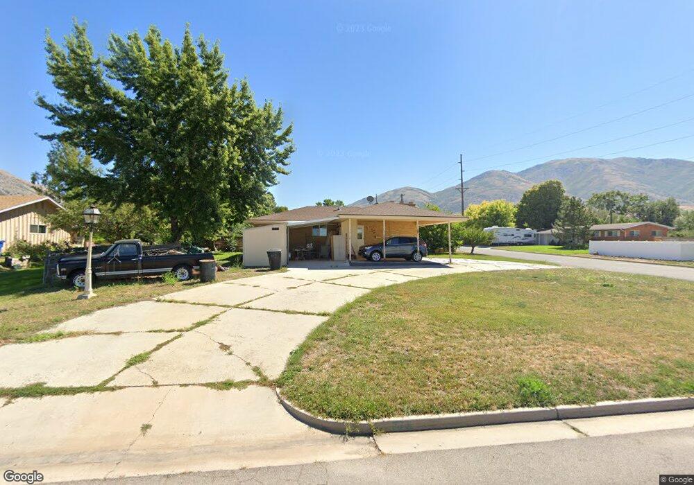
573 S 800 W Brigham City, UT 84302
Estimated Value: $365,037 - $413,000
3
Beds
1
Bath
1,204
Sq Ft
$322/Sq Ft
Est. Value
About This Home
This home is located at 573 S 800 W, Brigham City, UT 84302 and is currently estimated at $387,509, approximately $321 per square foot. 573 S 800 W is a home located in Box Elder County with nearby schools including Lake View Elementary School, Adele C. Young Intermediate School, and Box Elder Middle School.
Ownership History
Date
Name
Owned For
Owner Type
Purchase Details
Closed on
May 22, 2018
Sold by
Brown Desire and Pett April
Bought by
Barker Brent
Current Estimated Value
Purchase Details
Closed on
Nov 19, 2012
Sold by
Barker Darlene M and Barker Brent
Bought by
Barker Brent and Brown Desiree
Purchase Details
Closed on
Jul 12, 2006
Sold by
Childress Marlene D
Bought by
Woodland Michael D and Woodland Cari L
Home Financials for this Owner
Home Financials are based on the most recent Mortgage that was taken out on this home.
Original Mortgage
$118,400
Interest Rate
6.69%
Mortgage Type
New Conventional
Create a Home Valuation Report for This Property
The Home Valuation Report is an in-depth analysis detailing your home's value as well as a comparison with similar homes in the area
Home Values in the Area
Average Home Value in this Area
Purchase History
| Date | Buyer | Sale Price | Title Company |
|---|---|---|---|
| Barker Brent | -- | Phillips Hansen Land Title | |
| Barker Brent | -- | None Available | |
| Woodland Michael D | -- | First American Title Ins Co |
Source: Public Records
Mortgage History
| Date | Status | Borrower | Loan Amount |
|---|---|---|---|
| Previous Owner | Woodland Michael D | $118,400 |
Source: Public Records
Tax History Compared to Growth
Tax History
| Year | Tax Paid | Tax Assessment Tax Assessment Total Assessment is a certain percentage of the fair market value that is determined by local assessors to be the total taxable value of land and additions on the property. | Land | Improvement |
|---|---|---|---|---|
| 2025 | $1,971 | $387,159 | $105,000 | $282,159 |
| 2024 | $1,971 | $379,374 | $100,000 | $279,374 |
| 2023 | $2,070 | $408,047 | $95,000 | $313,047 |
| 2022 | $2,061 | $207,690 | $22,000 | $185,690 |
| 2021 | $1,566 | $234,651 | $40,000 | $194,651 |
| 2020 | $1,444 | $234,651 | $40,000 | $194,651 |
| 2019 | $1,350 | $116,741 | $22,000 | $94,741 |
| 2018 | $1,214 | $104,384 | $22,000 | $82,384 |
| 2017 | $1,069 | $159,080 | $16,500 | $129,080 |
| 2016 | $1,118 | $84,114 | $16,500 | $67,614 |
| 2015 | $1,035 | $77,967 | $16,500 | $61,467 |
| 2014 | $1,035 | $75,040 | $16,500 | $58,540 |
| 2013 | -- | $75,040 | $16,500 | $58,540 |
Source: Public Records
Map
Nearby Homes
- 515 S 700 W
- 1182 W 500 S
- 641 S 500 W
- 436 S 500 W
- Tourmaline Plan at Beeton Path - Seasons
- Coral Plan at Beeton Path - Seasons
- Citrine Plan at Beeton Path - Seasons
- Lapis Plan at Beeton Path - Seasons
- 562 S 300 W
- 315 S 500 W
- 946 S 800 W
- 1069 W 450 S Unit 71
- 1053 W 400 S Unit 47
- 526 W 200 S
- 1059 W 400 S Unit 46
- 1075 W 450 S Unit 70
- 1072 W 450 S
- 1072 W 450 S Unit 55
- 1081 W 450 S Unit 69
- 1078 W 450 S