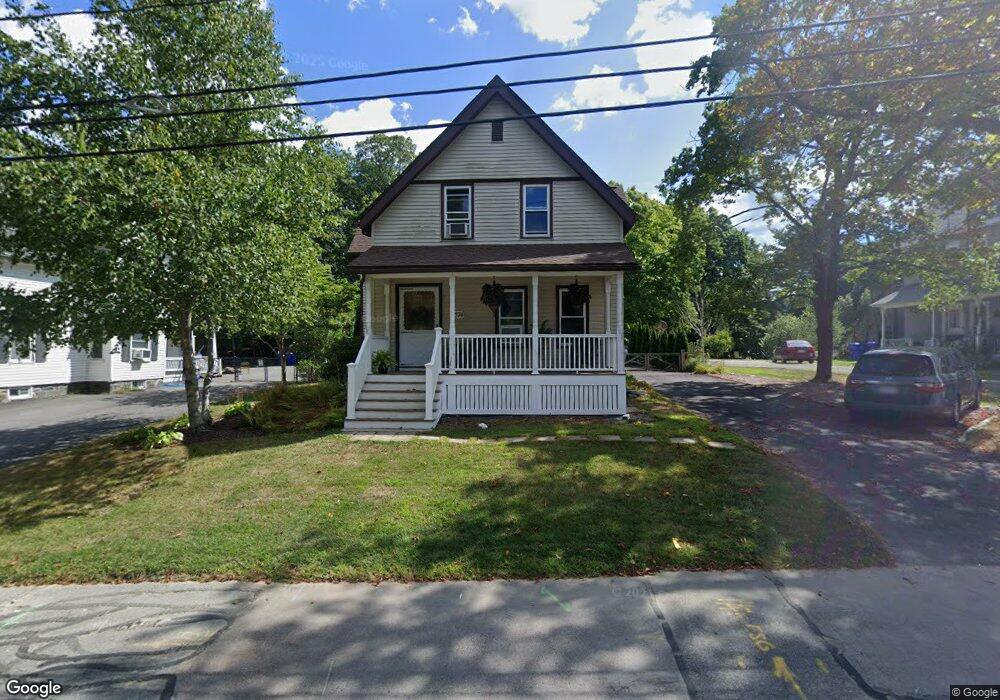
574 Cohannet St Taunton, MA 02780
Estimated Value: $449,000 - $514,000
4
Beds
2
Baths
1,579
Sq Ft
$313/Sq Ft
Est. Value
About This Home
This home is located at 574 Cohannet St, Taunton, MA 02780 and is currently estimated at $494,064, approximately $312 per square foot. 574 Cohannet St is a home located in Bristol County with nearby schools including Mulcahey Elementary School, Taunton High School, and John F. Parker Middle School.
Ownership History
Date
Name
Owned For
Owner Type
Purchase Details
Closed on
May 7, 2002
Sold by
Boiros John F and Boiros Maureen F
Bought by
Farrar Kevin C and Boiros Rachel E
Current Estimated Value
Home Financials for this Owner
Home Financials are based on the most recent Mortgage that was taken out on this home.
Original Mortgage
$152,000
Outstanding Balance
$65,086
Interest Rate
7.13%
Mortgage Type
Purchase Money Mortgage
Estimated Equity
$428,978
Create a Home Valuation Report for This Property
The Home Valuation Report is an in-depth analysis detailing your home's value as well as a comparison with similar homes in the area
Home Values in the Area
Average Home Value in this Area
Purchase History
| Date | Buyer | Sale Price | Title Company |
|---|---|---|---|
| Farrar Kevin C | $190,000 | -- |
Source: Public Records
Mortgage History
| Date | Status | Borrower | Loan Amount |
|---|---|---|---|
| Open | Farrar Kevin C | $152,000 |
Source: Public Records
Tax History Compared to Growth
Tax History
| Year | Tax Paid | Tax Assessment Tax Assessment Total Assessment is a certain percentage of the fair market value that is determined by local assessors to be the total taxable value of land and additions on the property. | Land | Improvement |
|---|---|---|---|---|
| 2025 | $4,678 | $427,600 | $144,000 | $283,600 |
| 2024 | $4,271 | $381,700 | $144,000 | $237,700 |
| 2023 | $4,305 | $357,300 | $150,600 | $206,700 |
| 2022 | $3,972 | $301,400 | $116,800 | $184,600 |
| 2021 | $3,814 | $268,600 | $106,100 | $162,500 |
| 2020 | $3,682 | $247,800 | $106,100 | $141,700 |
| 2019 | $3,622 | $229,800 | $110,200 | $119,600 |
| 2018 | $3,567 | $226,900 | $111,200 | $115,700 |
| 2017 | $3,228 | $205,500 | $105,800 | $99,700 |
| 2016 | $3,128 | $199,500 | $102,700 | $96,800 |
| 2015 | $3,079 | $205,100 | $103,900 | $101,200 |
| 2014 | $3,018 | $206,600 | $103,900 | $102,700 |
Source: Public Records
Map
Nearby Homes
- 193 Winthrop St
- 24 Highland Terrace
- 56 Silver St
- 125 Highland St Unit 103
- 132 Winthrop St
- 22 Everett St
- 72 Barnum St
- 170 Highland St Unit 320
- 39 Myrtle St
- 98 Winthrop St
- 278 Cohannet St
- 26 Kilmer Ave
- 55 Highland Ave
- 16 Clinton St
- 19 Mason St
- 63 Kilmer Ave
- 48 Oak St
- 16 Kilton St
- 46 Harrison St Unit 4
- 252 Somerset Ave
- 566 Cohannet St
- 582 Cohannet St
- 590 Cohannet St
- 556 Cohannet St
- 581 Cohannet St
- 550 Cohannet St
- 559 Cohannet St
- 551 Cohannet St
- 598 Cohannet St Unit 1B
- 598 Cohannet St Unit 3
- 598 Cohannet St
- 597 Cohannet St
- 45 Dwinell Rd
- 544 Cohannet St
- 137 Briggs St
- 545 Cohannet St
- 55 Dwinell Rd
- 532 Cohannet St
- 3 Wilmarth St
- 3 Wilmarth St Unit 1