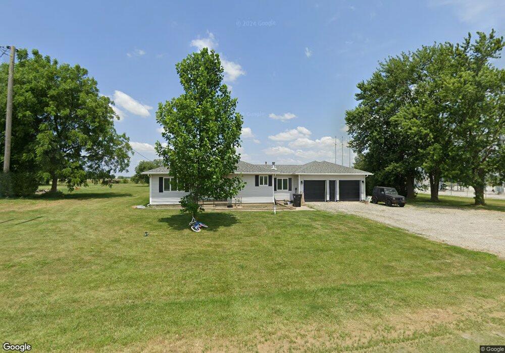
5747 W Us Highway 224 Decatur, IN 46733
Estimated Value: $128,000 - $231,000
3
Beds
2
Baths
1,576
Sq Ft
$126/Sq Ft
Est. Value
About This Home
This home is located at 5747 W Us Highway 224, Decatur, IN 46733 and is currently estimated at $198,344, approximately $125 per square foot. 5747 W Us Highway 224 is a home located in Adams County with nearby schools including Southeast Elementary School, Bellmont Elementary School, and Bellmont Middle School.
Ownership History
Date
Name
Owned For
Owner Type
Purchase Details
Closed on
Aug 10, 2020
Sold by
Werling Beverly K
Bought by
Boese Nathan S
Current Estimated Value
Home Financials for this Owner
Home Financials are based on the most recent Mortgage that was taken out on this home.
Original Mortgage
$73,150
Outstanding Balance
$64,889
Interest Rate
3%
Mortgage Type
New Conventional
Estimated Equity
$133,455
Create a Home Valuation Report for This Property
The Home Valuation Report is an in-depth analysis detailing your home's value as well as a comparison with similar homes in the area
Home Values in the Area
Average Home Value in this Area
Purchase History
| Date | Buyer | Sale Price | Title Company |
|---|---|---|---|
| Boese Nathan S | -- | None Available |
Source: Public Records
Mortgage History
| Date | Status | Borrower | Loan Amount |
|---|---|---|---|
| Open | Boese Nathan S | $73,150 |
Source: Public Records
Tax History Compared to Growth
Tax History
| Year | Tax Paid | Tax Assessment Tax Assessment Total Assessment is a certain percentage of the fair market value that is determined by local assessors to be the total taxable value of land and additions on the property. | Land | Improvement |
|---|---|---|---|---|
| 2024 | $1,004 | $149,200 | $25,900 | $123,300 |
| 2023 | $914 | $139,500 | $25,900 | $113,600 |
| 2022 | $866 | $137,600 | $25,900 | $111,700 |
| 2021 | $780 | $127,100 | $22,900 | $104,200 |
| 2020 | $690 | $121,000 | $22,900 | $98,100 |
| 2019 | $1,718 | $111,700 | $22,900 | $88,800 |
| 2018 | $1,773 | $107,800 | $22,900 | $84,900 |
| 2017 | $1,730 | $105,900 | $21,900 | $84,000 |
| 2016 | $1,623 | $103,500 | $21,900 | $81,600 |
| 2014 | $1,406 | $98,500 | $21,900 | $76,600 |
| 2013 | $1,752 | $97,800 | $21,900 | $75,900 |
Source: Public Records
Map
Nearby Homes
- 6010 N 600 W
- 5020 N 400 W
- 3803 U S 224
- 6068 N West St
- 7805 N 600 E
- 3260 N 200 W
- 2591 Hogans Alley
- 2593 Hogans Alley
- 1031 Palmer's Pass
- 2541 Hogans Alley
- 4035 E 800 N
- 11063 N 700 E
- 1705 W Monroe St
- 1137 Southampton Dr
- 115 N 11th St
- 1310 Mix Ave
- 109 N 10th St
- 1024 Adams St
- 922 W Monroe St
- 314 N 9th St
- 5747 U S 224
- 5765 W Us Highway 224
- 5807 W Us Highway 224
- 5815 W Us Highway 224
- 5833 W Us Highway 224
- 5845 W Us Highway 224
- 5861 W Us Highway 224
- 5875 W Us Highway 224
- 5895 W Us Highway 224
- 5909 W Us Highway 224
- 5921 W Us Highway 224
- 5933 W Us Highway 224
- 5965 W Us Highway 224
- 6031 N 600 W
- 5991 N 600 W
- 6055 N 600 W
- 5982 W Us Highway 224
- 5981 W Us Highway 224
- 5351 W Us Highway 224
- 6050 N 600 W