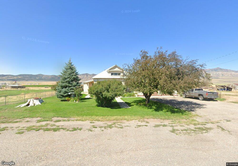
575 N State St Scipio, UT 84656
Estimated Value: $324,000 - $399,000
--
Bed
--
Bath
--
Sq Ft
3.07
Acres
About This Home
This home is located at 575 N State St, Scipio, UT 84656 and is currently estimated at $358,474. 575 N State St is a home.
Ownership History
Date
Name
Owned For
Owner Type
Purchase Details
Closed on
Jan 12, 2016
Sold by
Memmott Kevin C and Memmott Lujean
Bought by
Memmott Revocable Trust
Current Estimated Value
Purchase Details
Closed on
Aug 25, 2011
Sold by
Memmott K Chan and Memmott Lujean
Bought by
Memmott Kevin C and Memmott Lujean
Home Financials for this Owner
Home Financials are based on the most recent Mortgage that was taken out on this home.
Original Mortgage
$96,800
Interest Rate
4.48%
Mortgage Type
New Conventional
Create a Home Valuation Report for This Property
The Home Valuation Report is an in-depth analysis detailing your home's value as well as a comparison with similar homes in the area
Home Values in the Area
Average Home Value in this Area
Purchase History
| Date | Buyer | Sale Price | Title Company |
|---|---|---|---|
| Memmott Revocable Trust | -- | -- | |
| Memmott Kevin C | -- | -- |
Source: Public Records
Mortgage History
| Date | Status | Borrower | Loan Amount |
|---|---|---|---|
| Previous Owner | Memmott Kevin C | $96,800 |
Source: Public Records
Tax History Compared to Growth
Tax History
| Year | Tax Paid | Tax Assessment Tax Assessment Total Assessment is a certain percentage of the fair market value that is determined by local assessors to be the total taxable value of land and additions on the property. | Land | Improvement |
|---|---|---|---|---|
| 2025 | $1,652 | $210,785 | $30,024 | $180,761 |
| 2024 | $1,652 | $199,296 | $26,596 | $172,700 |
| 2023 | $1,884 | $199,296 | $26,596 | $172,700 |
| 2022 | $1,400 | $128,444 | $26,597 | $101,847 |
| 2021 | $1,044 | $91,862 | $19,935 | $71,927 |
| 2020 | $928 | $82,255 | $17,454 | $64,801 |
| 2019 | $843 | $75,010 | $17,469 | $57,541 |
| 2018 | $825 | $75,124 | $17,583 | $57,541 |
| 2017 | $863 | $75,138 | $17,597 | $57,541 |
| 2016 | $596 | $53,949 | $13,472 | $40,477 |
| 2015 | $596 | $53,949 | $12,375 | $41,574 |
| 2014 | -- | $54,007 | $12,375 | $41,632 |
| 2013 | -- | $54,077 | $12,375 | $41,702 |
Source: Public Records
Map
Nearby Homes
- 85 E 200 Rd N
- 7 N 200 W
- 2000 N 500 W
- 9155 Red Canyon Rd Unit 15
- 13051 Red Canyon Rd Unit 3
- 9160 Red Canyon Rd Unit 5
- 700 W 1100 S
- 8300 N 3300 E
- Mecham Rd
- 445 S Main St
- 290 N 200 Rd E
- Parcel 4609 4609x1 4609x2
- 66 W 100 S
- 26 N Mount Baldy Estates Rd Unit 26
- 117 E 300 S
- 36 W 100 S
- 155 S 200 W
- 420 W 350 N
- 80 N 400 W
- 165 E Center
- 595 N State St
- 545 N State St
- 500 N State St
- 540 N State St
- 600 N State St Unit 7
- 600 N State St Unit 8
- 600 N State St Unit 2
- 600 N State St Unit 4
- 600 N State St Unit 1
- 600 N State St Unit 6
- 600 N State St Unit 3
- 600 N State St Unit 5
- 600 N State St
- 525 N State St
- 506 N State St
- 65 E 500 N
- 70 W 500 N
- 710 N 100 E
- 85 E 500 Rd N
- 510 N 100 E