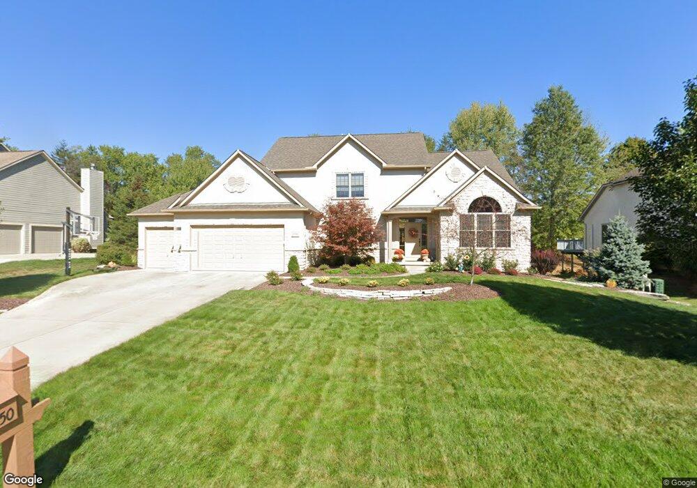
5750 Rocky Shore Dr Lewis Center, OH 43035
Orange NeighborhoodEstimated Value: $686,000 - $736,301
4
Beds
4
Baths
3,276
Sq Ft
$220/Sq Ft
Est. Value
About This Home
This home is located at 5750 Rocky Shore Dr, Lewis Center, OH 43035 and is currently estimated at $719,825, approximately $219 per square foot. 5750 Rocky Shore Dr is a home located in Delaware County with nearby schools including Alum Creek Elementary School, Olentangy Shanahan Middle School, and Olentangy High School.
Ownership History
Date
Name
Owned For
Owner Type
Purchase Details
Closed on
Oct 16, 2003
Sold by
Musgrave Construction Co Inc
Bought by
Mowrey Kent A and Mowrey Cynthia P
Current Estimated Value
Home Financials for this Owner
Home Financials are based on the most recent Mortgage that was taken out on this home.
Original Mortgage
$270,000
Outstanding Balance
$128,413
Interest Rate
6.49%
Mortgage Type
Purchase Money Mortgage
Estimated Equity
$591,412
Purchase Details
Closed on
Mar 21, 2003
Sold by
Evergreen Land Co
Bought by
Musgrave Construction Co Inc
Home Financials for this Owner
Home Financials are based on the most recent Mortgage that was taken out on this home.
Original Mortgage
$300,000
Interest Rate
5.96%
Mortgage Type
Purchase Money Mortgage
Create a Home Valuation Report for This Property
The Home Valuation Report is an in-depth analysis detailing your home's value as well as a comparison with similar homes in the area
Home Values in the Area
Average Home Value in this Area
Purchase History
| Date | Buyer | Sale Price | Title Company |
|---|---|---|---|
| Mowrey Kent A | $392,300 | Assurance Title Agency | |
| Musgrave Construction Co Inc | $78,000 | Assurance Title Agency |
Source: Public Records
Mortgage History
| Date | Status | Borrower | Loan Amount |
|---|---|---|---|
| Open | Mowrey Kent A | $270,000 | |
| Previous Owner | Musgrave Construction Co Inc | $300,000 |
Source: Public Records
Tax History Compared to Growth
Tax History
| Year | Tax Paid | Tax Assessment Tax Assessment Total Assessment is a certain percentage of the fair market value that is determined by local assessors to be the total taxable value of land and additions on the property. | Land | Improvement |
|---|---|---|---|---|
| 2024 | $11,894 | $214,980 | $40,850 | $174,130 |
| 2023 | $11,937 | $214,980 | $40,850 | $174,130 |
| 2022 | $11,769 | $172,380 | $28,320 | $144,060 |
| 2021 | $11,836 | $172,380 | $28,320 | $144,060 |
| 2020 | $11,892 | $172,380 | $28,320 | $144,060 |
| 2019 | $10,602 | $159,290 | $28,320 | $130,970 |
| 2018 | $10,650 | $159,290 | $28,320 | $130,970 |
| 2017 | $10,533 | $138,260 | $25,240 | $113,020 |
| 2016 | $9,841 | $138,260 | $25,240 | $113,020 |
| 2015 | $8,966 | $138,260 | $25,240 | $113,020 |
| 2014 | $9,094 | $138,260 | $25,240 | $113,020 |
| 2013 | $9,304 | $138,260 | $25,240 | $113,020 |
Source: Public Records
Map
Nearby Homes
- 2868 Lewis Center Rd
- 2946 Lewis Center Rd
- 5669 Maplewood Ct
- 2567 Carmel Dr
- 5491 Sandy Dr
- 2948 Prairie Dr
- 2840 Waukeegan Ave
- 3177 Shoreline Dr
- 2070 Alum Village Dr
- 6440 Morningside Dr
- 2241 Red Oak St
- 5737 Butternut Dr
- 5450 Maple Dr
- 6566 Morningside Dr
- 3175 Briarwood Ln
- 5390 Maple Dr
- 3290 Briarwood Ln
- 3186 Briarwood Ln
- 3277 Briarwood Ln
- 1929 Rocklake Ct
- 5732 Rocky Shore Dr
- 5768 Rocky Shore Dr
- 5714 Rocky Shore Dr
- 5782 Rocky Shore Dr
- 5745 Rocky Shore Dr
- 5771 Rocky Shore Dr
- 5727 Rocky Shore Dr
- 2855 Seaway Ct
- 5696 Rocky Shore Dr
- 5707 Rocky Shore Dr
- 5801 Rocky Shore Dr
- 2830 Lewis Center Rd
- 2875 Seaway Ct
- 5682 Rocky Shore Dr
- 5808 Rocky Shore Dr
- 5675 Rocky Shore Dr
- 1942 Parklawn Dr
- 5831 Rocky Shore Dr
- 1938 Parklawn Dr
- 2876 Seaway Ct