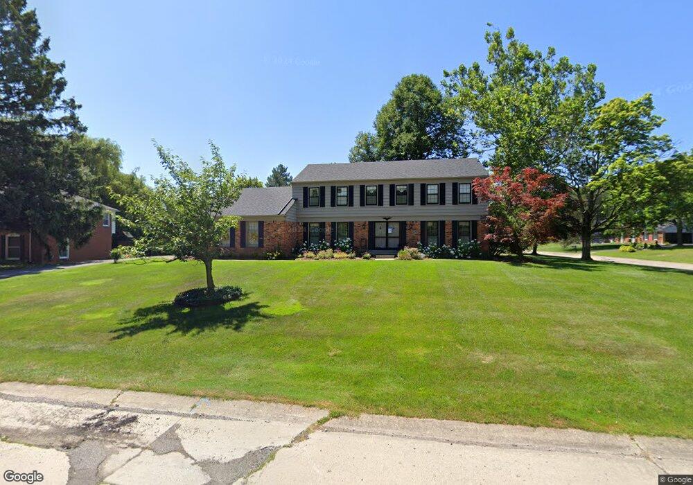
5755 Fox Hunt Ln West Bloomfield, MI 48322
Estimated Value: $424,000 - $483,000
4
Beds
3
Baths
2,664
Sq Ft
$166/Sq Ft
Est. Value
About This Home
This home is located at 5755 Fox Hunt Ln, West Bloomfield, MI 48322 and is currently estimated at $442,024, approximately $165 per square foot. 5755 Fox Hunt Ln is a home located in Oakland County with nearby schools including Sheiko Elementary School, The Susan And Rabbi Harold Loss Ecc, and Brookfield Academy - West Bloomfield.
Ownership History
Date
Name
Owned For
Owner Type
Purchase Details
Closed on
Nov 18, 2022
Sold by
Kuthy Douglas E and Kuthy Paula M
Bought by
Kuthy Family Living Trust
Current Estimated Value
Purchase Details
Closed on
Jun 26, 1998
Sold by
Taylor Trust
Bought by
Kuthy Douglas E
Home Financials for this Owner
Home Financials are based on the most recent Mortgage that was taken out on this home.
Original Mortgage
$184,000
Interest Rate
7.02%
Purchase Details
Closed on
Apr 8, 1997
Sold by
Taylor Morton G
Bought by
Morton G Taylor Tr
Create a Home Valuation Report for This Property
The Home Valuation Report is an in-depth analysis detailing your home's value as well as a comparison with similar homes in the area
Home Values in the Area
Average Home Value in this Area
Purchase History
| Date | Buyer | Sale Price | Title Company |
|---|---|---|---|
| Kuthy Family Living Trust | -- | -- | |
| Kuthy Douglas E | -- | -- | |
| Morton G Taylor Tr | -- | -- |
Source: Public Records
Mortgage History
| Date | Status | Borrower | Loan Amount |
|---|---|---|---|
| Previous Owner | Kuthy Douglas E | $184,000 |
Source: Public Records
Tax History
| Year | Tax Paid | Tax Assessment Tax Assessment Total Assessment is a certain percentage of the fair market value that is determined by local assessors to be the total taxable value of land and additions on the property. | Land | Improvement |
|---|---|---|---|---|
| 2025 | $4,348 | $198,400 | $60,750 | $137,650 |
| 2024 | $2,709 | $177,810 | $0 | $0 |
| 2022 | $2,587 | $156,480 | $45,000 | $111,480 |
| 2021 | $3,931 | $145,040 | $0 | $0 |
| 2020 | $2,535 | $142,330 | $40,550 | $101,780 |
| 2018 | $3,790 | $131,840 | $28,700 | $103,140 |
| 2015 | -- | $109,270 | $0 | $0 |
| 2014 | -- | $99,220 | $0 | $0 |
| 2011 | -- | $87,180 | $0 | $0 |
Source: Public Records
Map
Nearby Homes
- 5865 Dunmore Ct
- 5731 Farmington Rd
- 6076 Dunmore Dr
- 4819 Thorntree Dr
- 4817 Faircourt Dr
- 5608 Pembrooke Crossing
- 4205 Pinehurst Dr
- 4117 Marlwood Dr
- 6322 Pepper Hill St Unit 62
- 3865 Stonecrest Rd
- 6151 Orchard Lake Rd Unit 103
- 5585 Culpepper Dr
- 6260 Nicholas Dr
- 5352 W Doherty Dr
- 6323 Potomac Cir Unit 22
- 5292 Pond Bluff Dr
- 5596 Beauchamp
- 6610 Fieldstone Ct
- 6622 Fieldstone Ct
- 6651 Hearthside Ct Unit 1
- 5873 Trotter Ln
- 5745 Fox Hunt Ln
- 5827 Trotter Ln
- 5900 Barnstable Ct
- 5854 Trotter Ln
- 5742 Fox Hunt Ln
- 5891 Trotter Ln
- 5872 Trotter Ln
- 5836 Trotter Ln
- 5735 Fox Hunt Ln
- 5901 Barnstable Ct
- 5890 Trotter Ln
- 5728 Fox Hunt Ln
- 5818 Trotter Ln
- 5801 Trotter Ln
- 5918 Barnstable Ct
- 5909 Trotter Ln
- 5725 Fox Hunt Ln
- 5729 Shaun Rd
- 5908 Trotter Ln
Your Personal Tour Guide
Ask me questions while you tour the home.