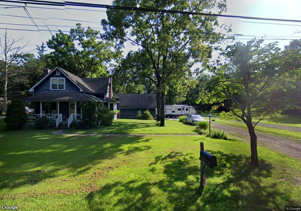
5768 Laurel St Mays Landing, NJ 08330
Estimated Value: $310,000 - $335,000
3
Beds
2
Baths
1,194
Sq Ft
$268/Sq Ft
Est. Value
About This Home
This home is located at 5768 Laurel St, Mays Landing, NJ 08330 and is currently estimated at $319,578, approximately $267 per square foot. 5768 Laurel St is a home located in Atlantic County with nearby schools including Joseph Shaner School, George L. Hess Educational Complex, and William Davies Middle School.
Ownership History
Date
Name
Owned For
Owner Type
Purchase Details
Closed on
Jun 25, 2009
Sold by
King John M and King Sarah E
Bought by
Seebeck Kenneth Allan and Dean Seebeck Marisa
Current Estimated Value
Home Financials for this Owner
Home Financials are based on the most recent Mortgage that was taken out on this home.
Original Mortgage
$245,160
Outstanding Balance
$156,889
Interest Rate
4.93%
Mortgage Type
VA
Estimated Equity
$162,689
Purchase Details
Closed on
Dec 29, 2003
Sold by
Schroer Thomas J and Schroer Susan
Bought by
King John M and King Sarah E
Home Financials for this Owner
Home Financials are based on the most recent Mortgage that was taken out on this home.
Original Mortgage
$29,250
Interest Rate
5.86%
Mortgage Type
Stand Alone Second
Create a Home Valuation Report for This Property
The Home Valuation Report is an in-depth analysis detailing your home's value as well as a comparison with similar homes in the area
Home Values in the Area
Average Home Value in this Area
Purchase History
| Date | Buyer | Sale Price | Title Company |
|---|---|---|---|
| Seebeck Kenneth Allan | $240,000 | Surety Title Corporation | |
| King John M | $195,000 | Fidelity National Title |
Source: Public Records
Mortgage History
| Date | Status | Borrower | Loan Amount |
|---|---|---|---|
| Open | Seebeck Kenneth Allan | $245,160 | |
| Previous Owner | King John M | $29,250 | |
| Previous Owner | King John M | $156,000 |
Source: Public Records
Tax History Compared to Growth
Tax History
| Year | Tax Paid | Tax Assessment Tax Assessment Total Assessment is a certain percentage of the fair market value that is determined by local assessors to be the total taxable value of land and additions on the property. | Land | Improvement |
|---|---|---|---|---|
| 2025 | $5,349 | $155,900 | $39,800 | $116,100 |
| 2024 | $5,349 | $155,900 | $39,800 | $116,100 |
| 2023 | $5,029 | $155,900 | $39,800 | $116,100 |
| 2022 | $5,029 | $155,900 | $39,800 | $116,100 |
| 2021 | $5,018 | $155,900 | $39,800 | $116,100 |
| 2020 | $5,018 | $155,900 | $39,800 | $116,100 |
| 2019 | $5,031 | $155,900 | $39,800 | $116,100 |
| 2018 | $4,855 | $155,900 | $39,800 | $116,100 |
| 2017 | $4,778 | $155,900 | $39,800 | $116,100 |
| 2016 | $4,644 | $155,900 | $39,800 | $116,100 |
| 2015 | $4,487 | $155,900 | $39,800 | $116,100 |
| 2014 | $4,427 | $168,500 | $44,700 | $123,800 |
Source: Public Records
Map
Nearby Homes
- 5780 Laurel St
- 00000 Laurel St
- 2702 Cleveland Ave
- 5781 Laurel St
- 5744 Laurel St
- 5756 Laurel St
- 5812 Laurel St
- 5811 Laurel St
- 2720 Cleveland Ave
- 5828 Laurel St
- 5941 Laurel St
- 5825 Laurel St
- 5714 Laurel St
- 14 Stone Walk
- 5709 Laurel St
- 5842 Laurel St
- 5841 Laurel St
- 5677 Laurel St
- lt 1 blk 263 Cleveland Ave
- 5698 Laurel St