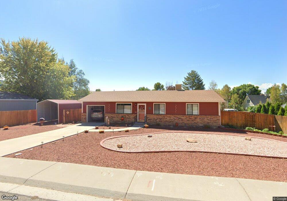
577 Rosa St Palisade, CO 81526
Palisade Area NeighborhoodEstimated Value: $388,000 - $442,000
3
Beds
2
Baths
1,000
Sq Ft
$411/Sq Ft
Est. Value
About This Home
This home is located at 577 Rosa St, Palisade, CO 81526 and is currently estimated at $410,928, approximately $410 per square foot. 577 Rosa St is a home located in Mesa County with nearby schools including Taylor Elementary School, Mount Garfield Middle School, and Palisade High School.
Ownership History
Date
Name
Owned For
Owner Type
Purchase Details
Closed on
Oct 1, 2007
Sold by
Hart Debra L and Hart Lloyd A
Bought by
Wangsnes Lisa L
Current Estimated Value
Purchase Details
Closed on
Jul 20, 2006
Sold by
Wanzer Lila M
Bought by
Hart Debra L and Hart Lloyd A
Home Financials for this Owner
Home Financials are based on the most recent Mortgage that was taken out on this home.
Original Mortgage
$117,600
Interest Rate
6.6%
Mortgage Type
Unknown
Purchase Details
Closed on
Nov 8, 1991
Sold by
Farmers Home Builders Inc
Bought by
Wangsnes Lisa L
Purchase Details
Closed on
Oct 29, 1991
Sold by
Farmers Home Builders Inc
Bought by
Wangsnes Lisa L
Purchase Details
Closed on
Jul 25, 1991
Sold by
Anderson Everett A
Bought by
Wangsnes Lisa L
Create a Home Valuation Report for This Property
The Home Valuation Report is an in-depth analysis detailing your home's value as well as a comparison with similar homes in the area
Home Values in the Area
Average Home Value in this Area
Purchase History
| Date | Buyer | Sale Price | Title Company |
|---|---|---|---|
| Wangsnes Lisa L | $202,500 | Land Title Guarantee Company | |
| Hart Debra L | $147,000 | Stewart Title Of Colorado Gr | |
| Wangsnes Lisa L | $55,000 | -- | |
| Wangsnes Lisa L | -- | -- | |
| Wangsnes Lisa L | $5,000 | -- |
Source: Public Records
Mortgage History
| Date | Status | Borrower | Loan Amount |
|---|---|---|---|
| Previous Owner | Hart Debra L | $117,600 |
Source: Public Records
Tax History Compared to Growth
Tax History
| Year | Tax Paid | Tax Assessment Tax Assessment Total Assessment is a certain percentage of the fair market value that is determined by local assessors to be the total taxable value of land and additions on the property. | Land | Improvement |
|---|---|---|---|---|
| 2024 | $1,034 | $19,030 | $6,170 | $12,860 |
| 2023 | $1,034 | $19,030 | $6,170 | $12,860 |
| 2022 | $606 | $13,760 | $4,170 | $9,590 |
| 2021 | $609 | $14,150 | $4,290 | $9,860 |
| 2020 | $568 | $13,630 | $3,930 | $9,700 |
| 2019 | $1,050 | $13,630 | $3,930 | $9,700 |
| 2018 | $978 | $11,750 | $3,240 | $8,510 |
| 2017 | $975 | $11,750 | $3,240 | $8,510 |
| 2016 | $871 | $11,680 | $3,180 | $8,500 |
| 2015 | $880 | $11,680 | $3,180 | $8,500 |
| 2014 | $755 | $10,040 | $3,580 | $6,460 |
Source: Public Records
Map
Nearby Homes
- 577 Cicero Dr
- 490 Wine Valley Rd
- 512 Crawford Ln
- 532 Crawford Ln
- 548 Crawford Ln
- 602 Elberta Ave
- 537 Crawford Ln
- 416 W 5th St
- 379 W 5th St
- 122 W 5th St
- 131 N Bower Ave Unit 48
- 139 W 6th St
- 172 E 4th St
- 131 Aspinall Dr
- 828 Logan Ct
- 829 Logan St
- 846 Cabernet Dr
- 164 Davis Cir
- 101 W 8th St
- 819 Elberta Ave