Estimated Value: $265,000 - $559,258
3
Beds
2
Baths
2,396
Sq Ft
$150/Sq Ft
Est. Value
About This Home
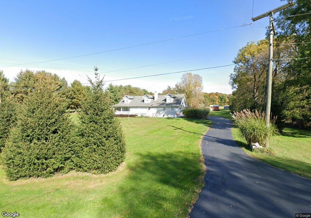
This home is located at 5775 S Fork Rd, Heath, OH 43056 and is currently estimated at $359,315, approximately $149 per square foot. 5775 S Fork Rd is a home located in Licking County with nearby schools including Jackson Intermediate School, Lakewood Middle School, and Lakewood High School.
Ownership History
Date
Name
Owned For
Owner Type
Purchase Details
Closed on
Aug 3, 2023
Sold by
Reeves Howard L and Reeves Rosanna J
Bought by
Reeves Howard L and Reeves Rosanna J
Current Estimated Value
Purchase Details
Closed on
Jul 26, 2013
Sold by
Smith Bradley H and Smith Carol Lynn
Bought by
Reeves Howard L and Reeves Roseanne J
Home Financials for this Owner
Home Financials are based on the most recent Mortgage that was taken out on this home.
Original Mortgage
$100,000
Interest Rate
3.93%
Mortgage Type
Unknown
Purchase Details
Closed on
Sep 8, 1994
Sold by
Irene E Smithers Est
Bought by
Smith Bradley H and Smith Carol
Home Financials for this Owner
Home Financials are based on the most recent Mortgage that was taken out on this home.
Original Mortgage
$76,400
Interest Rate
8.65%
Mortgage Type
New Conventional
Create a Home Valuation Report for This Property
The Home Valuation Report is an in-depth analysis detailing your home's value as well as a comparison with similar homes in the area
Purchase History
| Date | Buyer | Sale Price | Title Company |
|---|---|---|---|
| Reeves Howard L | -- | None Listed On Document | |
| Reeves Howard L | $128,000 | Chicago Title | |
| Smith Bradley H | $95,500 | -- |
Source: Public Records
Mortgage History
| Date | Status | Borrower | Loan Amount |
|---|---|---|---|
| Previous Owner | Reeves Howard L | $100,000 | |
| Previous Owner | Smith Bradley H | $76,400 |
Source: Public Records
Tax History
| Year | Tax Paid | Tax Assessment Tax Assessment Total Assessment is a certain percentage of the fair market value that is determined by local assessors to be the total taxable value of land and additions on the property. | Land | Improvement |
|---|---|---|---|---|
| 2024 | $4,654 | $132,790 | $50,400 | $82,390 |
| 2023 | $4,693 | $132,790 | $50,400 | $82,390 |
| 2022 | $3,921 | $97,760 | $36,120 | $61,640 |
| 2021 | $4,043 | $97,760 | $36,120 | $61,640 |
| 2020 | $4,056 | $97,760 | $36,120 | $61,640 |
| 2019 | $3,425 | $79,420 | $30,100 | $49,320 |
| 2018 | $3,462 | $0 | $0 | $0 |
| 2017 | $3,461 | $0 | $0 | $0 |
| 2016 | $2,874 | $0 | $0 | $0 |
| 2015 | $2,700 | $0 | $0 | $0 |
| 2014 | $3,472 | $0 | $0 | $0 |
| 2013 | $2,264 | $0 | $0 | $0 |
Source: Public Records
Map
Nearby Homes
- 307 Nicholas Dr Unit 46
- 92 Jonathan Dr
- 1285 Bluejack Ln
- 105 Clark Ave
- 1265 Green Valley Dr
- 381 Laurel Oaks Ln
- 399 Laurel Oaks Ln Unit Lot 131
- 602 Deanna Stroll Rd
- 403 Laurel Oaks Ln Unit Lot 132
- 625 Fulla Ln SE
- 164 Licking View Dr
- 944 Fieldson Dr
- 1094 Aldine Dr
- 14 Wesley Ave
- 6281 Davis Dr
- 2453 Ryan Rd
- 780 Fieldson Dr
- 233 Wildwood Ct Unit 233C
- 645 Kensington Dr Unit 645
- 225 Pleasant Lee Dr
- 5750 S Fork Rd
- 5691 S Fork Rd
- 5766 S Fork Rd
- 5624 S Fork Rd
- 5787 S Fork Rd
- 5896 S Fork Rd
- 5887 S Fork Rd
- Lot 22 S Fork Rd
- Lot 20 S Fork Rd
- Lot 21 S Fork Rd
- 0 S Fork Rd
- 5552 S Fork Rd
- 5951 S Fork Rd
- 5960 S Fork Rd
- 5523 S Fork Rd
- 5542 S Fork Rd
- 5975 S Fork Rd
- 5793 S Fork Rd
- 5521 S Fork Rd
- 5211 White Chapel Rd
Your Personal Tour Guide
Ask me questions while you tour the home.