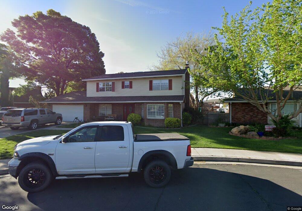
578 Cambridge Dr Saint George, UT 84770
Estimated Value: $650,000 - $782,000
6
Beds
4
Baths
2,916
Sq Ft
$239/Sq Ft
Est. Value
About This Home
This home is located at 578 Cambridge Dr, Saint George, UT 84770 and is currently estimated at $697,156, approximately $239 per square foot. 578 Cambridge Dr is a home located in Washington County with nearby schools including Legacy School, Dixie Middle School, and Dixie Intermediate School.
Ownership History
Date
Name
Owned For
Owner Type
Purchase Details
Closed on
May 17, 2012
Sold by
Rogers Mitzie T
Bought by
Porter Scott and Porter Lisa
Current Estimated Value
Home Financials for this Owner
Home Financials are based on the most recent Mortgage that was taken out on this home.
Original Mortgage
$284,696
Outstanding Balance
$196,788
Interest Rate
3.85%
Mortgage Type
FHA
Estimated Equity
$500,368
Purchase Details
Closed on
Oct 25, 2005
Sold by
Rogers Mitzie T
Bought by
Rogers Mitzie T and Mitzie T Rogers Revocable Trust
Create a Home Valuation Report for This Property
The Home Valuation Report is an in-depth analysis detailing your home's value as well as a comparison with similar homes in the area
Home Values in the Area
Average Home Value in this Area
Purchase History
| Date | Buyer | Sale Price | Title Company |
|---|---|---|---|
| Porter Scott | -- | Southern Utah Title | |
| Rogers Mitzie T | -- | First American Title Co | |
| Rogers Mitzle T | -- | First American Title Co |
Source: Public Records
Mortgage History
| Date | Status | Borrower | Loan Amount |
|---|---|---|---|
| Open | Porter Scott | $284,696 |
Source: Public Records
Tax History Compared to Growth
Tax History
| Year | Tax Paid | Tax Assessment Tax Assessment Total Assessment is a certain percentage of the fair market value that is determined by local assessors to be the total taxable value of land and additions on the property. | Land | Improvement |
|---|---|---|---|---|
| 2025 | $2,408 | $369,325 | $69,300 | $300,025 |
| 2023 | $2,483 | $370,920 | $49,115 | $321,805 |
| 2022 | $2,812 | $395,120 | $49,115 | $346,005 |
| 2021 | $2,330 | $488,200 | $85,000 | $403,200 |
| 2020 | $2,013 | $397,200 | $70,000 | $327,200 |
| 2019 | $1,979 | $381,600 | $70,000 | $311,600 |
| 2018 | $1,972 | $190,575 | $0 | $0 |
| 2017 | $1,755 | $169,620 | $0 | $0 |
| 2016 | $1,741 | $155,650 | $0 | $0 |
| 2015 | $1,761 | $150,975 | $0 | $0 |
| 2014 | $1,762 | $152,020 | $0 | $0 |
Source: Public Records
Map
Nearby Homes
- 777 S 400 E Unit 45
- 425 E 900 S Unit 449
- 443 E 700 S
- 609 E 940 S
- 840 S 400 E Unit 5
- 840 S 400 E Unit 5
- 608 E 1010 S
- 690 E 1050 Cir S
- 534 E 400 S
- 531 E 400 S
- 470 E 1100 S Unit 3
- 344 S 660 Cir E
- 1019 S 900 E
- 550 S 200 E
- 550 S 200 E Unit 7
- 524 S 200 E Unit 3
- 524 S 200 E Unit 17
- 441 Sunland Dr Unit 25
- 476 S 200 E Unit 1
- 1040 E 900 S Unit 26
- 598 E 760 South Cir
- 566 Cambridge Dr
- 803 S 600 East Cir
- 803 S 600 Cir E
- 751 Cambridge Dr
- 563 Cambridge Dr
- 807 S 600 East Cir
- 807 S 600 Cir E
- 610 E 760 South Cir
- 607 E 760 South Cir
- 777 Cambridge Dr
- 808 S 600 East Cir
- 551 Cambridge Dr
- 610 E 760 Cir S
- 791 Cambridge Dr
- 808 S 600 Cir E
- 735 Cambridge Dr
- 610 Lexington Dr
- 758 Lexington Dr
- 545 Cambridge Dr