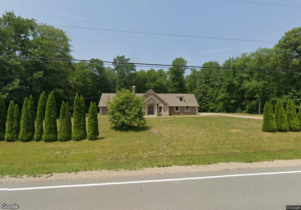
57811 Pear Rd South Bend, IN 46619
Estimated Value: $209,000 - $596,544
3
Beds
3
Baths
1,456
Sq Ft
$298/Sq Ft
Est. Value
About This Home
This home is located at 57811 Pear Rd, South Bend, IN 46619 and is currently estimated at $433,181, approximately $297 per square foot. 57811 Pear Rd is a home located in St. Joseph County with nearby schools including Paton-Churdan Elementary School, Wilson Elementary School, and Clay Intermediate Center.
Ownership History
Date
Name
Owned For
Owner Type
Purchase Details
Closed on
Jan 12, 2024
Sold by
Mayfield Dean E
Bought by
Mayfield Dean E
Current Estimated Value
Home Financials for this Owner
Home Financials are based on the most recent Mortgage that was taken out on this home.
Original Mortgage
$279,000
Outstanding Balance
$274,191
Interest Rate
7.03%
Mortgage Type
New Conventional
Estimated Equity
$158,990
Purchase Details
Closed on
Dec 22, 2023
Sold by
Mayfield Dean E
Bought by
Mayfield Dean E
Home Financials for this Owner
Home Financials are based on the most recent Mortgage that was taken out on this home.
Original Mortgage
$279,000
Outstanding Balance
$274,191
Interest Rate
7.03%
Mortgage Type
New Conventional
Estimated Equity
$158,990
Purchase Details
Closed on
Mar 27, 2017
Sold by
Borsodi Mark A
Bought by
Mayfield Dean E and Ross Kimberly R
Home Financials for this Owner
Home Financials are based on the most recent Mortgage that was taken out on this home.
Original Mortgage
$133,000
Interest Rate
4.15%
Mortgage Type
New Conventional
Purchase Details
Closed on
Jun 7, 2016
Sold by
Borsodi Tracy L
Bought by
Borsodi Mark A
Create a Home Valuation Report for This Property
The Home Valuation Report is an in-depth analysis detailing your home's value as well as a comparison with similar homes in the area
Home Values in the Area
Average Home Value in this Area
Purchase History
| Date | Buyer | Sale Price | Title Company |
|---|---|---|---|
| Mayfield Dean E | -- | Metropolitan Title | |
| Mayfield Dean E | -- | Metropolitan Title | |
| Mayfield Dean E | -- | -- | |
| Borsodi Mark A | -- | -- |
Source: Public Records
Mortgage History
| Date | Status | Borrower | Loan Amount |
|---|---|---|---|
| Open | Mayfield Dean E | $279,000 | |
| Closed | Mayfield Dean E | $279,000 | |
| Previous Owner | Mayfield Dean E | $133,000 |
Source: Public Records
Tax History Compared to Growth
Tax History
| Year | Tax Paid | Tax Assessment Tax Assessment Total Assessment is a certain percentage of the fair market value that is determined by local assessors to be the total taxable value of land and additions on the property. | Land | Improvement |
|---|---|---|---|---|
| 2024 | $4,371 | $579,900 | $64,300 | $515,600 |
| 2023 | $4,430 | $342,600 | $64,300 | $278,300 |
| 2022 | $4,485 | $349,100 | $64,300 | $284,800 |
| 2021 | $3,037 | $241,200 | $30,100 | $211,100 |
| 2020 | $2,378 | $190,800 | $25,200 | $165,600 |
| 2019 | $1,109 | $122,700 | $23,500 | $99,200 |
| 2018 | $1,175 | $124,700 | $22,200 | $102,500 |
| 2017 | $1,262 | $122,000 | $22,200 | $99,800 |
| 2016 | $1,228 | $122,700 | $22,200 | $100,500 |
| 2014 | $1,543 | $163,800 | $75,700 | $88,100 |
Source: Public Records
Map
Nearby Homes
- 26541 Gaited Horse Trail
- 27180 Harrison Rd
- 57223 Pine Needle Ct
- 57210 White Pine Trail
- 57115 White Pine Trail
- 57845 Crumstown Hwy
- 57248 Mcquade St
- 57860 Crumstown Hwy
- 56451 Quince Rd
- 57195 Pinewood Dr
- 55629 Cardinal Dr
- 26366 Hummingbird Rd
- 56435 Eastlea Dr
- 55915 Dorn St
- 56915 Tulip Rd
- 56803 Tulip Rd
- 56729 Tulip Rd
- 56659 Tulip Rd
- 56763 Tulip Rd
- 56611 Tulip Rd
- 57757 Pear Rd
- 57750 Pear Rd
- 57689 Pear Rd Unit 1
- 57723 Pear Rd
- 57929 Pear Rd
- 57920 Pear Rd
- 57655 Pear Rd
- 57712 Pear Rd
- 57954 Pear Rd
- 57947 Pear Rd
- 57656 Pear Rd
- 57606 Pear Rd
- 26811 Harrison Rd
- 26733 Harrison Rd
- 26677 Harrison Rd
- 26627 Harrison Rd
- 26839 Harrison Rd
- 26632 Gaited Horse Trail
- 26632 Gaited Horse Trail Unit 14
- 26575 Harrison Rd