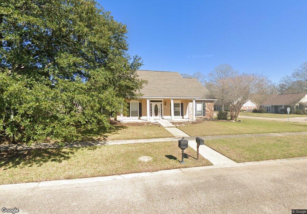
5785 Round Forrest Dr Baton Rouge, LA 70817
Shenandoah NeighborhoodEstimated Value: $308,000 - $330,000
--
Bed
--
Bath
2,313
Sq Ft
$137/Sq Ft
Est. Value
About This Home
This home is located at 5785 Round Forrest Dr, Baton Rouge, LA 70817 and is currently estimated at $315,757, approximately $136 per square foot. 5785 Round Forrest Dr is a home located in East Baton Rouge Parish with nearby schools including Shenandoah Elementary School, Woodlawn Middle School, and Woodlawn High School.
Ownership History
Date
Name
Owned For
Owner Type
Purchase Details
Closed on
Sep 15, 2021
Sold by
West Gilbert and West Jacqueline
Bought by
West Christopher
Current Estimated Value
Home Financials for this Owner
Home Financials are based on the most recent Mortgage that was taken out on this home.
Original Mortgage
$256,500
Outstanding Balance
$233,048
Interest Rate
2.7%
Mortgage Type
New Conventional
Estimated Equity
$82,709
Create a Home Valuation Report for This Property
The Home Valuation Report is an in-depth analysis detailing your home's value as well as a comparison with similar homes in the area
Home Values in the Area
Average Home Value in this Area
Purchase History
| Date | Buyer | Sale Price | Title Company |
|---|---|---|---|
| West Christopher | $285,000 | None Available |
Source: Public Records
Mortgage History
| Date | Status | Borrower | Loan Amount |
|---|---|---|---|
| Open | West Christopher | $256,500 |
Source: Public Records
Tax History Compared to Growth
Tax History
| Year | Tax Paid | Tax Assessment Tax Assessment Total Assessment is a certain percentage of the fair market value that is determined by local assessors to be the total taxable value of land and additions on the property. | Land | Improvement |
|---|---|---|---|---|
| 2024 | $2,351 | $27,080 | $2,300 | $24,780 |
| 2023 | $2,351 | $27,080 | $2,300 | $24,780 |
| 2022 | $2,304 | $27,080 | $2,300 | $24,780 |
| 2021 | $2,651 | $23,130 | $2,300 | $20,830 |
| 2020 | $2,685 | $23,130 | $2,300 | $20,830 |
| 2019 | $2,520 | $20,800 | $2,300 | $18,500 |
| 2018 | $2,489 | $20,800 | $2,300 | $18,500 |
| 2017 | $2,489 | $20,800 | $2,300 | $18,500 |
| 2016 | $1,566 | $20,800 | $2,300 | $18,500 |
| 2015 | $1,565 | $20,800 | $2,300 | $18,500 |
| 2014 | $1,533 | $20,800 | $2,300 | $18,500 |
| 2013 | -- | $20,800 | $2,300 | $18,500 |
Source: Public Records
Map
Nearby Homes
- 17630 Creek Hollow Rd
- 17845 Coffee Rd
- 5821 Fort Sumpter Dr
- 16817 Ticonderoga Ave
- 6041 Cottage Row Dr
- 16825 Chadsford Ave
- 16756 Merrimac Ave
- 17633 E Fort Pickens Ave
- 6813 Garden Hill Dr
- 6130 Wildlife Way Ct
- 6819 Garden Hill Dr
- 6831 Garden Hill Dr
- 5487 Hagerstown Dr
- 16849 Mill Grove Ln
- 5211 Fort Gregg Dr
- 6855 Garden Hill Dr
- 6905 Garden Hill Dr
- 18343 Wildlife Way Dr
- 5730 N Shore Dr
- 6923 Garden Hill Dr
- 5775 Round Forrest Dr
- 5798 Round Forrest Dr
- 5768 Holly Springs Dr
- 5798 Round Forest
- 17412 General Forrest Ave
- 5765 Round Forrest Dr
- 17402 General Forrest Ave
- 5788 Round Forrest Dr
- 5758 Holly Springs Dr
- 17422 General Forrest Ave
- 17360 General Forrest Ave
- 5778 Round Forrest Dr
- 5738 Holly Springs Dr
- 17432 General Forrest Ave
- 5637 Round Forrest Dr
- 5637 Round Forest
- 5646 Round Forest
- 17340 General Forrest Ave
- 5646 Round Forrest Dr
- 5757 Tullahama Dr