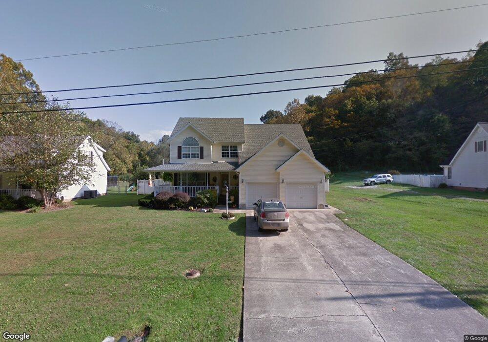
5789 State Route 243 Ironton, OH 45638
Estimated Value: $240,000 - $362,000
3
Beds
3
Baths
2,780
Sq Ft
$102/Sq Ft
Est. Value
About This Home
This home is located at 5789 State Route 243, Ironton, OH 45638 and is currently estimated at $284,871, approximately $102 per square foot. 5789 State Route 243 is a home located in Lawrence County with nearby schools including Dawson-Bryant Elementary School, Dawson-Bryant Middle School, and Dawson-Bryant High School.
Ownership History
Date
Name
Owned For
Owner Type
Purchase Details
Closed on
Jul 7, 1999
Sold by
Brammer Thomas T and Brammer Autu
Bought by
Hicks Steven D and Hicks Nichol
Current Estimated Value
Purchase Details
Closed on
Aug 21, 1996
Sold by
Brammer Thomas J and Brammer Cons
Bought by
Brammer Thomas T and Brammer Autu
Create a Home Valuation Report for This Property
The Home Valuation Report is an in-depth analysis detailing your home's value as well as a comparison with similar homes in the area
Home Values in the Area
Average Home Value in this Area
Purchase History
| Date | Buyer | Sale Price | Title Company |
|---|---|---|---|
| Hicks Steven D | $110,500 | -- | |
| Brammer Thomas T | -- | -- |
Source: Public Records
Tax History Compared to Growth
Tax History
| Year | Tax Paid | Tax Assessment Tax Assessment Total Assessment is a certain percentage of the fair market value that is determined by local assessors to be the total taxable value of land and additions on the property. | Land | Improvement |
|---|---|---|---|---|
| 2024 | -- | $71,870 | $3,050 | $68,820 |
| 2023 | $1,760 | $71,870 | $3,050 | $68,820 |
| 2022 | $1,769 | $71,870 | $3,050 | $68,820 |
| 2021 | $1,619 | $66,210 | $2,880 | $63,330 |
| 2020 | $1,635 | $66,210 | $2,880 | $63,330 |
| 2019 | $1,628 | $66,210 | $2,880 | $63,330 |
| 2018 | $1,508 | $61,320 | $2,880 | $58,440 |
| 2017 | $1,505 | $61,320 | $2,880 | $58,440 |
| 2016 | $1,391 | $61,320 | $2,880 | $58,440 |
| 2015 | $1,356 | $56,050 | $2,890 | $53,160 |
| 2014 | $1,339 | $56,050 | $2,890 | $53,160 |
| 2013 | $1,337 | $56,050 | $2,890 | $53,160 |
Source: Public Records
Map
Nearby Homes
- 6881 State Route 243
- 1122 Township Road 266
- 1122 Township Road 266
- 1225 County Road 15
- 119 County Road 15
- 719 County Road 15
- 2088 State Route 243
- 3859 County Road 15
- 342 Township Road 296
- 156 Township Road 181
- 3421 Central Ave
- 571 County Road 52
- 3032 Carter Ave
- 3024 Carter Ave
- 2829 Carter Ave
- 3230 Bath Ave
- 161 Township Road 1189
- 0 27th Block of Carter Ave
- 103 Carrico Dr
- 2920 Bath Ave
- 5787 State Route 243
- 5807 State Route 243
- 5825 State Route 243
- 60 Private Road 5737 Unit 243
- 5843 State Route 243
- 5723 State Route 243
- 88 Private Road 5737 Unit 243
- 5865 Ohio 243
- 5865 State Route 243
- 45 Pvt Dr 5713 State Route 243
- 87 Pvt Dr 5713 State Route 243
- 5885 State Route 243
- 5699 State Route 243
- 5699 Ohio 243
- 33 Pvt Dr 5713 State Route 243
- 5909 State Route 243
- 5679 State Route 243
- 45 Private Drive 5713
- 5927 Ohio 243
- 5927 State Route 243