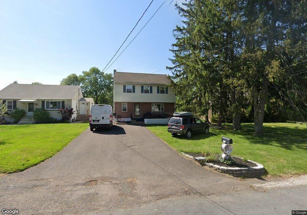
579 Kline Ave Pottstown, PA 19465
North Coventry NeighborhoodEstimated Value: $384,000 - $447,000
2
Beds
2
Baths
2,150
Sq Ft
$191/Sq Ft
Est. Value
About This Home
This home is located at 579 Kline Ave, Pottstown, PA 19465 and is currently estimated at $411,531, approximately $191 per square foot. 579 Kline Ave is a home located in Chester County with nearby schools including North Coventry Elementary School, Owen J Roberts Middle School, and Owen J Roberts High School.
Ownership History
Date
Name
Owned For
Owner Type
Purchase Details
Closed on
Jan 18, 2002
Sold by
Dantonio Dean M and Dantonio Margaret M
Bought by
Porter Gary L and Porter Gail L
Current Estimated Value
Home Financials for this Owner
Home Financials are based on the most recent Mortgage that was taken out on this home.
Original Mortgage
$124,019
Outstanding Balance
$50,824
Interest Rate
7.08%
Mortgage Type
FHA
Estimated Equity
$360,707
Create a Home Valuation Report for This Property
The Home Valuation Report is an in-depth analysis detailing your home's value as well as a comparison with similar homes in the area
Home Values in the Area
Average Home Value in this Area
Purchase History
| Date | Buyer | Sale Price | Title Company |
|---|---|---|---|
| Porter Gary L | $125,000 | -- |
Source: Public Records
Mortgage History
| Date | Status | Borrower | Loan Amount |
|---|---|---|---|
| Open | Porter Gary L | $124,019 |
Source: Public Records
Tax History Compared to Growth
Tax History
| Year | Tax Paid | Tax Assessment Tax Assessment Total Assessment is a certain percentage of the fair market value that is determined by local assessors to be the total taxable value of land and additions on the property. | Land | Improvement |
|---|---|---|---|---|
| 2025 | $4,771 | $112,640 | $24,730 | $87,910 |
| 2024 | $4,771 | $112,640 | $24,730 | $87,910 |
| 2023 | $4,704 | $112,640 | $24,730 | $87,910 |
| 2022 | $4,607 | $112,640 | $24,730 | $87,910 |
| 2021 | $4,527 | $112,640 | $24,730 | $87,910 |
| 2020 | $4,413 | $112,640 | $24,730 | $87,910 |
| 2019 | $4,332 | $112,640 | $24,730 | $87,910 |
| 2018 | $4,215 | $112,640 | $24,730 | $87,910 |
| 2017 | $4,106 | $112,640 | $24,730 | $87,910 |
| 2016 | $3,310 | $112,640 | $24,730 | $87,910 |
| 2015 | $3,310 | $112,640 | $24,730 | $87,910 |
| 2014 | $3,310 | $112,640 | $24,730 | $87,910 |
Source: Public Records
Map
Nearby Homes
- 435 Kline Ave
- 468 Kline Ave
- 84 W Schuylkill Rd
- 738 Union Ave
- 383 W Cedarville Rd
- 277 Industrial Hwy
- 797 Union Ave
- 1132 Wendler Cir
- 325 South St
- 410 Cherry St
- 425 Laurel St
- 426 Cherry St
- 110 S Franklin St
- 363 New St
- 428 South St
- 48 Chestnut St
- 0000 Chestnut St
- 780 E Cedarville Rd
- 322 Chestnut St
- 151 N York St