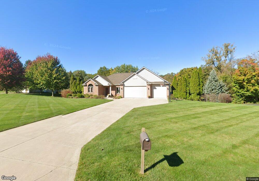
579 Northridge Dr Holland, MI 49423
Estimated Value: $682,000 - $804,000
5
Beds
4
Baths
4,061
Sq Ft
$179/Sq Ft
Est. Value
About This Home
This home is located at 579 Northridge Dr, Holland, MI 49423 and is currently estimated at $725,635, approximately $178 per square foot. 579 Northridge Dr is a home located in Ottawa County with nearby schools including Woodbridge Elementary School, Cityside Middle School, and Zeeland East High School.
Ownership History
Date
Name
Owned For
Owner Type
Purchase Details
Closed on
Jun 12, 2023
Sold by
Kloosterman Kevin and Kloosterman Nicole
Bought by
Kloosterman Family Trust
Current Estimated Value
Purchase Details
Closed on
Sep 9, 2022
Sold by
Boetsma Terry L and Boetsma Cheryl L
Bought by
Kloosterman Kevin and Kloosterman Nicole
Purchase Details
Closed on
Jun 29, 2010
Sold by
Boetsma Terry L and Boetsma Cheryl
Bought by
Terry & Cheryl Boetsma Trust
Create a Home Valuation Report for This Property
The Home Valuation Report is an in-depth analysis detailing your home's value as well as a comparison with similar homes in the area
Home Values in the Area
Average Home Value in this Area
Purchase History
| Date | Buyer | Sale Price | Title Company |
|---|---|---|---|
| Kloosterman Family Trust | -- | None Listed On Document | |
| Kloosterman Kevin | -- | -- | |
| Boetsma Terry L | -- | -- | |
| Terry & Cheryl Boetsma Trust | -- | None Available |
Source: Public Records
Tax History Compared to Growth
Tax History
| Year | Tax Paid | Tax Assessment Tax Assessment Total Assessment is a certain percentage of the fair market value that is determined by local assessors to be the total taxable value of land and additions on the property. | Land | Improvement |
|---|---|---|---|---|
| 2025 | $7,133 | $324,600 | $0 | $0 |
| 2024 | $4,499 | $321,500 | $0 | $0 |
| 2023 | $6,680 | $319,400 | $0 | $0 |
| 2022 | $6,463 | $278,500 | $0 | $0 |
| 2021 | $6,275 | $232,300 | $0 | $0 |
| 2020 | $6,210 | $219,400 | $0 | $0 |
| 2019 | $6,111 | $160,000 | $0 | $0 |
| 2018 | $5,629 | $205,000 | $45,000 | $160,000 |
| 2017 | $5,548 | $207,800 | $0 | $0 |
| 2016 | $5,508 | $197,800 | $0 | $0 |
| 2015 | $5,184 | $179,200 | $0 | $0 |
| 2014 | $5,184 | $171,400 | $0 | $0 |
Source: Public Records
Map
Nearby Homes
- 1391 Quarterline Commons
- Lot 17 of Peppermint Dr
- Lot 16 Peppermint Dr
- Lot 15 Peppermint Dr
- 179 Peppermint Dr
- 165 Peppermint Dr
- 171 Peppermint Dr
- VL Ottogan St
- 403 Stratford Way
- 160 Sorrento Dr
- 1214 Euna Vista Dr
- 5232 E Sunfield Ln
- 955 Kenwood Dr
- 5216 Mulberry Ln
- 5219 Hollow Ln
- 5221 Hollow Ln
- 10058 Prairie Grass Ct
- 866 E 24th St Unit Parcel A
- 1078 Lynden Rd
- 1101 Lynden Rd
- 547 Northridge Dr
- 550 Northridge Dr
- 584 Northridge Dr
- 527 Northridge Dr Unit 13
- 616 Northridge Dr
- 616 Northridge Dr Unit 20
- 510 Northridge Dr
- 633 Northridge Dr
- 0 Northridge Dr
- 507 Northridge Dr
- 10811 Westridge Way
- 10835 Westridge Way Unit 10
- 10835 Westridge Way
- 490 Northridge Dr
- 647 Northridge Dr
- 10897 Mason St
- 638 Northridge Dr
- 650 Northridge Dr
- 10623 MacAtawa Ln
- 10641 MacAtawa Ln