Estimated Value: $320,195 - $360,000
3
Beds
2
Baths
1,389
Sq Ft
$244/Sq Ft
Est. Value
About This Home
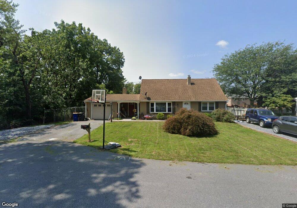
This home is located at 58 Amanda Ave, Leola, PA 17540 and is currently estimated at $338,799, approximately $243 per square foot. 58 Amanda Ave is a home located in Lancaster County with nearby schools including Leola Elementary School, Gerald G. Huesken Middle School, and Conestoga Valley High School.
Ownership History
Date
Name
Owned For
Owner Type
Purchase Details
Closed on
Jun 4, 2025
Sold by
Diem Ronald L and King Ashley L
Bought by
Diem Ronald L
Current Estimated Value
Purchase Details
Closed on
May 8, 2017
Sold by
Garman Dean L and Garman Karen L
Bought by
Diem Ronald and King Ashley
Home Financials for this Owner
Home Financials are based on the most recent Mortgage that was taken out on this home.
Original Mortgage
$189,994
Interest Rate
4.14%
Mortgage Type
FHA
Purchase Details
Closed on
Jan 13, 2017
Sold by
Manning Robert J and Manning Michelle D
Bought by
Garman Dean L and Garman Karen L
Purchase Details
Closed on
Jun 29, 2005
Sold by
Witherow Edward and Witherow Tracy
Bought by
Manning Robert J and Manning Michelle D
Home Financials for this Owner
Home Financials are based on the most recent Mortgage that was taken out on this home.
Original Mortgage
$119,250
Interest Rate
5.59%
Mortgage Type
Fannie Mae Freddie Mac
Create a Home Valuation Report for This Property
The Home Valuation Report is an in-depth analysis detailing your home's value as well as a comparison with similar homes in the area
Home Values in the Area
Average Home Value in this Area
Purchase History
| Date | Buyer | Sale Price | Title Company |
|---|---|---|---|
| Diem Ronald L | $284,262 | None Listed On Document | |
| Diem Ronald | $193,500 | None Available | |
| Garman Dean L | $100,000 | None Available | |
| Manning Robert J | $159,000 | -- |
Source: Public Records
Mortgage History
| Date | Status | Borrower | Loan Amount |
|---|---|---|---|
| Previous Owner | Diem Ronald | $189,994 | |
| Previous Owner | Manning Robert J | $119,250 |
Source: Public Records
Tax History Compared to Growth
Tax History
| Year | Tax Paid | Tax Assessment Tax Assessment Total Assessment is a certain percentage of the fair market value that is determined by local assessors to be the total taxable value of land and additions on the property. | Land | Improvement |
|---|---|---|---|---|
| 2025 | $3,209 | $160,600 | $46,500 | $114,100 |
| 2024 | $3,209 | $160,600 | $46,500 | $114,100 |
| 2023 | $3,143 | $160,600 | $46,500 | $114,100 |
| 2022 | $3,064 | $160,600 | $46,500 | $114,100 |
| 2021 | $2,955 | $160,600 | $46,500 | $114,100 |
| 2020 | $2,955 | $160,600 | $46,500 | $114,100 |
| 2019 | $2,891 | $160,600 | $46,500 | $114,100 |
| 2018 | $3,361 | $160,600 | $46,500 | $114,100 |
| 2016 | $2,905 | $136,000 | $30,600 | $105,400 |
| 2015 | $739 | $136,000 | $30,600 | $105,400 |
| 2014 | $2,017 | $136,000 | $30,600 | $105,400 |
Source: Public Records
Map
Nearby Homes
- 248 E Main St
- 39 N Maple Ave
- 68 Horseshoe Rd
- 466 E Main St
- 456 Brendon Dr
- 71 Apricot Ave
- 259 Raspberry Rd
- 70 Hellers Church Rd
- 753 Walnut St
- 130 Snapdragon Dr
- 425 Mill Creek Rd
- 322 Wissler Rd
- 339 Enterprise Dr
- 323 Enterprise Dr
- 205 E Main St
- 103 Fairhill Dr
- 2596 Old Philadelphia Pike
- 80 Diller Ave Unit 9
- 50 Allen Rd
- 41 Ashlea Village