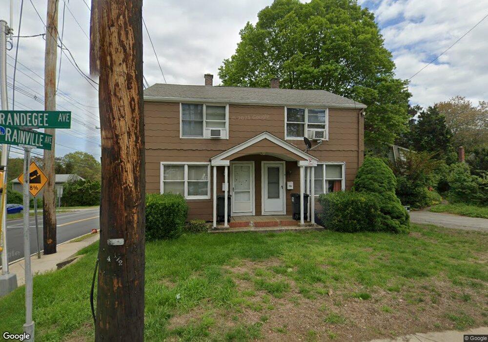
58 Brandegee Ave Groton, CT 06340
Estimated Value: $342,000 - $413,000
4
Beds
2
Baths
1,664
Sq Ft
$226/Sq Ft
Est. Value
About This Home
This home is located at 58 Brandegee Ave, Groton, CT 06340 and is currently estimated at $376,171, approximately $226 per square foot. 58 Brandegee Ave is a home located in New London County with nearby schools including Catherine Kolnaski STEAM Magnet School, Groton Middle School, and Robert E. Fitch High School.
Ownership History
Date
Name
Owned For
Owner Type
Purchase Details
Closed on
Feb 10, 2016
Sold by
Ken Inc
Bought by
Nth 2 Llc
Current Estimated Value
Purchase Details
Closed on
Feb 17, 2000
Sold by
Noe John E
Bought by
Kes Inc
Home Financials for this Owner
Home Financials are based on the most recent Mortgage that was taken out on this home.
Original Mortgage
$75,200
Interest Rate
9.03%
Create a Home Valuation Report for This Property
The Home Valuation Report is an in-depth analysis detailing your home's value as well as a comparison with similar homes in the area
Home Values in the Area
Average Home Value in this Area
Purchase History
| Date | Buyer | Sale Price | Title Company |
|---|---|---|---|
| Nth 2 Llc | -- | -- | |
| Kes Inc | $94,000 | -- |
Source: Public Records
Mortgage History
| Date | Status | Borrower | Loan Amount |
|---|---|---|---|
| Previous Owner | Kes Inc | $75,200 |
Source: Public Records
Tax History
| Year | Tax Paid | Tax Assessment Tax Assessment Total Assessment is a certain percentage of the fair market value that is determined by local assessors to be the total taxable value of land and additions on the property. | Land | Improvement |
|---|---|---|---|---|
| 2025 | $4,521 | $156,380 | $80,577 | $75,803 |
| 2024 | $4,205 | $156,380 | $80,577 | $75,803 |
| 2023 | $4,035 | $156,380 | $48,090 | $108,290 |
| 2022 | $3,902 | $156,380 | $48,090 | $108,290 |
| 2021 | $3,423 | $113,050 | $31,220 | $81,830 |
| 2020 | $3,325 | $113,050 | $31,220 | $81,830 |
| 2019 | $3,219 | $113,050 | $31,220 | $81,830 |
| 2018 | $3,250 | $113,050 | $31,220 | $81,830 |
| 2017 | $3,261 | $113,050 | $31,220 | $81,830 |
| 2016 | $3,225 | $118,720 | $38,990 | $79,730 |
| 2015 | $3,184 | $118,720 | $38,990 | $79,730 |
| 2014 | $2,962 | $118,720 | $38,990 | $79,730 |
Source: Public Records
Map
Nearby Homes
- 55 Virginia Ave Unit C
- 231 Poquonnock Rd
- 3 George Ave
- 136 Blueberry Hill Rd
- 119 High Rock Rd
- 10 B St
- 85 Baker Ave
- 374 Meridian Street Extension Unit 68
- 576 Shennecossett Rd Unit G69
- 172 D St
- 174 D St
- 110 Valley Rd
- 1043 Poquonnock Rd
- 279 Bridge St Unit 10
- 25 Morgan Ct
- 50 School St
- 26 Bakers Cove Ln
- 132 Thames St Unit R
- 108 Thames St
- 0 Bonnie Cir
- 64 Brandegee Ave
- 70 Brandegee Ave
- 72 Rainville Ave
- 74 Brandegee Ave
- 78 Brandegee Ave
- 65 Brandegee Ave
- 84 Rainville Ave
- 75 Brandegee Ave
- 80 Brandegee Ave
- 96 Rainville Ave
- 81 Brandegee Ave
- 88 Brandegee Ave
- 96 Virginia Ave
- 115 Elderkin Ave
- 94 Brandegee Ave
- 91 Brandegee Ave
- 311 Poquonnock Rd
- 105 Elderkin Ave
- 92 Virginia Ave
- 98 Brandegee Ave
Your Personal Tour Guide
Ask me questions while you tour the home.