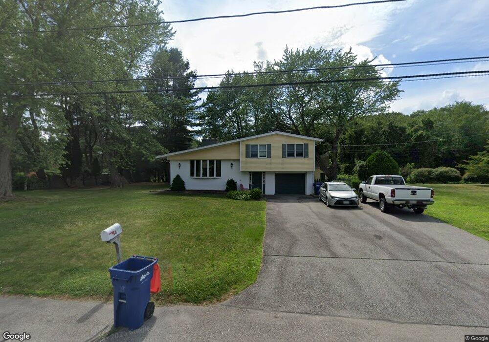
58 Talbot Way Seekonk, MA 02771
Estimated Value: $493,000 - $627,916
4
Beds
2
Baths
1,901
Sq Ft
$292/Sq Ft
Est. Value
About This Home
This home is located at 58 Talbot Way, Seekonk, MA 02771 and is currently estimated at $555,229, approximately $292 per square foot. 58 Talbot Way is a home located in Bristol County with nearby schools including Seekonk High School, St Margaret School, and The Wolf School.
Ownership History
Date
Name
Owned For
Owner Type
Purchase Details
Closed on
Oct 6, 1995
Sold by
Nelson Eleanor M
Bought by
Simas Jaime J and Nelson Wendy
Current Estimated Value
Home Financials for this Owner
Home Financials are based on the most recent Mortgage that was taken out on this home.
Original Mortgage
$109,000
Outstanding Balance
$784
Interest Rate
7.86%
Mortgage Type
Purchase Money Mortgage
Estimated Equity
$554,445
Create a Home Valuation Report for This Property
The Home Valuation Report is an in-depth analysis detailing your home's value as well as a comparison with similar homes in the area
Home Values in the Area
Average Home Value in this Area
Purchase History
| Date | Buyer | Sale Price | Title Company |
|---|---|---|---|
| Simas Jaime J | $140,000 | -- | |
| Simas Jaime J | $140,000 | -- |
Source: Public Records
Mortgage History
| Date | Status | Borrower | Loan Amount |
|---|---|---|---|
| Open | Simas Jaime J | $32,000 | |
| Open | Simas Jaime J | $109,000 | |
| Closed | Simas Jaime J | $109,000 |
Source: Public Records
Tax History Compared to Growth
Tax History
| Year | Tax Paid | Tax Assessment Tax Assessment Total Assessment is a certain percentage of the fair market value that is determined by local assessors to be the total taxable value of land and additions on the property. | Land | Improvement |
|---|---|---|---|---|
| 2025 | $6,292 | $509,500 | $196,400 | $313,100 |
| 2024 | $5,955 | $482,200 | $196,400 | $285,800 |
| 2023 | $5,644 | $430,500 | $176,800 | $253,700 |
| 2022 | $5,183 | $388,500 | $169,800 | $218,700 |
| 2021 | $4,963 | $365,700 | $151,500 | $214,200 |
| 2020 | $4,748 | $360,500 | $151,200 | $209,300 |
| 2019 | $4,613 | $353,200 | $151,200 | $202,000 |
| 2018 | $4,352 | $326,000 | $151,200 | $174,800 |
| 2017 | $4,202 | $312,200 | $144,700 | $167,500 |
| 2016 | $4,201 | $313,300 | $144,700 | $168,600 |
| 2015 | $4,029 | $304,500 | $144,700 | $159,800 |
Source: Public Records
Map
Nearby Homes
- 50 Dexter Ave
- 87 Baker St
- 282 West Ave
- 9 Gerry Dr
- 243 West Ave
- 245 Manton St
- 245 Manton St Unit 83
- 91 Seabiscuit Place
- 188 Newman Ave
- 242 Manton #41 St
- 242 St
- 63 Whirlaway Place
- 15 Lindsey Ct
- 1150 Newman Ave
- 15 East Dr
- 25 East Dr
- 181 Sherman Ave
- 724 Beverage Hill Ave Unit 302
- 728 Beverage Hill Ave Unit 24
- 63 East Dr
- 46 Talbot Way
- 70 Talbot Way
- 2212 Talbot Way Unit 12212
- 2411 Talbot Way Unit 12411
- 2207 Talbot Way Unit 12207
- 2412 Talbot Way Unit 12412
- 2306 Talbot Way Unit 12306
- 2212 Talbot Way Unit 212
- 2308 Talbot Way Unit 308
- 2407 Talbot Way Unit 407
- 2309 Talbot Way Unit 309
- 59 Talbot Way
- 71 Talbot Way
- 34 Talbot Way
- 43 Talbot Way
- 82 Talbot Way
- 27 Tompson Dr
- 83 Talbot Way Unit 1
- 83 Talbot Way
- 37 Tompson Dr