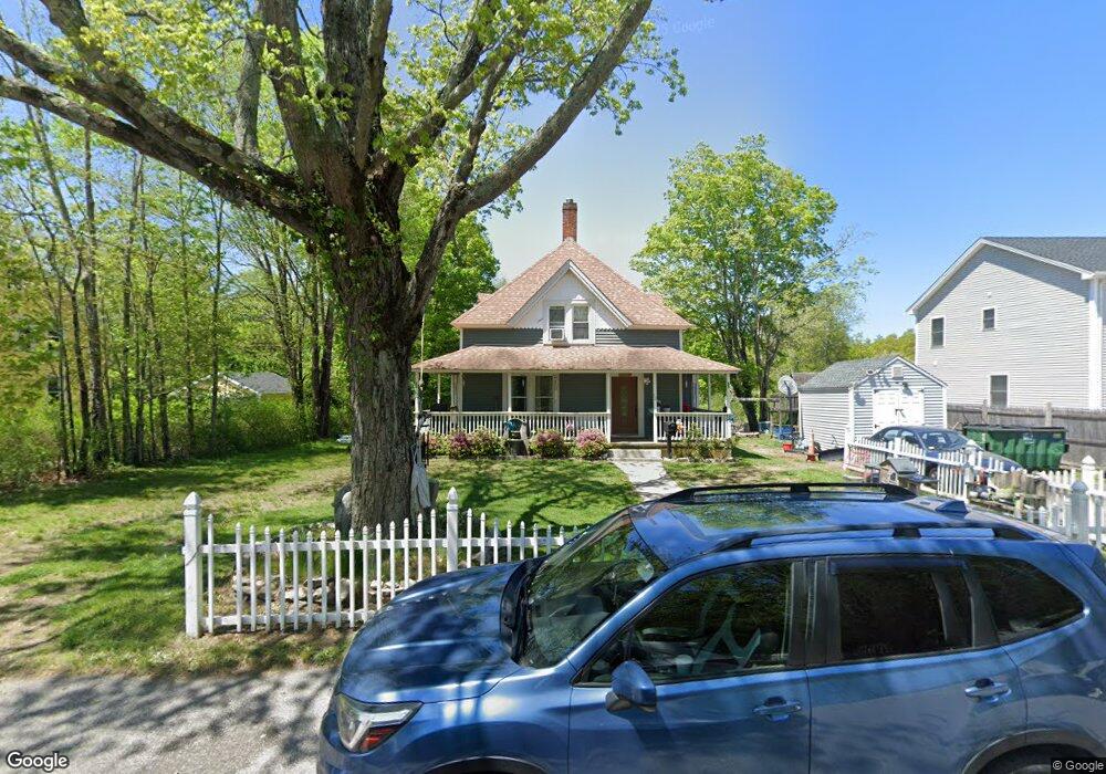
58 White Rock Rd Westerly, RI 02891
Estimated Value: $414,000 - $467,000
4
Beds
1
Bath
1,739
Sq Ft
$253/Sq Ft
Est. Value
About This Home
This home is located at 58 White Rock Rd, Westerly, RI 02891 and is currently estimated at $440,534, approximately $253 per square foot. 58 White Rock Rd is a home located in Washington County with nearby schools including Westerly High School, North Stonington Christian Academy, and St. Michael School.
Ownership History
Date
Name
Owned For
Owner Type
Purchase Details
Closed on
Nov 10, 1994
Sold by
Hellwig Oskar and Hellwig Eva
Bought by
Johnson Drew W and Johnson Laurialye
Current Estimated Value
Home Financials for this Owner
Home Financials are based on the most recent Mortgage that was taken out on this home.
Original Mortgage
$76,000
Interest Rate
8.78%
Purchase Details
Closed on
Jul 1, 1994
Sold by
Storey Clarice May
Bought by
Hellwig Oskar and Hellwig Eva
Create a Home Valuation Report for This Property
The Home Valuation Report is an in-depth analysis detailing your home's value as well as a comparison with similar homes in the area
Home Values in the Area
Average Home Value in this Area
Purchase History
| Date | Buyer | Sale Price | Title Company |
|---|---|---|---|
| Johnson Drew W | $96,000 | -- | |
| Hellwig Oskar | $40,000 | -- |
Source: Public Records
Mortgage History
| Date | Status | Borrower | Loan Amount |
|---|---|---|---|
| Open | Hellwig Oskar | $206,000 | |
| Closed | Hellwig Oskar | $216,000 | |
| Closed | Hellwig Oskar | $76,000 |
Source: Public Records
Tax History Compared to Growth
Tax History
| Year | Tax Paid | Tax Assessment Tax Assessment Total Assessment is a certain percentage of the fair market value that is determined by local assessors to be the total taxable value of land and additions on the property. | Land | Improvement |
|---|---|---|---|---|
| 2025 | $2,620 | $336,700 | $140,100 | $196,600 |
| 2024 | $2,632 | $251,900 | $100,100 | $151,800 |
| 2023 | $2,559 | $251,900 | $100,100 | $151,800 |
| 2022 | $2,544 | $251,900 | $100,100 | $151,800 |
| 2021 | $2,556 | $211,900 | $87,000 | $124,900 |
| 2020 | $2,511 | $211,900 | $87,000 | $124,900 |
| 2019 | $2,488 | $211,900 | $87,000 | $124,900 |
| 2018 | $2,277 | $184,400 | $76,800 | $107,600 |
| 2017 | $2,213 | $184,400 | $76,800 | $107,600 |
| 2016 | $2,213 | $184,400 | $76,800 | $107,600 |
| 2015 | $2,240 | $199,500 | $88,900 | $110,600 |
| 2014 | $2,204 | $199,500 | $88,900 | $110,600 |
Source: Public Records
Map
Nearby Homes
- 102 White Rock Rd Unit B
- 15 Faulise Ave
- 4 N Joseph St
- 414 Liberty St
- 3 Joseph Ln
- 8 Alice Ct
- 12 Henry St
- 12 Ava St
- 87 Elmridge Rd
- 19 Pond St
- 7 Richmond St
- 42 Meadowview Terrace Unit 44
- 277 High St
- 186 High St
- 223 High St Unit S
- 19 Pleasant St
- 21 Nichols Ln
- 19 Nichols Ln
- 17 West St Unit A-2
- 140 High St Unit 307
- 60 White Rock Rd
- 56 White Rock Rd
- 55 White Rock Rd
- 59 White Rock Rd
- 61 White Rock Rd
- 63 White Rock Rd
- 65 White Rock Rd
- 67 White Rock Rd
- 71 White Rock Rd
- 3B Cottage St
- 3 Cottage St Unit B
- 3 Cottage St
- 75 White Rock Rd
- 77 White Rock Rd
- 2 Wall St
- 4 Wall St
- 2 Knight St
- 79 White Rock Rd
- 79 White Rock Rd
- 4 Knight St