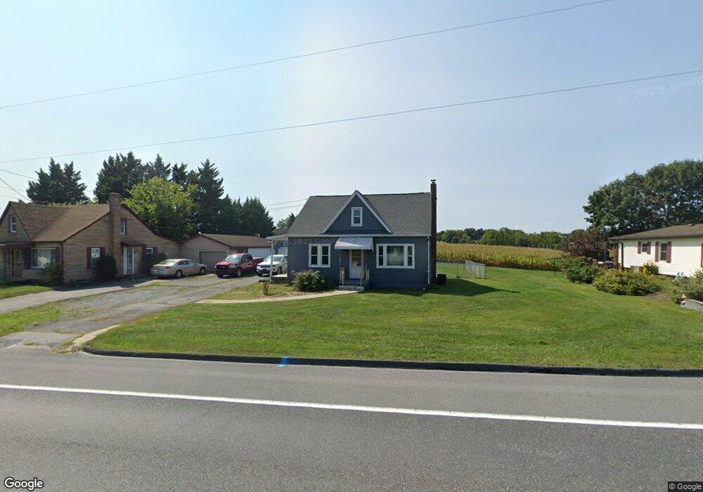
5800 Buchanan Trail E Waynesboro, PA 17268
Estimated Value: $102,569 - $208,000
--
Bed
--
Bath
1,037
Sq Ft
$171/Sq Ft
Est. Value
About This Home
This home is located at 5800 Buchanan Trail E, Waynesboro, PA 17268 and is currently estimated at $176,892, approximately $170 per square foot. 5800 Buchanan Trail E is a home located in Franklin County with nearby schools including Waynesboro Area Senior High School, St. Andrew Catholic School, and Noah's Ark Christian Child Care Center.
Ownership History
Date
Name
Owned For
Owner Type
Purchase Details
Closed on
Jun 15, 2020
Sold by
Stone Tina and Wingert Tina M
Bought by
Stone Jeffrey L
Current Estimated Value
Home Financials for this Owner
Home Financials are based on the most recent Mortgage that was taken out on this home.
Original Mortgage
$131,502
Interest Rate
2.8%
Mortgage Type
FHA
Create a Home Valuation Report for This Property
The Home Valuation Report is an in-depth analysis detailing your home's value as well as a comparison with similar homes in the area
Home Values in the Area
Average Home Value in this Area
Purchase History
| Date | Buyer | Sale Price | Title Company |
|---|---|---|---|
| Stone Jeffrey L | -- | Mortgage Information Svcs In |
Source: Public Records
Mortgage History
| Date | Status | Borrower | Loan Amount |
|---|---|---|---|
| Closed | Stone Jeffrey L | $131,502 |
Source: Public Records
Tax History Compared to Growth
Tax History
| Year | Tax Paid | Tax Assessment Tax Assessment Total Assessment is a certain percentage of the fair market value that is determined by local assessors to be the total taxable value of land and additions on the property. | Land | Improvement |
|---|---|---|---|---|
| 2025 | $2,143 | $13,950 | $800 | $13,150 |
| 2024 | $2,080 | $13,950 | $800 | $13,150 |
| 2023 | $2,019 | $13,950 | $800 | $13,150 |
| 2022 | $1,959 | $13,950 | $800 | $13,150 |
| 2021 | $1,903 | $13,950 | $800 | $13,150 |
| 2020 | $1,858 | $13,830 | $800 | $13,030 |
| 2019 | $1,816 | $13,830 | $800 | $13,030 |
| 2018 | $1,757 | $13,830 | $800 | $13,030 |
| 2017 | $1,719 | $13,830 | $800 | $13,030 |
| 2016 | $396 | $13,830 | $800 | $13,030 |
| 2015 | $369 | $13,830 | $800 | $13,030 |
| 2014 | $369 | $13,830 | $800 | $13,030 |
Source: Public Records
Map
Nearby Homes
- 12041 Koons Rd
- TBD Whippet Trail
- TBD Harrier Way
- 5385 Harrier Way
- 5377 Harrier Way
- 4798 Gray Hawk Dr Unit 17
- 12152 Red Hawk Dr
- 6668 Marsh Rd
- 6287 Marsh Rd
- 422 Cleveland Ave
- 462 Scott Ave Unit 4
- 217 Fairview Ave
- 105 Fairview Ave
- 0 Westview Ave
- 130 Hamilton Ave
- 208 Hamilton Ave
- 286 W 2nd St
- 336 Fairmount Ave
- 129 Coquina Sands Dr Unit 51
- 5790 Buchanan Trail E
- 5826 Buchanan Trail E
- 5850 Buchanan Trail E
- 5782 Buchanan Trail E
- 5724 Tick Ridge Rd
- 5825 Buchanan Trail E
- 5712 Tick Ridge Rd
- 5740 Tick Ridge Rd
- 5858 Buchanan Trail E
- 5884 Buchanan Trail E
- 5788 Tick Ridge Rd
- 5684 Tick Ridge Rd
- 5796 Tick Ridge Rd
- 0 Tick Ridge Road Lot #30 Unit 1003622082
- 0 Tick Ridge Road Lot #29 Unit 1003622304
- 5818 Tick Ridge Rd
- 5727 Tick Ridge Rd
- 5677 Tick Ridge Rd
- 5717 Tick Ridge Rd
- 5657 Tick Ridge Rd