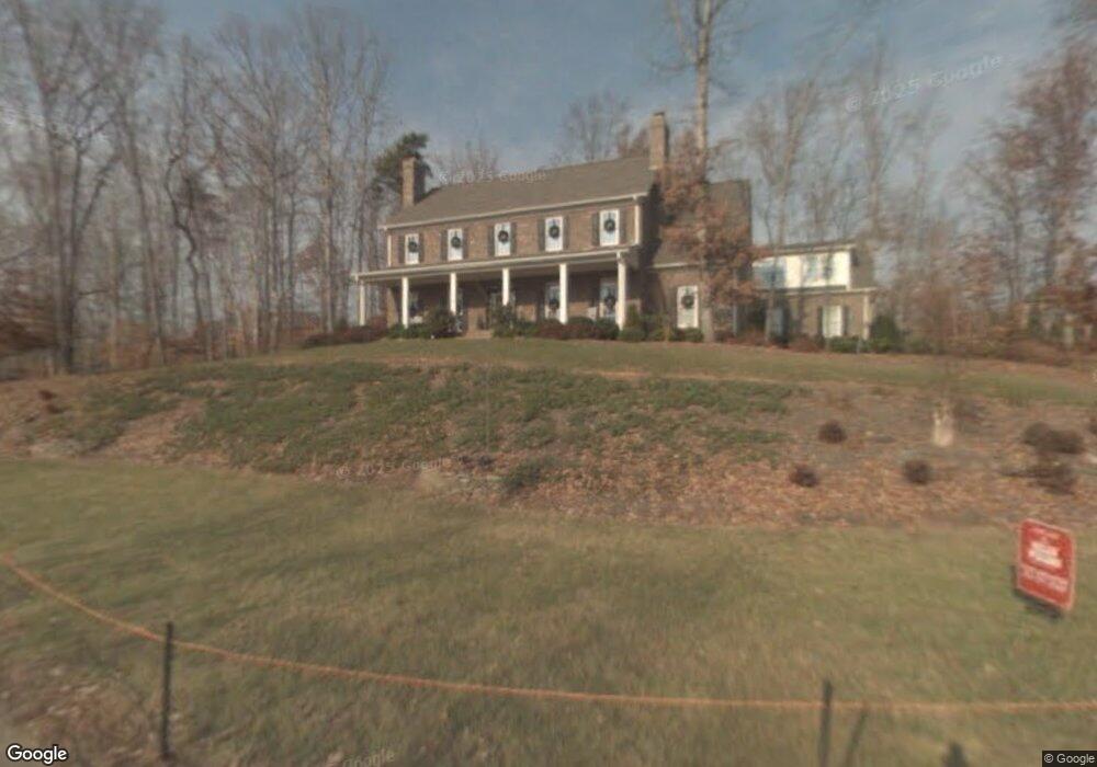
5800 Mashoes Ct Summerfield, NC 27358
Estimated Value: $750,888 - $937,000
4
Beds
5
Baths
4,354
Sq Ft
$199/Sq Ft
Est. Value
About This Home
This home is located at 5800 Mashoes Ct, Summerfield, NC 27358 and is currently estimated at $867,972, approximately $199 per square foot. 5800 Mashoes Ct is a home located in Guilford County with nearby schools including Summerfield Elementary School, Northern Guilford Middle School, and Northern Guilford High School.
Ownership History
Date
Name
Owned For
Owner Type
Purchase Details
Closed on
Jan 18, 2023
Sold by
Foxworth James M and Foxworth Elizabeth Diane
Bought by
Foxworth Family Trust
Current Estimated Value
Purchase Details
Closed on
Sep 20, 2002
Sold by
Henson Farms Llc
Bought by
Foxworth James M and Foxworth Elizabeth Diane
Home Financials for this Owner
Home Financials are based on the most recent Mortgage that was taken out on this home.
Original Mortgage
$300,000
Interest Rate
4.75%
Mortgage Type
Construction
Create a Home Valuation Report for This Property
The Home Valuation Report is an in-depth analysis detailing your home's value as well as a comparison with similar homes in the area
Home Values in the Area
Average Home Value in this Area
Purchase History
| Date | Buyer | Sale Price | Title Company |
|---|---|---|---|
| Foxworth Family Trust | -- | -- | |
| Foxworth James M | $97,000 | -- |
Source: Public Records
Mortgage History
| Date | Status | Borrower | Loan Amount |
|---|---|---|---|
| Previous Owner | Foxworth James M | $300,000 |
Source: Public Records
Tax History Compared to Growth
Tax History
| Year | Tax Paid | Tax Assessment Tax Assessment Total Assessment is a certain percentage of the fair market value that is determined by local assessors to be the total taxable value of land and additions on the property. | Land | Improvement |
|---|---|---|---|---|
| 2025 | $5,576 | $627,200 | $95,000 | $532,200 |
| 2024 | $5,576 | $627,200 | $95,000 | $532,200 |
| 2023 | $5,576 | $627,200 | $95,000 | $532,200 |
| 2022 | $5,576 | $627,200 | $95,000 | $532,200 |
| 2021 | $4,840 | $544,400 | $85,000 | $459,400 |
| 2020 | $4,840 | $544,400 | $85,000 | $459,400 |
| 2019 | $4,840 | $544,400 | $0 | $0 |
| 2018 | $4,816 | $544,400 | $0 | $0 |
| 2017 | $4,840 | $544,400 | $0 | $0 |
| 2016 | $4,911 | $537,600 | $0 | $0 |
| 2015 | $4,938 | $537,600 | $0 | $0 |
| 2014 | $4,992 | $537,600 | $0 | $0 |
Source: Public Records
Map
Nearby Homes
- 5603 Monk Ct
- 7107 Lake Henson Dr
- 7020 Marseilles Ct
- 2327 Scalesville Rd
- 7376 Henson Forest Dr
- 6307 Alley Ridge Way
- 7399 Henson Forest Dr
- 6981 Brandi Wood Cir
- 4701 US Highway 220 N
- 5680 Green Dale Ct
- 7004 Westfield Village Cir
- 6998 Colleen Ct
- 7003 Pearson Run Ct
- 7503 William Bailey Rd
- 7825 Spencer Brook Dr
- 7819 Wilson Farm Rd
- 7107 Lanier Rd
- 7497 Shadow Creek Dr
- 7645 Braelands Dr
- 5405 Briardenn Ct
- 5801 Snow Hill Dr
- 5803 Snow Hill Dr
- 5800 Harriet Ct
- 5805 Snow Hill Dr
- 5802 Mashoes Ct
- 7102 Sarah Lamar Dr
- 5707 Snow Hill Dr
- 5805 Mashoes Ct
- 7100 Sarah Lamar Dr
- 5803 Mashoes Ct
- 5807 Snow Hill Dr
- 5802 Harriet Ct
- 5802 Snow Hill Dr
- 5705 Snow Hill Dr
- 5800 Snow Hill Dr
- 5706 Snow Hill Dr
- 5804 Snow Hill Dr
- 5804 Harriet Ct
- 5801 Harriet Ct
- 5704 Snow Hill Dr