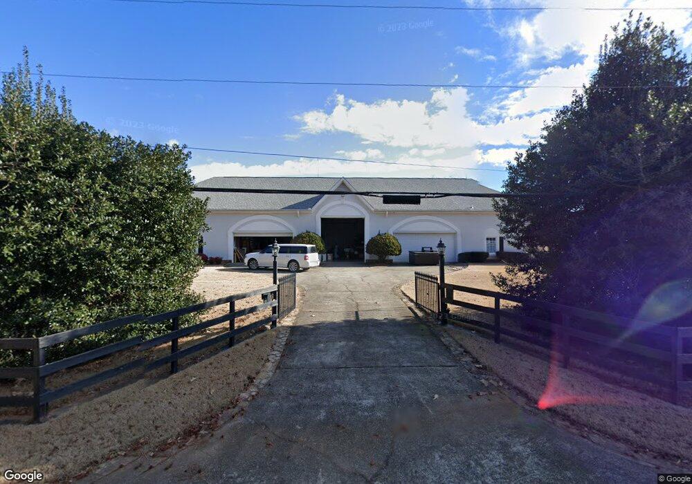
5805 Shadburn Ferry Rd Buford, GA 30518
Estimated Value: $1,254,000 - $2,095,881
3
Beds
7
Baths
10,033
Sq Ft
$167/Sq Ft
Est. Value
About This Home
This home is located at 5805 Shadburn Ferry Rd, Buford, GA 30518 and is currently estimated at $1,674,941, approximately $166 per square foot. 5805 Shadburn Ferry Rd is a home located in Gwinnett County with nearby schools including White Oak Elementary School, Lanier Middle School, and Lanier High School.
Ownership History
Date
Name
Owned For
Owner Type
Purchase Details
Closed on
Jan 22, 2016
Sold by
Dorsett Properties Llc
Bought by
Snider Nicholas D
Current Estimated Value
Purchase Details
Closed on
Dec 20, 2012
Sold by
Dorsett Barbara
Bought by
Dorsett Properties Llc
Purchase Details
Closed on
Jan 28, 2002
Sold by
Dorsett Claude G
Bought by
Dorsett Barbara
Purchase Details
Closed on
Jul 15, 1999
Sold by
Clarke Helen B
Bought by
Bagby Myrlte L
Create a Home Valuation Report for This Property
The Home Valuation Report is an in-depth analysis detailing your home's value as well as a comparison with similar homes in the area
Home Values in the Area
Average Home Value in this Area
Purchase History
| Date | Buyer | Sale Price | Title Company |
|---|---|---|---|
| Snider Nicholas D | $1,075,000 | -- | |
| Dorsett Properties Llc | -- | -- | |
| Dorsett Barbara | -- | -- | |
| Bagby Myrlte L | -- | -- | |
| Bagby Myrlte L | -- | -- | |
| Bagby Myrthe L | -- | -- |
Source: Public Records
Tax History Compared to Growth
Tax History
| Year | Tax Paid | Tax Assessment Tax Assessment Total Assessment is a certain percentage of the fair market value that is determined by local assessors to be the total taxable value of land and additions on the property. | Land | Improvement |
|---|---|---|---|---|
| 2024 | $25,963 | $704,480 | $122,080 | $582,400 |
| 2023 | $25,963 | $704,480 | $122,080 | $582,400 |
| 2022 | $0 | $624,920 | $102,280 | $522,640 |
| 2021 | $22,086 | $599,880 | $84,520 | $515,360 |
| 2020 | $22,086 | $599,880 | $84,520 | $515,360 |
| 2019 | $22,086 | $599,880 | $84,520 | $515,360 |
| 2018 | $18,930 | $509,900 | $71,840 | $438,060 |
| 2016 | $22,086 | $599,880 | $84,520 | $515,360 |
| 2015 | $22,359 | $599,880 | $84,520 | $515,360 |
| 2014 | -- | $580,960 | $65,600 | $515,360 |
Source: Public Records
Map
Nearby Homes
- 5735 Lake Windsor Pkwy
- 5571 Shadburn Ferry Rd
- 2482 Windchase Ct
- 2416 Sterling Manor Dr
- 5601 Creek Dale Way
- 5600 Creek Dale Way
- 5435 Shadburn Ferry Rd
- 5995 Lake Windsor Pkwy Unit 1
- 6265 Lake Windsor Pkwy
- 5450 N Richland Creek Rd
- 5697 Frontier Walk Ln
- 5871 Dolvin Ln
- 5789 Creek Indian Dr
- 1481 Buice Crest Dr
- 5820 Elm Tree Dr Unit 1
- 1983 Anchor Way Unit 1
- 5984 Dolvin Ln
- 1920 Patrick Mill Place
- 5809 Cole Rd
- 5655 Cole Rd
- 5670 Cole Rd
- 0 Cole Rd NE Unit 2768688
- 0 Cole Rd NE
- 2248 Buford Dam Rd
- 5667 Shadburn Ferry Rd
- 2319 Buford Dam Rd
- 2389 Buford Dam Rd
- 5689 Shadburn Ferry Rd
- 5720 Shadburn Ferry Rd
- 5636 Cole Rd
- 2400 Buford Dam Rd
- 5745 Lake Windsor Pkwy Unit 1
- 5725 Lake Windsor Pkwy
- 5625 Shadburn Ferry Rd
- 5755 Lake Windsor Pkwy
- 5626 Cole Rd
- 2301 Buford Dam Rd
- 5715 Lake Windsor Pkwy Unit 1