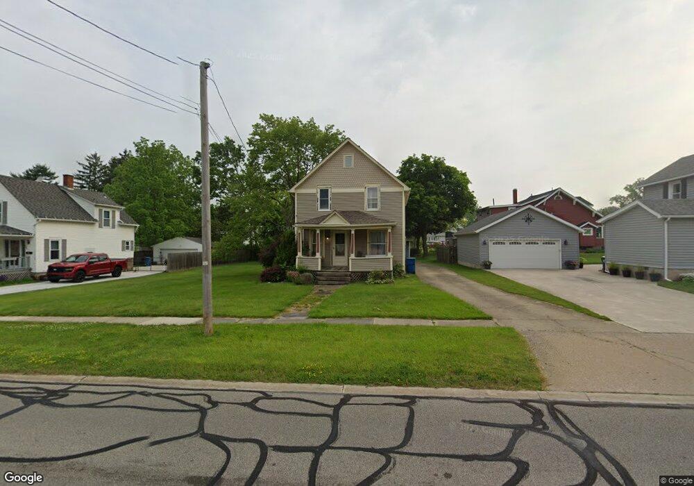
581 Elyria Ave Amherst, OH 44001
Estimated Value: $170,000 - $206,000
3
Beds
1
Bath
1,232
Sq Ft
$156/Sq Ft
Est. Value
About This Home
This home is located at 581 Elyria Ave, Amherst, OH 44001 and is currently estimated at $192,798, approximately $156 per square foot. 581 Elyria Ave is a home located in Lorain County with nearby schools including Powers Elementary School, Walter G. Nord Middle School, and Amherst Junior High School.
Ownership History
Date
Name
Owned For
Owner Type
Purchase Details
Closed on
Jul 1, 2025
Sold by
Krejci Elizabeth D
Bought by
Krejci Gary A
Current Estimated Value
Purchase Details
Closed on
Jun 26, 1996
Sold by
Rosebeck
Bought by
Krejci Gary A and Krejci Elizabeth
Home Financials for this Owner
Home Financials are based on the most recent Mortgage that was taken out on this home.
Original Mortgage
$90,000
Interest Rate
7.63%
Mortgage Type
New Conventional
Create a Home Valuation Report for This Property
The Home Valuation Report is an in-depth analysis detailing your home's value as well as a comparison with similar homes in the area
Home Values in the Area
Average Home Value in this Area
Purchase History
| Date | Buyer | Sale Price | Title Company |
|---|---|---|---|
| Krejci Gary A | -- | None Listed On Document | |
| Krejci Gary A | $100,000 | -- |
Source: Public Records
Mortgage History
| Date | Status | Borrower | Loan Amount |
|---|---|---|---|
| Previous Owner | Krejci Gary A | $90,000 |
Source: Public Records
Tax History Compared to Growth
Tax History
| Year | Tax Paid | Tax Assessment Tax Assessment Total Assessment is a certain percentage of the fair market value that is determined by local assessors to be the total taxable value of land and additions on the property. | Land | Improvement |
|---|---|---|---|---|
| 2024 | $1,972 | $48,836 | $17,448 | $31,388 |
| 2023 | $1,935 | $40,383 | $16,342 | $24,042 |
| 2022 | $1,855 | $40,383 | $16,342 | $24,042 |
| 2021 | $1,860 | $40,383 | $16,342 | $24,042 |
| 2020 | $1,777 | $34,250 | $13,860 | $20,390 |
| 2019 | $1,741 | $34,250 | $13,860 | $20,390 |
| 2018 | $1,549 | $34,250 | $13,860 | $20,390 |
| 2017 | $1,348 | $24,770 | $11,750 | $13,020 |
| 2016 | $1,359 | $24,770 | $11,750 | $13,020 |
| 2015 | $1,352 | $24,770 | $11,750 | $13,020 |
| 2014 | $1,246 | $22,730 | $10,780 | $11,950 |
| 2013 | $1,250 | $22,730 | $10,780 | $11,950 |
Source: Public Records
Map
Nearby Homes
- 611 West St
- 472 Sunset Dr
- 495 Church St
- 653 Brennan Dr
- 661 Tenney Ave
- 2176 Myla Way
- V/L Middle Ridge Rd
- 930 S Main St
- 318 Buttermere Ln
- 133 Ambleside Way
- 953 Longitude Ln
- 133 Forest St
- 0 Middle Ridge Rd Unit 5102632
- 812 Bearing Ct
- 772 Shadow Creek Trail
- 335 Copper Creek
- 394 Long St
- 248 Brandt Ave
- 0 Stonebridge Dr
- 7475 S Dewey Rd