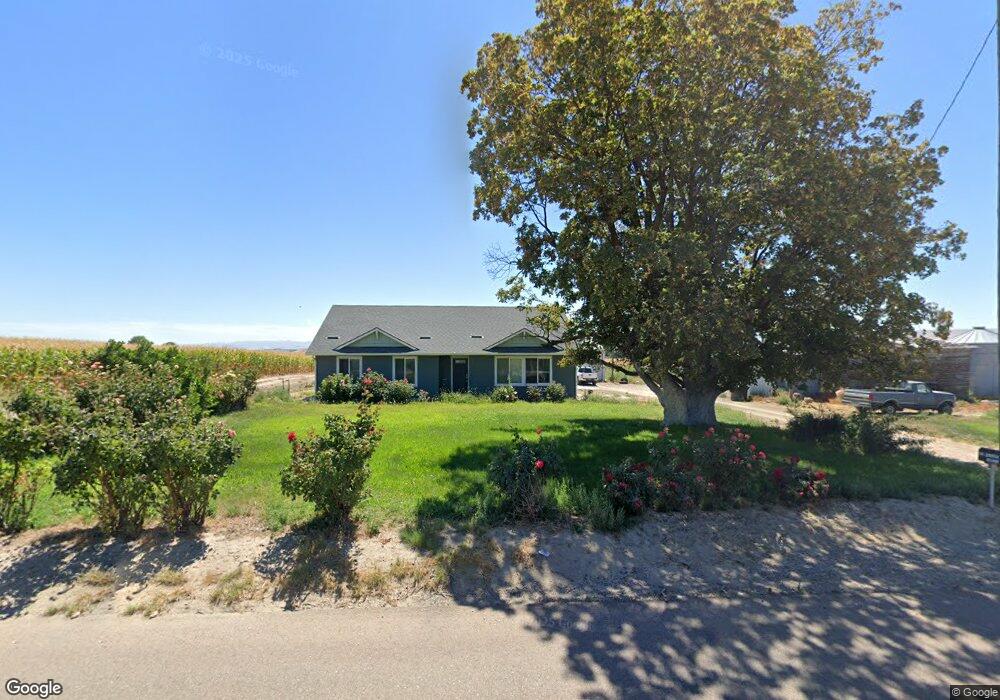
581 Pheasant Rd Adrian, OR 97901
Estimated Value: $698,162
2
Beds
1
Bath
1,715
Sq Ft
$407/Sq Ft
Est. Value
About This Home
This home is located at 581 Pheasant Rd, Adrian, OR 97901 and is currently estimated at $698,162, approximately $407 per square foot. 581 Pheasant Rd is a home located in Malheur County with nearby schools including Adrian Elementary School and Adrian High School.
Ownership History
Date
Name
Owned For
Owner Type
Purchase Details
Closed on
Jan 23, 2024
Sold by
Molt Dennis E and Bailey Victoria
Bought by
Sorrell David
Current Estimated Value
Home Financials for this Owner
Home Financials are based on the most recent Mortgage that was taken out on this home.
Original Mortgage
$805,000
Outstanding Balance
$781,406
Interest Rate
6.95%
Mortgage Type
New Conventional
Estimated Equity
-$83,244
Purchase Details
Closed on
Feb 3, 2023
Sold by
Bailey Victoria J
Bought by
Molt Dennis E
Create a Home Valuation Report for This Property
The Home Valuation Report is an in-depth analysis detailing your home's value as well as a comparison with similar homes in the area
Purchase History
| Date | Buyer | Sale Price | Title Company |
|---|---|---|---|
| Sorrell David | $700,000 | Amerititle | |
| Molt Dennis E | -- | -- | |
| Bailey Victoria J | -- | -- |
Source: Public Records
Mortgage History
| Date | Status | Borrower | Loan Amount |
|---|---|---|---|
| Open | Sorrell David | $805,000 |
Source: Public Records
Tax History
| Year | Tax Paid | Tax Assessment Tax Assessment Total Assessment is a certain percentage of the fair market value that is determined by local assessors to be the total taxable value of land and additions on the property. | Land | Improvement |
|---|---|---|---|---|
| 2025 | $2,212 | $201,104 | $39,044 | $162,060 |
| 2024 | $2,241 | $195,449 | $38,109 | $157,340 |
| 2023 | $2,050 | $189,895 | $37,137 | $152,758 |
| 2022 | $1,928 | $184,501 | $36,192 | $148,309 |
| 2021 | $1,994 | $179,019 | $35,029 | $143,990 |
| 2020 | $1,582 | $141,924 | $34,192 | $107,732 |
| 2019 | $853 | $72,322 | $33,292 | $39,030 |
| 2018 | $780 | $65,034 | $32,504 | $32,530 |
| 2017 | $743 | $64,269 | $31,739 | $32,530 |
| 2016 | $764 | $63,526 | $30,996 | $32,530 |
| 2015 | $632 | $53,277 | $28,727 | $24,550 |
| 2014 | $657 | $54,109 | $29,559 | $24,550 |
Source: Public Records
Map
Nearby Homes
- TBD Monte Rd
- Lot 2B Clydesdale Ln
- Lot 3B Drum Ln
- Lot 5A Drum Ln
- 4.8acTBD Chips Ln
- 1964 River Rd
- 00 Peckham Rd
- 26635 Pioneer Ln
- 23743 Stephen Ln
- 26915 Chips Ln
- 20383 Riverpoint Ln
- 646 Overstreet Rd
- 0 Riverpoint Ln
- 0 Tbd Peckham Rd
- Rd
- 0 Rodeo Ln
- 830 Snively Gulch Rd
- TBD Snively Gulch Rd
- 0 Tbd Stephen Ln
- 887 Overstreet Rd
- 1899 Cassia Rd
- 562 Pheasant Rd
- 1885 Stateline Rd
- 23076 State Line Rd
- 632 Pheasant Rd
- 1859 Stateline Rd
- 627 Foxtail Rd
- 1851 Stateline Rd
- 22704 State Line Rd
- 307 Oregon St
- 203 High St
- 509 Holly Ln
- 508 Holly Ln
- 630 Foxtail Rd
- 0 Foxtail Rd
- 818 Primrose Rd
- 1975 Cassia Rd
- 561 Maulsing Rd
- 561 Maulsing Rd
- 23742 State Line Rd
Your Personal Tour Guide
Ask me questions while you tour the home.