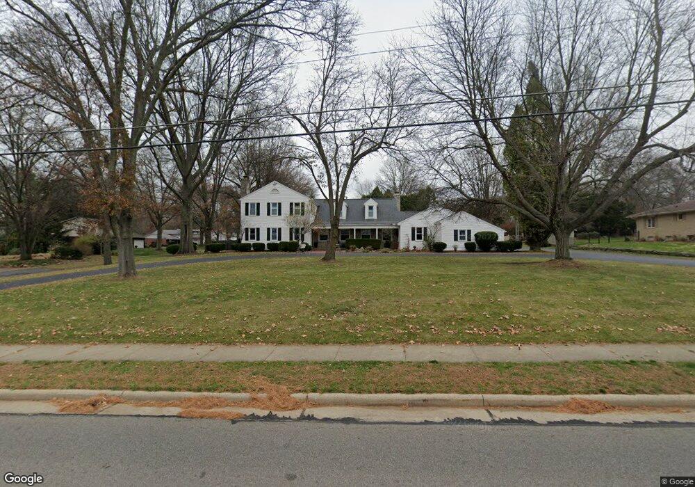
581 W Wayne Ave Wooster, OH 44691
Estimated Value: $457,000 - $580,000
4
Beds
3
Baths
3,168
Sq Ft
$164/Sq Ft
Est. Value
About This Home
This home is located at 581 W Wayne Ave, Wooster, OH 44691 and is currently estimated at $519,958, approximately $164 per square foot. 581 W Wayne Ave is a home located in Wayne County with nearby schools including Parkview Elementary School, Edgewood Middle School, and Wooster High School.
Ownership History
Date
Name
Owned For
Owner Type
Purchase Details
Closed on
Jul 15, 2019
Sold by
Mccord John W and Mccord Laura E
Bought by
Eversolle Thomas Brandon J and Gray Thomas Jara L
Current Estimated Value
Home Financials for this Owner
Home Financials are based on the most recent Mortgage that was taken out on this home.
Original Mortgage
$286,800
Outstanding Balance
$251,262
Interest Rate
3.82%
Mortgage Type
New Conventional
Estimated Equity
$268,696
Purchase Details
Closed on
Apr 10, 2012
Sold by
Mccord John W and Mccord Laura E
Bought by
Mccord John W and Mccord Laura E
Purchase Details
Closed on
Jul 30, 1993
Sold by
Meehan Joseph G and Meehan Anne M
Bought by
Mccord John W and Mccord Laura E
Create a Home Valuation Report for This Property
The Home Valuation Report is an in-depth analysis detailing your home's value as well as a comparison with similar homes in the area
Home Values in the Area
Average Home Value in this Area
Purchase History
| Date | Buyer | Sale Price | Title Company |
|---|---|---|---|
| Eversolle Thomas Brandon J | $358,500 | Wayne County Title | |
| Mccord John W | -- | None Available | |
| Mccord John W | $265,000 | -- |
Source: Public Records
Mortgage History
| Date | Status | Borrower | Loan Amount |
|---|---|---|---|
| Open | Eversolle Thomas Brandon J | $286,800 |
Source: Public Records
Tax History
| Year | Tax Paid | Tax Assessment Tax Assessment Total Assessment is a certain percentage of the fair market value that is determined by local assessors to be the total taxable value of land and additions on the property. | Land | Improvement |
|---|---|---|---|---|
| 2024 | $6,443 | $155,420 | $25,770 | $129,650 |
| 2023 | $6,443 | $155,420 | $25,770 | $129,650 |
| 2022 | $6,127 | $117,740 | $19,520 | $98,220 |
| 2021 | $6,321 | $117,740 | $19,520 | $98,220 |
| 2020 | $5,992 | $117,740 | $19,520 | $98,220 |
| 2019 | $6,472 | $122,150 | $19,520 | $102,630 |
| 2018 | $5,764 | $108,470 | $19,520 | $88,950 |
| 2017 | $5,802 | $108,470 | $19,520 | $88,950 |
| 2016 | $5,982 | $104,230 | $19,520 | $84,710 |
| 2015 | $5,873 | $104,230 | $19,520 | $84,710 |
| 2014 | $5,876 | $104,230 | $19,520 | $84,710 |
| 2013 | $6,062 | $106,480 | $21,870 | $84,610 |
Source: Public Records
Map
Nearby Homes
- 851 Park Blvd
- 1117 Quinby Ave
- 211 Oakley Rd
- 1047 Ashwood Dr
- 801 & 803 Colony Ct
- 972 Carriage Ln
- 814 N Bever St
- 869 Meadow Ln
- 835 Marilyn Dr
- 134 E Bowman St Unit 1/2
- 1942 Fisher Dr
- 1704 Carlin Trail
- 1627 Carlin Trail
- 1643 Carlin Trail
- 534 N Buckeye St
- 230 Clark Ave
- 2011 Burbank Rd
- 216 Ihrig Ave
- 317 Ihrig Ave
- 423 N Market St
- 1471 Saunders Dr
- 515 W Wayne Ave
- 615 W Wayne Ave
- 1470 Saunders Dr
- 1485 Saunders Dr
- 1470 Morgan St
- 1484 Saunders Dr
- 1497 Saunders Dr
- 637 W Wayne Ave
- 1488 Morgan St
- 1498 Saunders Dr
- 1479 Ruth Cir
- 435 W Wayne Ave
- 1511 Saunders Dr
- 1502 Morgan St
- 1449 Arthur Dr
- 1467 Morgan St
- 1512 Saunders Dr
- 1483 Morgan St
- 1485 Ruth Cir
Your Personal Tour Guide
Ask me questions while you tour the home.