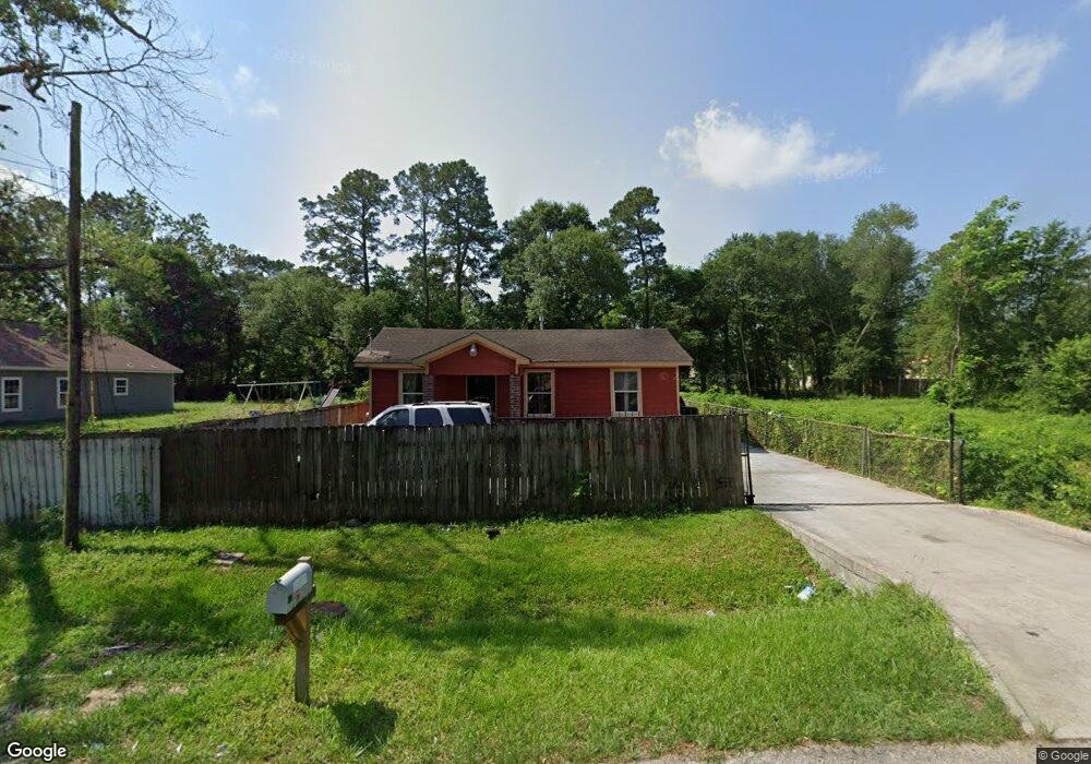
5812 Pate Rd Houston, TX 77016
East Little York NeighborhoodEstimated Value: $124,353 - $181,000
1
Bed
1
Bath
1,110
Sq Ft
$142/Sq Ft
Est. Value
About This Home
This home is located at 5812 Pate Rd, Houston, TX 77016 and is currently estimated at $158,088, approximately $142 per square foot. 5812 Pate Rd is a home located in Harris County with nearby schools including Shadydale Elementary School, Forest Brook Middle, and North Forest High School.
Ownership History
Date
Name
Owned For
Owner Type
Purchase Details
Closed on
Aug 11, 2022
Sold by
Imelda Cruz
Bought by
Rodriguez Gaudelio Hernandez and Olvera Lucidalia Vazquez
Current Estimated Value
Purchase Details
Closed on
Oct 15, 2009
Sold by
Cruz Inocencio and Cruz Angelica
Bought by
Cruz Imelda E
Purchase Details
Closed on
May 17, 2004
Sold by
Moreno Liborio D and Moreno Maria R
Bought by
Cruz Inocencio and Cruz Angelica
Purchase Details
Closed on
Mar 4, 2003
Sold by
Thompson Alvin
Bought by
Moreno Liborio D
Purchase Details
Closed on
Oct 25, 2002
Sold by
Thompson Alvin
Bought by
Jones Junius
Create a Home Valuation Report for This Property
The Home Valuation Report is an in-depth analysis detailing your home's value as well as a comparison with similar homes in the area
Home Values in the Area
Average Home Value in this Area
Purchase History
| Date | Buyer | Sale Price | Title Company |
|---|---|---|---|
| Rodriguez Gaudelio Hernandez | -- | None Listed On Document | |
| Cruz Imelda E | -- | None Available | |
| Cruz Inocencio | -- | -- | |
| Moreno Liborio D | $3,600 | -- | |
| Jones Junius | -- | -- |
Source: Public Records
Tax History Compared to Growth
Tax History
| Year | Tax Paid | Tax Assessment Tax Assessment Total Assessment is a certain percentage of the fair market value that is determined by local assessors to be the total taxable value of land and additions on the property. | Land | Improvement |
|---|---|---|---|---|
| 2025 | $1,945 | $101,064 | $55,451 | $45,613 |
| 2024 | $1,945 | $92,975 | $48,296 | $44,679 |
| 2023 | $1,658 | $82,300 | $30,409 | $51,891 |
| 2022 | $1,608 | $73,036 | $30,409 | $42,627 |
| 2021 | $1,133 | $61,412 | $21,465 | $39,947 |
| 2020 | $1,071 | $52,290 | $21,465 | $30,825 |
| 2019 | $1,017 | $43,118 | $15,026 | $28,092 |
| 2018 | $440 | $36,539 | $12,521 | $24,018 |
| 2017 | $874 | $36,539 | $12,521 | $24,018 |
| 2016 | $795 | $31,430 | $7,513 | $23,917 |
| 2015 | $468 | $31,430 | $7,513 | $23,917 |
| 2014 | $468 | $31,430 | $7,513 | $23,917 |
Source: Public Records
Map
Nearby Homes
- 5914 Breland St
- 5203 Mayle St
- 5125 Mayle St
- 5418 Parker Rd
- 5621 Haywood St
- 5713 Rietta St
- 5715 Rietta St
- 9711 Bertwood St
- 9838 Camay Dr
- 4708 Antha St
- 9603 Bertwood St
- 7902 S Lockwood Dr
- 9705 Peachtree St
- 5413 Glen Nook Dr
- 0 Haywood St Unit 63273227
- 7631 Hirsch Rd
- 6206 Antha St
- 9421 Sandra St
- 9410 Dandy St
- 6001 Bretshire Dr
- 5816 Pate Rd
- 5826 Pate Rd
- 5706 Pate Rd
- 5830 Pate Rd
- 5809 Pate Rd
- 5709 Pate Rd
- 5809 Breland St
- 5813 Pate Rd
- 5805 Breland St
- 5813 Breland St
- 5813 Breland St Unit B
- 5901 Pate Rd
- 5713 Breland St
- 5907 Breland St
- 5912 Pate Rd
- 5702 Pate Rd
- 5711 Breland St Unit b
- 5711 Breland St Unit A
- 5711 Breland St
- 5709 Breland St