Estimated Value: $603,109 - $644,000
3
Beds
2
Baths
3,925
Sq Ft
$159/Sq Ft
Est. Value
About This Home
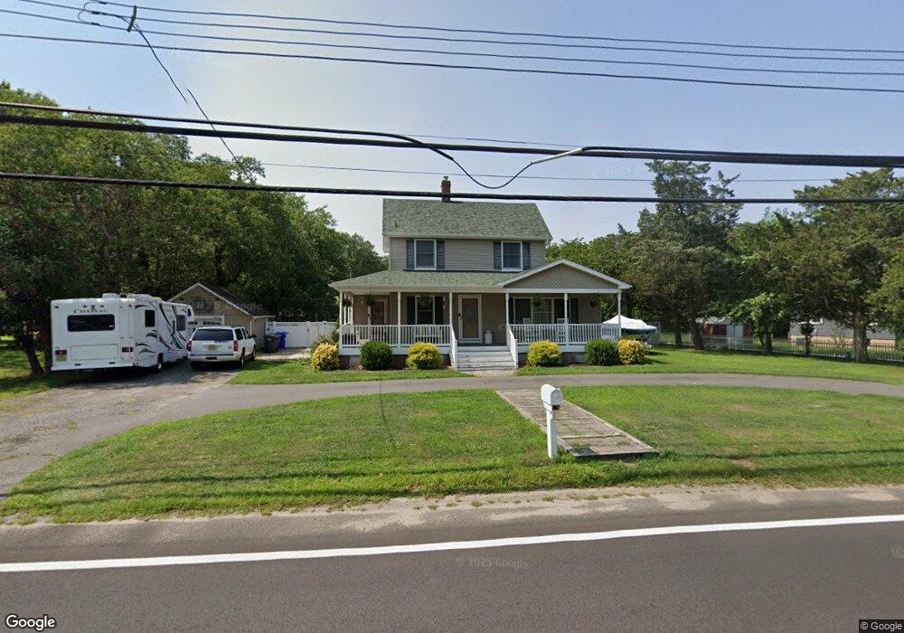
This home is located at 582 Adamston Rd, Brick, NJ 08723 and is currently estimated at $626,027, approximately $159 per square foot. 582 Adamston Rd is a home located in Ocean County with nearby schools including Osbornville Elementary School, Lake Riviera Middle School, and Brick Township High School.
Ownership History
Date
Name
Owned For
Owner Type
Purchase Details
Closed on
Jun 14, 2006
Sold by
Butelewicz Steven and Butelewicz Nora
Bought by
Rahn Mark and Rahn Melissa
Current Estimated Value
Home Financials for this Owner
Home Financials are based on the most recent Mortgage that was taken out on this home.
Original Mortgage
$44,000
Outstanding Balance
$27,877
Interest Rate
8%
Mortgage Type
Credit Line Revolving
Estimated Equity
$598,150
Purchase Details
Closed on
Mar 29, 2001
Sold by
Johnson Arthur
Bought by
Butelewicz Steven and Butelewicz Nora
Home Financials for this Owner
Home Financials are based on the most recent Mortgage that was taken out on this home.
Original Mortgage
$75,000
Interest Rate
7.05%
Create a Home Valuation Report for This Property
The Home Valuation Report is an in-depth analysis detailing your home's value as well as a comparison with similar homes in the area
Home Values in the Area
Average Home Value in this Area
Purchase History
| Date | Buyer | Sale Price | Title Company |
|---|---|---|---|
| Rahn Mark | $440,000 | Fidelity Natl Title Ins Co | |
| Butelewicz Steven | $102,245 | -- | |
| Butelewicz Steven | $102,245 | -- |
Source: Public Records
Mortgage History
| Date | Status | Borrower | Loan Amount |
|---|---|---|---|
| Open | Rahn Mark | $44,000 | |
| Previous Owner | Butelewicz Steven | $75,000 |
Source: Public Records
Tax History
| Year | Tax Paid | Tax Assessment Tax Assessment Total Assessment is a certain percentage of the fair market value that is determined by local assessors to be the total taxable value of land and additions on the property. | Land | Improvement |
|---|---|---|---|---|
| 2025 | $7,808 | $302,300 | $114,800 | $187,500 |
| 2024 | $7,421 | $302,300 | $114,800 | $187,500 |
Source: Public Records
Map
Nearby Homes
- 463 Mamie Dr
- 22 Evelyn Ct
- 299 Huppert Dr
- 440 Drum Point Rd
- 307 Drum Point Rd
- 9 Bayberry Ave
- 484 Bara St
- 48 Birch Dr
- 0 Mantoloking Rd Unit 11584872
- 72 Baywood Blvd
- 10 Riverside Dr W
- 578 Kingfisher Cir
- 638 Ivanhoe Rd
- 580 Kingfisher Cir
- 474 Burnt Bark Rd
- 592 Kingfisher Cir
- 35 Hampton Rd
- 19 Moholo Ct Unit 19
- 84 Woodland Dr
- 56 Tall Timber Dr
- 578 Adamston Rd
- 586 Adamston Rd
- 581 Adamston Rd
- 577 Reedy Dr
- 574 Adamston Rd
- 585 Adamston Rd
- 590 Adamston Rd
- 572 Adamston Rd
- 390 Reedy Dr
- 589 Adamston Rd
- 33 N Unit Pier
- 118 Avenue Unit Pier
- 19 N Unit Pier
- 44 N Unit Pier
- 30 N Unit Pier
- 6 N Unit Pier
- 531 Whitethorn Ct
- 500 S Vanada Dr
- 594 Adamston Rd
- 582 Allen Rd
Your Personal Tour Guide
Ask me questions while you tour the home.