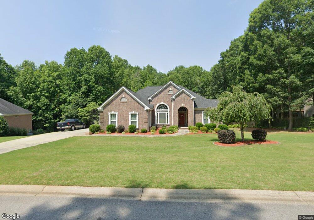
582 Southampton Cir Hoschton, GA 30548
Estimated Value: $449,000 - $579,000
3
Beds
3
Baths
2,001
Sq Ft
$256/Sq Ft
Est. Value
About This Home
This home is located at 582 Southampton Cir, Hoschton, GA 30548 and is currently estimated at $512,667, approximately $256 per square foot. 582 Southampton Cir is a home located in Jackson County with nearby schools including Gum Springs Elementary School, West Jackson Middle School, and Jackson County High School.
Ownership History
Date
Name
Owned For
Owner Type
Purchase Details
Closed on
Aug 24, 2009
Sold by
Byrant S J
Bought by
Brown William B
Current Estimated Value
Purchase Details
Closed on
Mar 17, 2005
Sold by
Maple Homes Inc
Bought by
Bryant S J and Bryant Kathleen C
Purchase Details
Closed on
Jul 20, 2004
Sold by
Liberty Crest Properties Inc
Bought by
Maple Homes Inc
Create a Home Valuation Report for This Property
The Home Valuation Report is an in-depth analysis detailing your home's value as well as a comparison with similar homes in the area
Home Values in the Area
Average Home Value in this Area
Purchase History
| Date | Buyer | Sale Price | Title Company |
|---|---|---|---|
| Brown William B | $220,000 | -- | |
| Bryant S J | $261,258 | -- | |
| Maple Homes Inc | $225,000 | -- |
Source: Public Records
Tax History Compared to Growth
Tax History
| Year | Tax Paid | Tax Assessment Tax Assessment Total Assessment is a certain percentage of the fair market value that is determined by local assessors to be the total taxable value of land and additions on the property. | Land | Improvement |
|---|---|---|---|---|
| 2024 | $3,239 | $153,000 | $20,480 | $132,520 |
| 2023 | $3,239 | $153,000 | $20,480 | $132,520 |
| 2022 | $2,997 | $129,200 | $20,480 | $108,720 |
| 2021 | $2,911 | $125,640 | $20,480 | $105,160 |
| 2020 | $2,583 | $108,560 | $20,480 | $88,080 |
| 2019 | $2,620 | $108,560 | $20,480 | $88,080 |
| 2018 | $2,514 | $104,440 | $20,480 | $83,960 |
| 2017 | $2,308 | $98,107 | $20,480 | $77,627 |
| 2016 | $2,179 | $94,044 | $20,480 | $73,564 |
| 2015 | $1,819 | $83,564 | $10,000 | $73,564 |
| 2014 | $1,527 | $76,867 | $10,000 | $66,867 |
| 2013 | -- | $76,866 | $10,000 | $66,866 |
Source: Public Records
Map
Nearby Homes
- 148 Montvale Dr
- 161 Southampton Cir
- 25 Wicklow Ct
- 225 Wicklow Ct
- 649 Prescott Point
- 91 Biltmore Place
- 1049 Amber Waves Ave
- 6494 Georgia 124
- 4248 Links Blvd
- 4502 Links Blvd
- 4300 Links Blvd
- 4306 Links Blvd
- 4341 Links Blvd
- The Hickory A Plan at Wehunt Meadows
- The Glenwood D Plan at Wehunt Meadows
- The Harrison G Plan at Wehunt Meadows
- The Ash C Plan at Wehunt Meadows
- 341 Grand Wehunt Dr
- 608 Southampton Cir
- 558 Southampton Cir
- 558 Southampton Cir Unit 20
- 23 Montvale Dr
- 534 Southampton Cir
- 630 Southampton Cir
- 547 Southampton Cir
- 174 Dumar Ln
- 654 Southampton Cir
- 510 Southampton Cir
- 81 Montvale Dr
- 169 Dumar Ln
- 52 Montvale Dr
- 168 Dumar Ln
- 499 Southampton Cir
- 28 Montvale Dr Unit 92
- 28 Montvale Dr
- 0 Walnut Dr 0
- 233 Walnut Ridge
- 233 Walnut Ridge