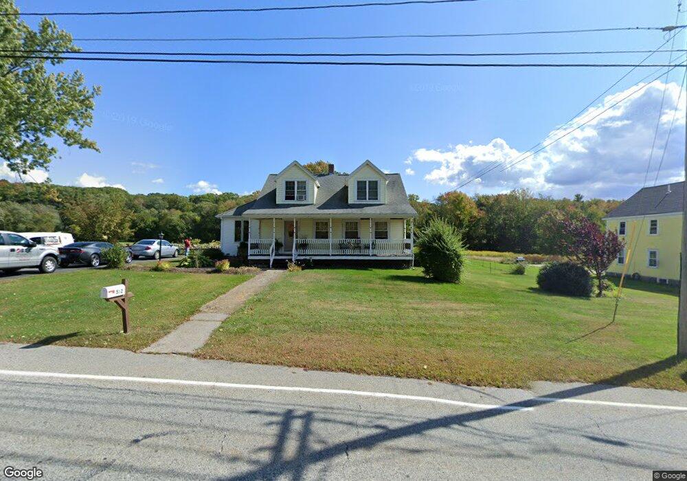
582 W Hartford Ave Uxbridge, MA 01569
Estimated Value: $451,000 - $564,000
3
Beds
2
Baths
1,509
Sq Ft
$338/Sq Ft
Est. Value
About This Home
This home is located at 582 W Hartford Ave, Uxbridge, MA 01569 and is currently estimated at $510,792, approximately $338 per square foot. 582 W Hartford Ave is a home located in Worcester County with nearby schools including Uxbridge High School and Our Lady of the Valley Regional School.
Ownership History
Date
Name
Owned For
Owner Type
Purchase Details
Closed on
Dec 13, 1996
Sold by
Christiansen Mary A
Bought by
Reardon James and Reardon Maria
Current Estimated Value
Home Financials for this Owner
Home Financials are based on the most recent Mortgage that was taken out on this home.
Original Mortgage
$113,900
Interest Rate
7.75%
Mortgage Type
Purchase Money Mortgage
Create a Home Valuation Report for This Property
The Home Valuation Report is an in-depth analysis detailing your home's value as well as a comparison with similar homes in the area
Home Values in the Area
Average Home Value in this Area
Purchase History
| Date | Buyer | Sale Price | Title Company |
|---|---|---|---|
| Reardon James | $119,900 | -- |
Source: Public Records
Mortgage History
| Date | Status | Borrower | Loan Amount |
|---|---|---|---|
| Open | Reardon James | $149,500 | |
| Closed | Reardon James | $119,700 | |
| Closed | Reardon James | $113,900 |
Source: Public Records
Tax History Compared to Growth
Tax History
| Year | Tax Paid | Tax Assessment Tax Assessment Total Assessment is a certain percentage of the fair market value that is determined by local assessors to be the total taxable value of land and additions on the property. | Land | Improvement |
|---|---|---|---|---|
| 2025 | $51 | $390,200 | $132,800 | $257,400 |
| 2024 | $4,740 | $366,900 | $121,700 | $245,200 |
| 2023 | $4,571 | $327,700 | $110,600 | $217,100 |
| 2022 | $4,269 | $281,600 | $100,300 | $181,300 |
| 2021 | $4,273 | $270,100 | $95,900 | $174,200 |
| 2020 | $4,229 | $252,600 | $99,600 | $153,000 |
| 2019 | $4,107 | $236,700 | $92,200 | $144,500 |
| 2018 | $3,795 | $221,000 | $92,200 | $128,800 |
| 2017 | $3,743 | $220,700 | $86,100 | $134,600 |
| 2016 | $3,621 | $206,100 | $84,500 | $121,600 |
| 2015 | $3,550 | $204,000 | $84,500 | $119,500 |
Source: Public Records
Map
Nearby Homes
- 103 Uxbridge St
- 138 Mantell Rd
- 145 Mantell Rd
- 169 Mantell Rd
- 137 Mantell Rd
- 60 Tyler Dr
- 33 Summerfield Dr Unit 33
- 153 Davis St
- 68 Lackey Dam Rd
- 2 C St
- 7 Jefferson Ct Unit 7
- 26 Bayliss Way
- 22 Bayliss Way
- 405 West St
- 3 Bayliss Way
- Layla Plan at Pine Ridge
- Ashley Plan at Pine Ridge
- Lily Plan at Pine Ridge
- Brooklyn Plan at Pine Ridge
- Tucker Plan at Pine Ridge
- 588 Hartford Ave W
- 588 Hartford Ave W Unit 2nd flr
- 591 Hartford Ave W
- 0 Hazel St
- 573 Hartford Ave W
- 643 Hazel St
- 1-4 West St
- 621 W Hartford Ave
- 625 Hartford Ave W
- 603 Hazel St
- 632 Hartford Ave W
- 38 West St
- 575 Hazel St
- 629 W Hartford Ave
- 35 West St
- 641 W Hartford Ave
- 644 Hartford Ave W
- 521 Hartford Ave W
- 511 W Hartford Ave
- 652 Hartford Ave W