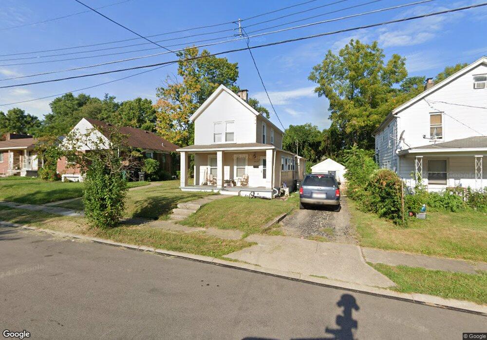
5827 Elsie Ave Cincinnati, OH 45224
College Hill NeighborhoodEstimated Value: $95,000 - $157,000
2
Beds
1
Bath
1,362
Sq Ft
$94/Sq Ft
Est. Value
About This Home
This home is located at 5827 Elsie Ave, Cincinnati, OH 45224 and is currently estimated at $127,800, approximately $93 per square foot. 5827 Elsie Ave is a home located in Hamilton County with nearby schools including Pleasant Hill Elementary School, Robert A. Taft Information Technology High School, and Western Hills High School.
Ownership History
Date
Name
Owned For
Owner Type
Purchase Details
Closed on
Nov 25, 2019
Sold by
Benchmark Property Consultants Llc
Bought by
Vb One Llc
Current Estimated Value
Purchase Details
Closed on
Dec 23, 1997
Sold by
Dressman Robert A
Bought by
5827 Elsie Avenue Land Trust
Purchase Details
Closed on
Aug 23, 1996
Sold by
Dickerson Clemmie and Tubbs Mamie D
Bought by
Dressman Robert A
Create a Home Valuation Report for This Property
The Home Valuation Report is an in-depth analysis detailing your home's value as well as a comparison with similar homes in the area
Home Values in the Area
Average Home Value in this Area
Purchase History
| Date | Buyer | Sale Price | Title Company |
|---|---|---|---|
| Vb One Llc | $62,500 | None Available | |
| Benchmark Property Consultants Llc | $56,000 | None Available | |
| 5827 Elsie Avenue Land Trust | -- | -- | |
| Dressman Robert A | $31,300 | -- |
Source: Public Records
Tax History
| Year | Tax Paid | Tax Assessment Tax Assessment Total Assessment is a certain percentage of the fair market value that is determined by local assessors to be the total taxable value of land and additions on the property. | Land | Improvement |
|---|---|---|---|---|
| 2025 | $2,182 | $34,223 | $9,898 | $24,325 |
| 2023 | $2,183 | $34,223 | $9,898 | $24,325 |
| 2022 | $1,555 | $21,876 | $8,061 | $13,815 |
| 2021 | $1,524 | $21,876 | $8,061 | $13,815 |
| 2020 | $1,679 | $21,876 | $8,061 | $13,815 |
| 2019 | $1,124 | $14,599 | $7,070 | $7,529 |
| 2018 | $1,125 | $14,599 | $7,070 | $7,529 |
| 2017 | $1,083 | $14,599 | $7,070 | $7,529 |
| 2016 | $393 | $5,093 | $4,722 | $371 |
| 2015 | $352 | $5,093 | $4,722 | $371 |
| 2014 | $354 | $5,093 | $4,722 | $371 |
| 2013 | $371 | $5,251 | $4,869 | $382 |
Source: Public Records
Map
Nearby Homes
- 1190 West Way
- 1166 Groesbeck Rd
- 5945 Leffingwell Ave
- 5940 Kenneth Ave
- 1217 Groesbeck Rd
- 1197 Toluca Ct
- 5679 Folchi Dr
- 6045 Tahiti Dr
- 6101 Capri Dr
- 6000 Capri Dr
- 6071 Lantana Ave
- 5825 Salvia Ave
- 5974 Sunridge Dr
- 6024 Sunridge Dr
- 939 Venetian Terrace
- 875 Venetian Terrace
- 1620 Linden Dr
- 6145 Sunridge Dr
- 5510 Hamilton Ave
- 1491 Reid Ave
- 5823 Elsie Ave
- 5831 Elsie Ave
- 5819 Elsie Ave
- 5835 Elsie Ave
- 1150 N Lynnebrook Dr
- 1154 N Lynnebrook Dr
- 1133 N Lynnebrook Dr
- 5839 Elsie Ave
- 1137 S Lynnebrook Dr
- 1160 N Lynnebrook Dr
- 1141 S Lynnebrook Dr
- 5828 Elsie Ave
- 5815 Elsie Ave
- 5824 Elsie Ave
- 5836 Elsie Ave
- 5818 Elsie Ave
- 1164 N Lynnebrook Dr
- 5814 Elsie Ave
- 5845 Elsie Ave
- 1145 Cedar Ave
Your Personal Tour Guide
Ask me questions while you tour the home.