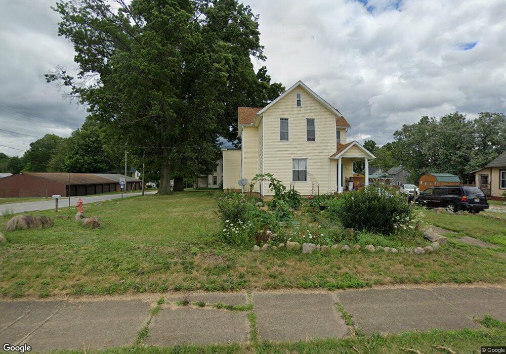
583 W Ely St Alliance, OH 44601
Estimated Value: $115,000 - $154,000
3
Beds
2
Baths
1,754
Sq Ft
$74/Sq Ft
Est. Value
About This Home
This home is located at 583 W Ely St, Alliance, OH 44601 and is currently estimated at $130,608, approximately $74 per square foot. 583 W Ely St is a home located in Stark County with nearby schools including Alliance Early Learning School, Alliance Intermediate School at Northside, and Alliance Middle School.
Ownership History
Date
Name
Owned For
Owner Type
Purchase Details
Closed on
Dec 13, 2024
Sold by
Church Wayne R
Bought by
Nelson Kari Lynne
Current Estimated Value
Purchase Details
Closed on
Apr 18, 2018
Sold by
Church Holly A
Bought by
Church Wayne R
Purchase Details
Closed on
Sep 28, 1988
Create a Home Valuation Report for This Property
The Home Valuation Report is an in-depth analysis detailing your home's value as well as a comparison with similar homes in the area
Home Values in the Area
Average Home Value in this Area
Purchase History
| Date | Buyer | Sale Price | Title Company |
|---|---|---|---|
| Nelson Kari Lynne | -- | None Listed On Document | |
| Nelson Kari Lynne | -- | None Listed On Document | |
| Church Wayne R | -- | None Available | |
| -- | $12,500 | -- |
Source: Public Records
Tax History
| Year | Tax Paid | Tax Assessment Tax Assessment Total Assessment is a certain percentage of the fair market value that is determined by local assessors to be the total taxable value of land and additions on the property. | Land | Improvement |
|---|---|---|---|---|
| 2025 | $899 | $42,070 | $7,280 | $34,790 |
| 2024 | $2,244 | $42,070 | $7,280 | $34,790 |
| 2023 | $2,186 | $25,760 | $7,210 | $18,550 |
| 2022 | $1,067 | $25,760 | $7,210 | $18,550 |
| 2021 | $1,270 | $25,760 | $7,210 | $18,550 |
| 2020 | $976 | $21,950 | $6,270 | $15,680 |
| 2019 | $915 | $21,950 | $6,270 | $15,680 |
| 2018 | $968 | $21,950 | $6,270 | $15,680 |
| 2017 | $759 | $16,910 | $4,240 | $12,670 |
| 2016 | $713 | $15,760 | $4,240 | $11,520 |
| 2015 | $81 | $12,290 | $4,240 | $8,050 |
| 2014 | $630 | $13,130 | $4,520 | $8,610 |
| 2013 | $314 | $13,130 | $4,520 | $8,610 |
Source: Public Records
Map
Nearby Homes
- 33 S Lincoln Ave
- 118 S Mckinley Ave
- 343 W Columbia St
- 264 W Market St
- 171 1/2 W Main St
- 160 Bonnieview Ave
- 432 Johnson Ave
- 347 Buckeye Ave
- 717 Garfield Ave
- 163 W Market St
- 550 Johnson Ave
- 479 W High St
- 319 W Oxford St
- 505 N Union Ave
- 000 Meadowbrook Ave
- 535 S Mckinley Ave
- 228 W Oxford St
- 233 W Cambridge St
- 62 E Market St
- 0 Meadowbrook Ave
- 335 N Rockhill Ave
- 304 N Rockhill Ave
- 575 W Ely St
- 351 N Rockhill Ave
- 588 W Harrison St
- 554 W Harrison St
- 354 N Rockhill Ave
- 545 W Ely St
- 360 N Rockhill Ave
- 544 W Harrison St
- 522 W Harrison St
- 406 N Rockhill Ave
- 510 W Harrison St
- 545 W Harrison St
- 414 N Rockhill Ave
- 414 N Rockhill Ave
- 567 W Harrison St
- 535 W Harrison St
- 499 W Ely St
- 498 W Harrison St
Your Personal Tour Guide
Ask me questions while you tour the home.