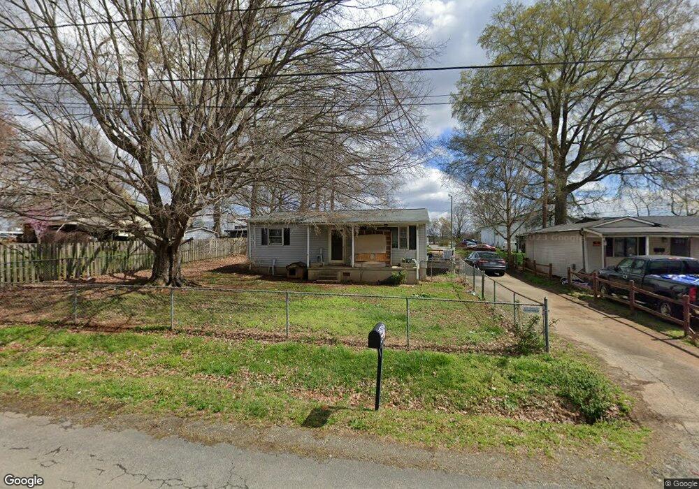
5835 Bertie Ave Salisbury, NC 28147
Estimated Value: $145,000 - $194,000
--
Bed
--
Bath
884
Sq Ft
$190/Sq Ft
Est. Value
About This Home
This home is located at 5835 Bertie Ave, Salisbury, NC 28147 and is currently estimated at $168,207, approximately $190 per square foot. 5835 Bertie Ave is a home with nearby schools including Knollwood Elementary School, Southeast Middle School, and Jesse C Carson High School.
Ownership History
Date
Name
Owned For
Owner Type
Purchase Details
Closed on
Apr 16, 2007
Sold by
Sheppard Thomas K and Sheppard Angela B
Bought by
Mike Reid Enterprises Inc
Current Estimated Value
Purchase Details
Closed on
Oct 31, 2006
Sold by
Evers Mary A and Evers Ashley D
Bought by
Sheppard Thomas K and Adb Properties
Home Financials for this Owner
Home Financials are based on the most recent Mortgage that was taken out on this home.
Original Mortgage
$41,493
Interest Rate
6.39%
Mortgage Type
Unknown
Purchase Details
Closed on
Jun 2, 2005
Sold by
Evers Mary A and Evers Ashley D
Bought by
Potts Nancy Evers and Evers Ashley D
Create a Home Valuation Report for This Property
The Home Valuation Report is an in-depth analysis detailing your home's value as well as a comparison with similar homes in the area
Home Values in the Area
Average Home Value in this Area
Purchase History
| Date | Buyer | Sale Price | Title Company |
|---|---|---|---|
| Mike Reid Enterprises Inc | $55,000 | None Available | |
| Sheppard Thomas K | $44,000 | None Available | |
| Potts Nancy Evers | -- | -- | |
| Potts Nancy Evers | -- | -- |
Source: Public Records
Mortgage History
| Date | Status | Borrower | Loan Amount |
|---|---|---|---|
| Previous Owner | Sheppard Thomas K | $41,493 |
Source: Public Records
Tax History Compared to Growth
Tax History
| Year | Tax Paid | Tax Assessment Tax Assessment Total Assessment is a certain percentage of the fair market value that is determined by local assessors to be the total taxable value of land and additions on the property. | Land | Improvement |
|---|---|---|---|---|
| 2025 | $867 | $128,035 | $47,438 | $80,597 |
| 2024 | $867 | $128,035 | $47,438 | $80,597 |
| 2023 | $867 | $128,035 | $47,438 | $80,597 |
| 2022 | $713 | $94,446 | $47,438 | $47,008 |
| 2021 | $706 | $94,446 | $47,438 | $47,008 |
| 2020 | $706 | $94,446 | $47,438 | $47,008 |
| 2019 | $706 | $94,446 | $47,438 | $47,008 |
| 2018 | $662 | $89,354 | $47,437 | $41,917 |
Source: Public Records
Map
Nearby Homes
- 0 Swink Ave
- 6000 S Main St
- 355 Swink Ave
- 6115 Southern Ln
- 6255 Meadow Ln
- 179 Spring Oak Dr
- 00 Neelytown Rd
- 0 Brookfield Cir Unit CAR4292885
- 0 Ed Weavers Rd
- 1352 Eva Ln
- 1675 N Main St
- 1140 Peeler Rd
- 400 Black Bear St Unit 154p
- 130 Lois Ln
- TA3000 Plan at Kensington
- Hudson Plan at Kensington
- Devin Plan at Kensington
- Bayside Plan at Kensington
- TA4000 Plan at Kensington
- Kipling Plan at Kensington
- 5855 Bertie Ave
- 5850 Bertie Ave
- 5865 Bertie Ave
- 125 Roseman Rd
- 5860 Bertie Ave Unit H
- 5830 S Main St
- 115 Karri Ln
- 225 Roseman Rd
- 5850 S Main St
- 57 Bertie Ave
- 125 Karri Ln Unit H
- 5800 S Main St
- 5770 Bertie Ave
- 235 Roseman Rd
- 5910 S Main St
- 5815 S Main St
- 31 Roseman Rd
- 5755 Bertie Ave
- 5750 Bertie Ave
- 250 Roseman Rd