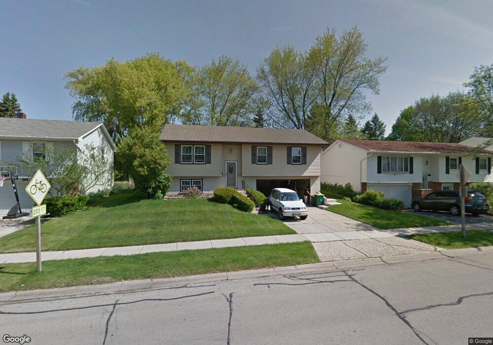
584 Bernard Dr Buffalo Grove, IL 60089
South Buffalo Grove NeighborhoodEstimated Value: $372,594 - $446,000
3
Beds
2
Baths
1,134
Sq Ft
$361/Sq Ft
Est. Value
About This Home
This home is located at 584 Bernard Dr, Buffalo Grove, IL 60089 and is currently estimated at $409,149, approximately $360 per square foot. 584 Bernard Dr is a home located in Cook County with nearby schools including Henry W Longfellow Elementary School, Cooper Middle School, and Buffalo Grove High School.
Ownership History
Date
Name
Owned For
Owner Type
Purchase Details
Closed on
Jun 22, 2007
Sold by
Politzki Siegfried J and Politzki Mary L
Bought by
Perez Alexander and Perez Leah E
Current Estimated Value
Home Financials for this Owner
Home Financials are based on the most recent Mortgage that was taken out on this home.
Original Mortgage
$277,200
Interest Rate
6.73%
Mortgage Type
Unknown
Create a Home Valuation Report for This Property
The Home Valuation Report is an in-depth analysis detailing your home's value as well as a comparison with similar homes in the area
Home Values in the Area
Average Home Value in this Area
Purchase History
| Date | Buyer | Sale Price | Title Company |
|---|---|---|---|
| Perez Alexander | $308,000 | Republic Title Co |
Source: Public Records
Mortgage History
| Date | Status | Borrower | Loan Amount |
|---|---|---|---|
| Previous Owner | Perez Alexander | $277,200 |
Source: Public Records
Tax History Compared to Growth
Tax History
| Year | Tax Paid | Tax Assessment Tax Assessment Total Assessment is a certain percentage of the fair market value that is determined by local assessors to be the total taxable value of land and additions on the property. | Land | Improvement |
|---|---|---|---|---|
| 2024 | $6,815 | $25,554 | $6,480 | $19,074 |
| 2023 | $6,815 | $25,554 | $6,480 | $19,074 |
| 2022 | $6,815 | $25,554 | $6,480 | $19,074 |
| 2021 | $6,920 | $22,918 | $4,140 | $18,778 |
| 2020 | $6,813 | $22,918 | $4,140 | $18,778 |
| 2019 | $6,805 | $25,408 | $4,140 | $21,268 |
| 2018 | $7,303 | $24,641 | $3,600 | $21,041 |
| 2017 | $7,189 | $24,641 | $3,600 | $21,041 |
| 2016 | $6,955 | $24,641 | $3,600 | $21,041 |
| 2015 | $6,218 | $20,927 | $3,060 | $17,867 |
| 2014 | $6,133 | $20,927 | $3,060 | $17,867 |
| 2013 | $5,651 | $20,927 | $3,060 | $17,867 |
Source: Public Records
Map
Nearby Homes
- 455 Mayfair Ln
- 310 Rosewood Ave
- 535 Estate Dr
- 665 Thornwood Dr
- 571 Estate Dr
- 234 Mohawk Trail
- 921 Bernard Dr
- 859 Beechwood Rd
- 813 Stradford Cir Unit 21B2
- 183 Saint Marys Pkwy
- 25 Crestview Terrace
- 820 Weidner Rd Unit 4013
- 820 Weidner Rd Unit 409
- 443 Diane Dr
- 98 Glendale Rd
- 720 Weidner Rd Unit 302
- 3451 N Carriageway Dr Unit 503
- 12 Oak Creek Dr Unit 2212
- 10 Old Oak Dr Unit 103
- 51 Old Oak Dr Unit 302
- 574 Bernard Dr
- 594 Bernard Dr
- 564 Bernard Dr
- 604 Bernard Dr
- 583 Bernard Dr
- 556 Bernard Dr
- 618 Bernard Dr
- 565 Bernard Dr
- 589 Elmwood Dr
- 588 Elmwood Dr
- 630 Bernard Dr
- 557 Bernard Dr
- 591 Elmwood Dr
- 401 White Pine Rd
- 545 Bernard Dr
- 600 Elmwood Dr
- 535 Bernard Dr
- 593 Elmwood Dr
- 425 White Pine Rd
- 345 Cottonwood Rd