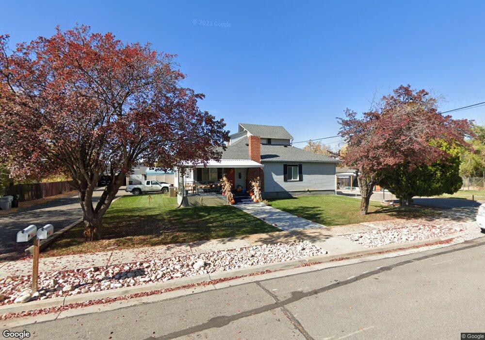
584 S 100 E Springville, UT 84663
Estimated Value: $588,000 - $699,000
10
Beds
5
Baths
3,770
Sq Ft
$171/Sq Ft
Est. Value
About This Home
This home is located at 584 S 100 E, Springville, UT 84663 and is currently estimated at $643,939, approximately $170 per square foot. 584 S 100 E is a home located in Utah County with nearby schools including Cherry Creek Elementary School, Springville Junior High School, and Springville High School.
Ownership History
Date
Name
Owned For
Owner Type
Purchase Details
Closed on
Dec 17, 2020
Sold by
Vanpatten Ray and Estate Of Daniel Ray Van Patte
Bought by
Vanpatten Krysta Alyssa and Vanpatten Van Patten
Current Estimated Value
Purchase Details
Closed on
Apr 26, 2016
Sold by
Vanpatten Donald Reed and Van Patten Daniel Ray
Bought by
Vanpatten Donald Reed and Van Patten Daniel Ray
Purchase Details
Closed on
Sep 10, 2009
Sold by
Vanpatten Blaine
Bought by
Vanpatten Baline and Van Patten Lily F
Create a Home Valuation Report for This Property
The Home Valuation Report is an in-depth analysis detailing your home's value as well as a comparison with similar homes in the area
Home Values in the Area
Average Home Value in this Area
Purchase History
| Date | Buyer | Sale Price | Title Company |
|---|---|---|---|
| Vanpatten Krysta Alyssa | -- | None Available | |
| Vanpatten Donald Reed | -- | None Available | |
| Vanpatten Baline | -- | None Available |
Source: Public Records
Tax History
| Year | Tax Paid | Tax Assessment Tax Assessment Total Assessment is a certain percentage of the fair market value that is determined by local assessors to be the total taxable value of land and additions on the property. | Land | Improvement |
|---|---|---|---|---|
| 2025 | $2,567 | $341,935 | -- | -- |
| 2024 | $2,567 | $263,010 | $0 | $0 |
| 2023 | $2,539 | $260,370 | $0 | $0 |
| 2022 | $2,383 | $239,965 | $0 | $0 |
| 2021 | $2,319 | $363,600 | $90,900 | $272,700 |
| 2020 | $2,226 | $338,300 | $84,600 | $253,700 |
| 2019 | $2,043 | $316,100 | $79,000 | $237,100 |
| 2018 | $1,984 | $292,900 | $73,200 | $219,700 |
| 2017 | $2,015 | $157,960 | $0 | $0 |
| 2016 | $1,957 | $150,425 | $0 | $0 |
| 2015 | $1,914 | $150,425 | $0 | $0 |
| 2014 | $1,887 | $147,345 | $0 | $0 |
Source: Public Records
Map
Nearby Homes
- 67 W 600 S Unit B301
- 64 W 600 S Unit C205
- 64 W 600 S Unit C206
- 572 S 100 W Unit E 210
- 72 E 400 S
- 618 S 100 W Unit 302
- 618 S 100 W Unit D102
- 618 S 100 W Unit D303
- 50 E 750 S Unit 25
- 337 E 600 S
- 234 W 700 S
- 868 S State Rd Unit 201
- 876 S State Rd Unit 203
- 171 W 200 S
- 928 S State Rd Unit 207
- 934 S State Rd Unit 208
- 936 S State Rd Unit 209
- 938 S State Rd Unit 197
- 550 S 400 W
- 445 E 535 S
- 596 S 100 E
- 587 S Main St
- 587 S Main St Unit 4 bedroom
- 551 S Main St
- 572 S 100 E Unit E105
- 572 S 100 E Unit E110
- 572 S 100 E Unit E304
- 572 S 100 E Unit E302
- 572 S 100 E
- 572 S 100 E Unit 107
- 572 S 100 E Unit 106
- 610 S 100 E
- 540 S 100 E
- 549 S Main St
- 36 E 500 S Unit ABC
- 624 S 100 E
- 524 S 100 E
- 48 E 500 S Unit ABC
- 527 S Main St
- 394 S State Rd Unit 56
Your Personal Tour Guide
Ask me questions while you tour the home.