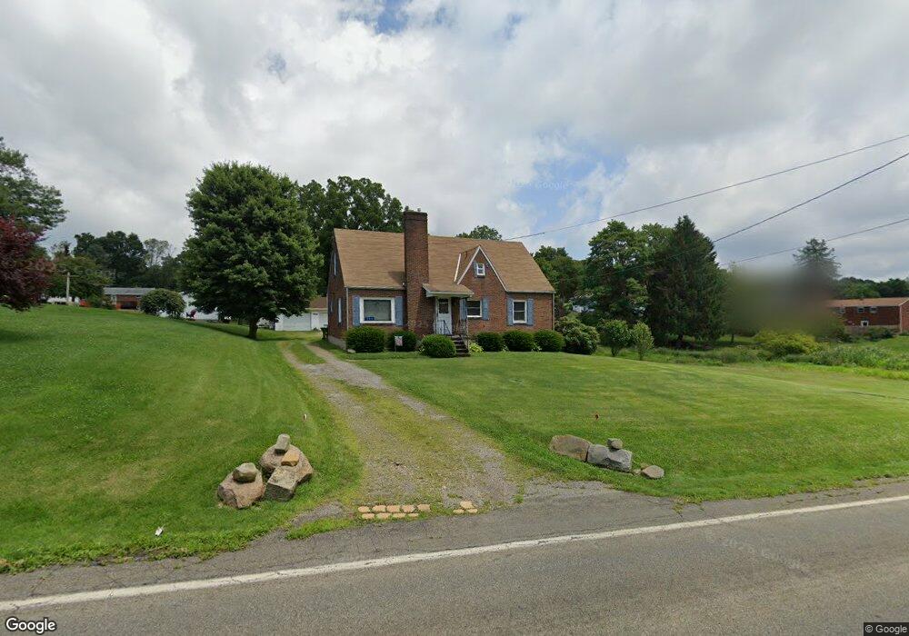
584 Whitestown Rd Butler, PA 16001
Butler NeighborhoodEstimated Value: $77,844 - $340,000
3
Beds
1
Bath
1,568
Sq Ft
$158/Sq Ft
Est. Value
About This Home
This home is located at 584 Whitestown Rd, Butler, PA 16001 and is currently estimated at $247,211, approximately $157 per square foot. 584 Whitestown Rd is a home located in Butler County with nearby schools including Butler Intermediate High School, Butler Middle School, and First Baptist Christian School.
Ownership History
Date
Name
Owned For
Owner Type
Purchase Details
Closed on
Jul 26, 2006
Sold by
Hartzell Justin D
Bought by
Springer Richard
Current Estimated Value
Purchase Details
Closed on
Sep 4, 2003
Sold by
Brown Paul
Bought by
Hartzell Justin
Home Financials for this Owner
Home Financials are based on the most recent Mortgage that was taken out on this home.
Original Mortgage
$134,893
Interest Rate
6.02%
Mortgage Type
New Conventional
Create a Home Valuation Report for This Property
The Home Valuation Report is an in-depth analysis detailing your home's value as well as a comparison with similar homes in the area
Home Values in the Area
Average Home Value in this Area
Purchase History
| Date | Buyer | Sale Price | Title Company |
|---|---|---|---|
| Springer Richard | $182,500 | -- | |
| Hartzell Justin | $136,000 | -- |
Source: Public Records
Mortgage History
| Date | Status | Borrower | Loan Amount |
|---|---|---|---|
| Previous Owner | Hartzell Justin | $134,893 |
Source: Public Records
Tax History Compared to Growth
Tax History
| Year | Tax Paid | Tax Assessment Tax Assessment Total Assessment is a certain percentage of the fair market value that is determined by local assessors to be the total taxable value of land and additions on the property. | Land | Improvement |
|---|---|---|---|---|
| 2025 | $2,350 | $15,820 | $2,190 | $13,630 |
| 2024 | $2,307 | $15,820 | $2,190 | $13,630 |
| 2023 | $2,261 | $15,820 | $2,190 | $13,630 |
| 2022 | $2,261 | $15,820 | $2,190 | $13,630 |
| 2021 | $2,261 | $15,820 | $0 | $0 |
| 2020 | $2,261 | $15,820 | $2,190 | $13,630 |
| 2019 | $2,213 | $15,820 | $2,190 | $13,630 |
| 2018 | $2,213 | $15,820 | $2,190 | $13,630 |
| 2017 | $2,162 | $15,820 | $2,190 | $13,630 |
| 2016 | $688 | $15,820 | $2,190 | $13,630 |
| 2015 | $321 | $15,820 | $2,190 | $13,630 |
| 2014 | $321 | $15,820 | $2,190 | $13,630 |
Source: Public Records
Map
Nearby Homes
- 594 Whitestown Rd
- 105 Lawrence Ave
- 219 Meridian Rd
- 500 Whitestown Rd
- 105 Reich Ave
- 100 Marion Dr
- 397 Evans City Rd
- 111 N Eberhart Rd
- 104 N Eberhart Rd
- 446 Eagle Mill Rd
- 4125 Loring St
- 1023 Springfield Ct
- 101 Napa Ct
- REGENT Plan at Autumn Woods
- CROFTON Plan at Autumn Woods
- 1404 Cherry Tree Dr
- 1402 Cherry Tree Dr
- 1401 Cherry Tree Dr
- 1403 Cherry Tree Dr
- Lot 10 Winterwood Dr
- 586 Whitestown Rd
- 589 Whitestown Rd
- 587 Whitestown Rd
- 588 Whitestown Rd
- 591 Whitestown Rd
- 583 Whitestown Rd
- 124 Lawrence Ave
- 580 Whitestown Rd
- 136 Lawrence Ave
- 593 Whitestown Rd
- 590 Whitestown Rd
- 126 Lawrence Ave
- 120 Lawrence Ave
- 118 Lawrence Ave
- 579 Whitestown Rd
- 592 Whitestown Rd
- 116 Lawrence Ave
- 595 Whitestown Rd
- 579 1/2 Whitestown Rd
- 578 Whitestown Rd