Estimated Value: $486,000 - $554,000
4
Beds
3
Baths
2,232
Sq Ft
$233/Sq Ft
Est. Value
About This Home
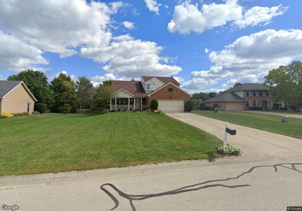
This home is located at 5842 Hassman Ct, Mason, OH 45040 and is currently estimated at $519,311, approximately $232 per square foot. 5842 Hassman Ct is a home located in Warren County with nearby schools including Mason Intermediate Elementary School, Mason Middle School, and William Mason High School.
Ownership History
Date
Name
Owned For
Owner Type
Purchase Details
Closed on
Apr 16, 2015
Sold by
Kauffman Arlin L and Kauffman Leslie
Bought by
Kauffman Arlin L and Kauffman Leslie A
Current Estimated Value
Purchase Details
Closed on
Jun 11, 1997
Sold by
Smith Ralph E
Bought by
Kauffman Arlin L and Kauffman Leslie
Home Financials for this Owner
Home Financials are based on the most recent Mortgage that was taken out on this home.
Original Mortgage
$117,000
Outstanding Balance
$16,053
Interest Rate
7.5%
Mortgage Type
New Conventional
Estimated Equity
$503,258
Purchase Details
Closed on
Jun 3, 1993
Sold by
Meyer Meyer and Meyer Douglas H
Bought by
Smith Smith and Smith Ralph E
Purchase Details
Closed on
Oct 29, 1992
Sold by
Schwarz Joseph W and Schwarz Magg
Bought by
Meyer and Meyer Douglas H
Purchase Details
Closed on
Jun 26, 1992
Sold by
Schwarz Joseph W and Schwarz Magg
Bought by
Schwarz and Schwarz Joseph W
Create a Home Valuation Report for This Property
The Home Valuation Report is an in-depth analysis detailing your home's value as well as a comparison with similar homes in the area
Home Values in the Area
Average Home Value in this Area
Purchase History
| Date | Buyer | Sale Price | Title Company |
|---|---|---|---|
| Kauffman Arlin L | -- | Attorney | |
| Kauffman Arlin L | $156,000 | -- | |
| Smith Smith | $138,000 | -- | |
| Meyer | $29,900 | -- | |
| Schwarz | -- | -- |
Source: Public Records
Mortgage History
| Date | Status | Borrower | Loan Amount |
|---|---|---|---|
| Open | Kauffman Arlin L | $117,000 |
Source: Public Records
Tax History Compared to Growth
Tax History
| Year | Tax Paid | Tax Assessment Tax Assessment Total Assessment is a certain percentage of the fair market value that is determined by local assessors to be the total taxable value of land and additions on the property. | Land | Improvement |
|---|---|---|---|---|
| 2024 | $5,298 | $130,540 | $38,500 | $92,040 |
| 2023 | $4,831 | $100,569 | $19,372 | $81,196 |
| 2022 | $4,769 | $100,569 | $19,373 | $81,197 |
| 2021 | $4,518 | $100,569 | $19,373 | $81,197 |
| 2020 | $4,284 | $81,764 | $15,750 | $66,014 |
| 2019 | $3,938 | $81,764 | $15,750 | $66,014 |
| 2018 | $3,951 | $81,764 | $15,750 | $66,014 |
| 2017 | $4,048 | $78,190 | $15,309 | $62,881 |
| 2016 | $4,169 | $78,190 | $15,309 | $62,881 |
| 2015 | $4,178 | $78,190 | $15,309 | $62,881 |
| 2014 | $4,074 | $71,080 | $13,920 | $57,170 |
| 2013 | $4,083 | $80,450 | $15,750 | $64,700 |
Source: Public Records
Map
Nearby Homes
- 7843 Butler Warren Rd
- 6955 Grand Oaks Ct
- 6070 Fireside Dr Unit 45
- 6356 Amber Ct Unit 91
- 7986 Tylers Way
- 6577 Rosegate Ct
- 6134 Nicholas Way
- 6142 Nicholas Way
- 5836 Bayswater Dr
- 5837 Southwater Dr Unit 205F
- 6260 Lake Front
- 6138 Nicholas Way
- 6387 Coverage Ct
- 6369 Coverage Ct
- 6403 Coverage Ct
- 6357 Coverage Ct
- 6383 Coverage Ct
- 6407 Coverage Ct
- 6375 Coverage Ct
- 6365 Coverage Ct
- 5824 Hassman Ct
- 5860 Hassman Ct
- 5857 Lisa Ct
- 5865 Lisa Ct
- 5806 Hassman Ct
- 5866 Hassman Ct
- 5839 Hassman Ct
- 5837 Lisa Ct
- 5821 Hassman Ct
- 5857 Hassman Ct
- 5863 Hassman Ct
- 5801 Hassman Ct
- 5817 Lisa Ct
- 5784 Hassman Ct
- 5871 Lisa Ct
- 5787 Hassman Ct
- 5797 Lisa Ct
- 5876 Butler Warren Rd
- 5768 Hassman Ct
- 5892 Butler Warren Rd