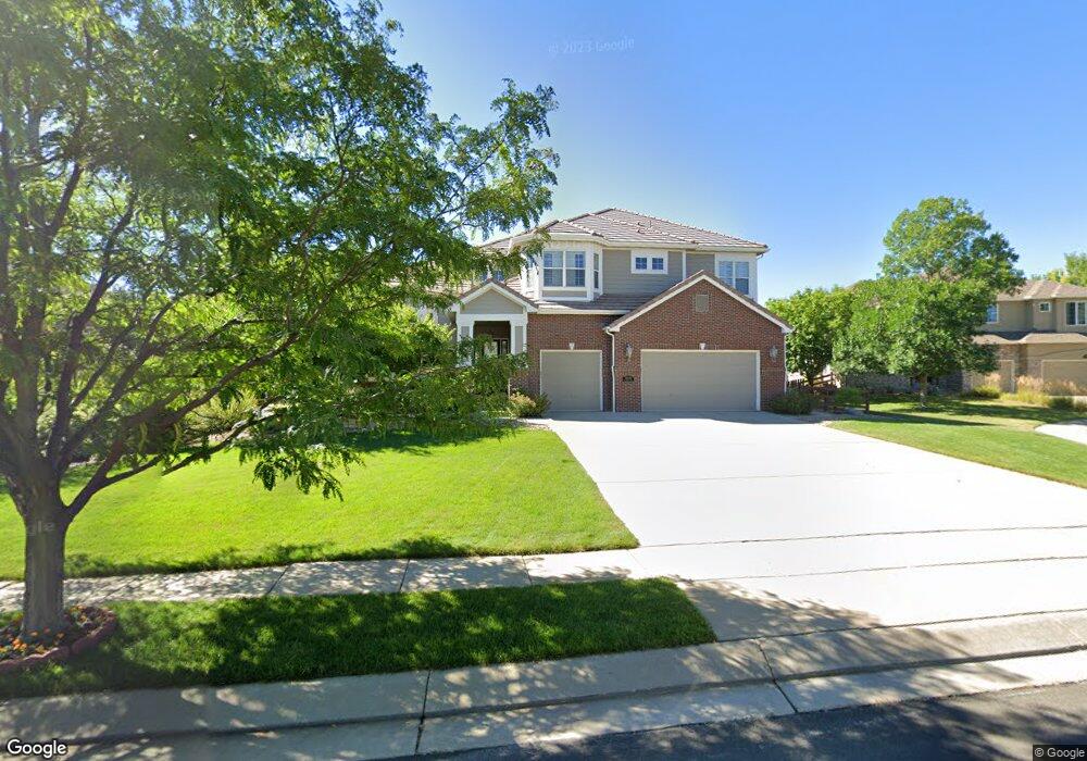
5848 Fox Ridge Ct Broomfield, CO 80020
Aspen Creek NeighborhoodEstimated Value: $1,280,844 - $1,525,000
5
Beds
5
Baths
4,076
Sq Ft
$339/Sq Ft
Est. Value
About This Home
This home is located at 5848 Fox Ridge Ct, Broomfield, CO 80020 and is currently estimated at $1,380,461, approximately $338 per square foot. 5848 Fox Ridge Ct is a home located in Broomfield County with nearby schools including Aspen Creek K-8 School, Broomfield High School, and Holy Family High School.
Ownership History
Date
Name
Owned For
Owner Type
Purchase Details
Closed on
Feb 28, 2003
Sold by
U S Home Corp
Bought by
Wobschall Steven Clark and Wobschall Tamara Gale
Current Estimated Value
Home Financials for this Owner
Home Financials are based on the most recent Mortgage that was taken out on this home.
Original Mortgage
$497,980
Outstanding Balance
$214,862
Interest Rate
5.93%
Estimated Equity
$1,165,599
Purchase Details
Closed on
Jul 5, 2001
Create a Home Valuation Report for This Property
The Home Valuation Report is an in-depth analysis detailing your home's value as well as a comparison with similar homes in the area
Home Values in the Area
Average Home Value in this Area
Purchase History
| Date | Buyer | Sale Price | Title Company |
|---|---|---|---|
| Wobschall Steven Clark | $626,359 | North American Title | |
| -- | $1,198,200 | -- |
Source: Public Records
Mortgage History
| Date | Status | Borrower | Loan Amount |
|---|---|---|---|
| Open | Wobschall Steven Clark | $497,980 |
Source: Public Records
Tax History Compared to Growth
Tax History
| Year | Tax Paid | Tax Assessment Tax Assessment Total Assessment is a certain percentage of the fair market value that is determined by local assessors to be the total taxable value of land and additions on the property. | Land | Improvement |
|---|---|---|---|---|
| 2025 | $7,734 | $85,500 | $18,090 | $67,410 |
| 2024 | $7,734 | $82,540 | $17,320 | $65,220 |
| 2023 | $7,719 | $89,440 | $18,770 | $70,670 |
| 2022 | $6,198 | $64,110 | $12,510 | $51,600 |
| 2021 | $6,167 | $65,960 | $12,870 | $53,090 |
| 2020 | $5,873 | $62,430 | $12,870 | $49,560 |
| 2019 | $5,862 | $62,870 | $12,960 | $49,910 |
| 2018 | $5,586 | $59,180 | $10,800 | $48,380 |
| 2017 | $5,501 | $65,430 | $11,940 | $53,490 |
| 2016 | $5,947 | $63,070 | $7,840 | $55,230 |
| 2015 | $5,742 | $53,660 | $7,840 | $45,820 |
| 2014 | $4,994 | $53,660 | $7,840 | $45,820 |
Source: Public Records
Map
Nearby Homes
- 13924 Quail Ridge Dr
- 13980 Willow Wood Dr
- 5704 W 141st Place
- Torrey Plan at Dillon Pointe
- Evans Plan at Dillon Pointe
- Antero Plan at Dillon Pointe
- 14111 Blue Stem St
- 14115 Blue Stem St
- 5625 W 141st Ln
- 5621 W 141st Ln
- 5632 W 142nd Ave
- 1757 Whistlepig Ln
- 5630 W 142nd Ave
- 5626 W 142nd Ave
- 5605 W 141st Ln
- 1747 Whistlepig Ln
- Antora Plan at Dillon Pointe - Dillon Pointe - Skyview
- Blanca Plan at Dillon Pointe - Dillon Pointe - Skyview
- Columbia Plan at Dillon Pointe - Dillon Pointe - Skyview
- Varra Plan at Dillon Pointe - Dillon Pointe - Journey
- 5828 Fox Ridge Ct
- 5968 Fox Ridge Ct
- 5915 Fox Hollow Dr
- 5865 Fox Hollow Dr
- 5925 Fox Hollow Dr
- 5857 Fox Ridge Ct
- 5808 Fox Ridge Ct
- 5988 Fox Ridge Ct
- 5837 Fox Ridge Ct
- 5977 Fox Ridge Ct
- 5955 Fox Hollow Dr
- 5805 Fox Hollow Dr
- 5987 Fox Ridge Ct
- 5817 Fox Ridge Ct
- 13964 Quail Ridge Dr
- 13958 Fox Hollow Ct
- 5874 Star View Dr
- 13984 Quail Ridge Dr
- 5854 Star View Dr
- 5934 Star View Dr