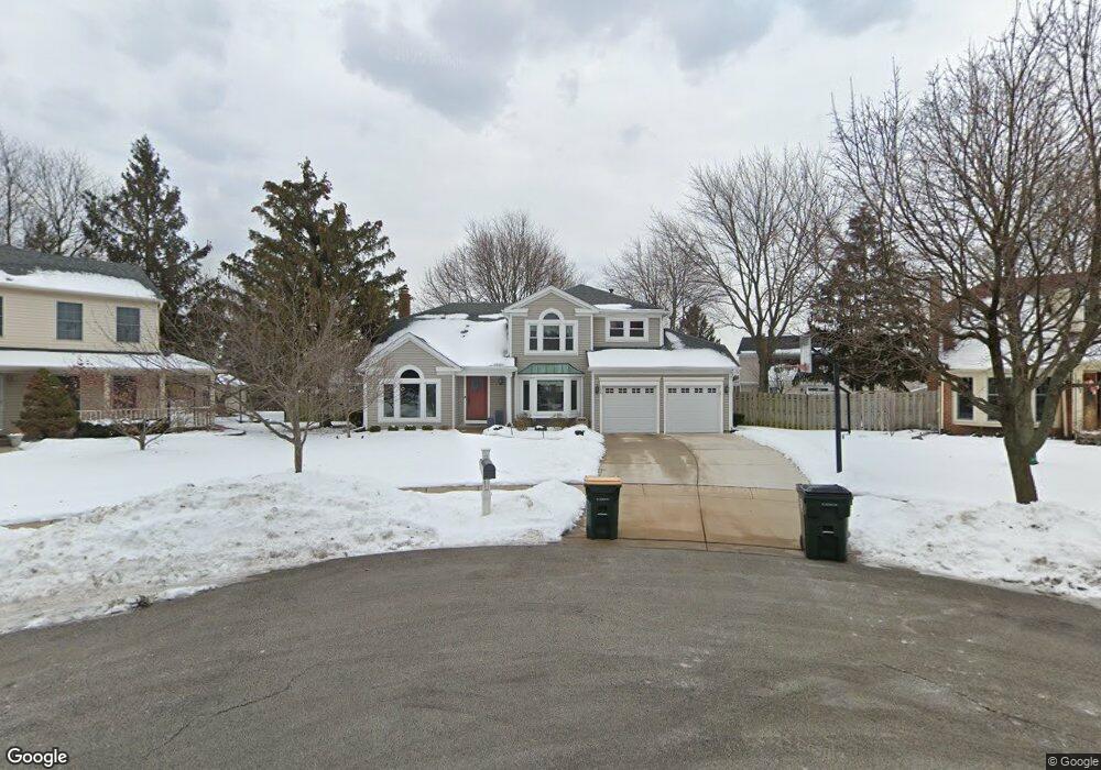
585 Oxford Cir Elk Grove Village, IL 60007
Elk Grove Village West NeighborhoodEstimated Value: $643,582 - $718,000
4
Beds
3
Baths
2,518
Sq Ft
$268/Sq Ft
Est. Value
About This Home
This home is located at 585 Oxford Cir, Elk Grove Village, IL 60007 and is currently estimated at $673,646, approximately $267 per square foot. 585 Oxford Cir is a home located in Cook County with nearby schools including Frederick Nerge Elementary School, Margaret Mead Junior High School, and J B Conant High School.
Ownership History
Date
Name
Owned For
Owner Type
Purchase Details
Closed on
Aug 29, 2007
Sold by
Howe Thomas C and Howe Joan M
Bought by
Kelly Robert J and Kelly Jolene M
Current Estimated Value
Home Financials for this Owner
Home Financials are based on the most recent Mortgage that was taken out on this home.
Original Mortgage
$402,000
Outstanding Balance
$256,469
Interest Rate
6.72%
Mortgage Type
Unknown
Estimated Equity
$417,177
Create a Home Valuation Report for This Property
The Home Valuation Report is an in-depth analysis detailing your home's value as well as a comparison with similar homes in the area
Home Values in the Area
Average Home Value in this Area
Purchase History
| Date | Buyer | Sale Price | Title Company |
|---|---|---|---|
| Kelly Robert J | $502,500 | Chicago Title Insurance Co |
Source: Public Records
Mortgage History
| Date | Status | Borrower | Loan Amount |
|---|---|---|---|
| Open | Kelly Robert J | $402,000 |
Source: Public Records
Tax History Compared to Growth
Tax History
| Year | Tax Paid | Tax Assessment Tax Assessment Total Assessment is a certain percentage of the fair market value that is determined by local assessors to be the total taxable value of land and additions on the property. | Land | Improvement |
|---|---|---|---|---|
| 2024 | $12,400 | $46,000 | $11,366 | $34,634 |
| 2023 | $12,025 | $46,000 | $11,366 | $34,634 |
| 2022 | $12,025 | $46,000 | $11,366 | $34,634 |
| 2021 | $11,512 | $39,506 | $7,431 | $32,075 |
| 2020 | $11,288 | $39,506 | $7,431 | $32,075 |
| 2019 | $11,299 | $43,896 | $7,431 | $36,465 |
| 2018 | $10,479 | $36,982 | $6,338 | $30,644 |
| 2017 | $10,384 | $36,982 | $6,338 | $30,644 |
| 2016 | $9,939 | $36,982 | $6,338 | $30,644 |
| 2015 | $10,740 | $37,276 | $5,245 | $32,031 |
| 2014 | $10,615 | $37,276 | $5,245 | $32,031 |
| 2013 | $10,324 | $37,276 | $5,245 | $32,031 |
Source: Public Records
Map
Nearby Homes
- 725 Bismark Ct
- 1845 Maryland Dr
- 924 Surrey Dr Unit 1A
- 833 Thornton Ct Unit 2B
- 826 Thornton Ct Unit 2AL
- 1810 Hawk Ln
- 409 New York Ln
- 1224 Knottingham Ct Unit 1A
- 932 Kentucky Ln
- 1124 Lovell Ct
- 1453 Armstrong Ln
- 718 N Point Dr
- 263 Doral Ct Unit 1
- 620 S Point Dr
- 1517 White Trail
- 722 Merlin Dr Unit 16
- 160 Inverness Ct Unit A
- 1022 Tennessee Ln
- 1385 Scarboro Rd Unit 204
- 1386 Scarboro Rd Unit 1102
- 583 Oxford Cir
- 1674 Biesterfield Rd
- 587 Oxford Cir
- 1682 Biesterfield Rd
- 1668 Biesterfield Rd
- 581 Oxford Cir
- 593 Jersey Ln
- 571 Rutgers Ln
- 570 Rutgers Ln
- 578 Jersey Ln
- 1706 Biesterfield Rd
- 565 Rutgers Ln
- 564 Rutgers Ln
- 568 Jersey Ln
- 1710 Biesterfield Rd
- 567 Jersey Ln
- 559 Rutgers Ln
- 558 Rutgers Ln
- 1703 Biesterfield Rd
- 564 Jersey Ln