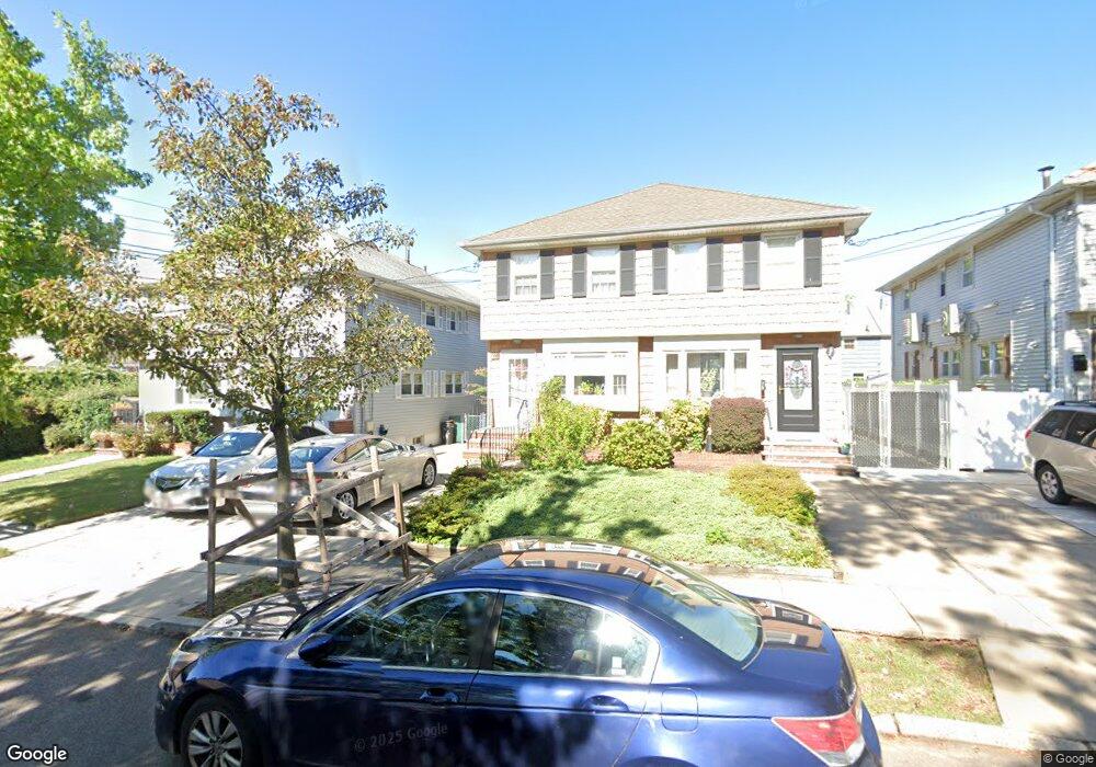
586 Hanover Ave Staten Island, NY 10304
Concord NeighborhoodEstimated Value: $583,914 - $724,000
--
Bed
4
Baths
1,230
Sq Ft
$549/Sq Ft
Est. Value
About This Home
This home is located at 586 Hanover Ave, Staten Island, NY 10304 and is currently estimated at $675,229, approximately $548 per square foot. 586 Hanover Ave is a home located in Richmond County with nearby schools including P.S. 48 - William C. Wilcox, I.S. 49 Berta A Dreyfus, and New Dorp High School.
Ownership History
Date
Name
Owned For
Owner Type
Purchase Details
Closed on
Jul 31, 2020
Sold by
Turner Margaret A and The James F Donahue Irrevocabl
Bought by
Turner Margaret A and The Margaret M Donahue Irrevocable Trust
Current Estimated Value
Purchase Details
Closed on
May 14, 2007
Sold by
Donahue James F and Donahue Margaret
Bought by
Turner Margaret A and The James F Donahue Irrevocable Trust
Create a Home Valuation Report for This Property
The Home Valuation Report is an in-depth analysis detailing your home's value as well as a comparison with similar homes in the area
Home Values in the Area
Average Home Value in this Area
Purchase History
| Date | Buyer | Sale Price | Title Company |
|---|---|---|---|
| Turner Margaret A | -- | None Available | |
| Turner Margaret A | -- | None Available |
Source: Public Records
Tax History Compared to Growth
Tax History
| Year | Tax Paid | Tax Assessment Tax Assessment Total Assessment is a certain percentage of the fair market value that is determined by local assessors to be the total taxable value of land and additions on the property. | Land | Improvement |
|---|---|---|---|---|
| 2025 | $4,902 | $37,860 | $6,264 | $31,596 |
| 2024 | $4,914 | $37,980 | $5,891 | $32,089 |
| 2023 | $4,676 | $27,302 | $5,274 | $22,028 |
| 2022 | $4,588 | $34,680 | $7,800 | $26,880 |
| 2021 | $4,691 | $36,540 | $7,800 | $28,740 |
| 2020 | $2,304 | $31,860 | $7,800 | $24,060 |
| 2019 | $4,105 | $32,340 | $7,800 | $24,540 |
| 2018 | $3,753 | $22,752 | $6,458 | $16,294 |
| 2017 | $4,048 | $22,752 | $7,623 | $15,129 |
| 2016 | $3,842 | $22,176 | $7,335 | $14,841 |
| 2015 | $3,282 | $21,115 | $6,282 | $14,833 |
| 2014 | $3,282 | $19,920 | $6,480 | $13,440 |
Source: Public Records
Map
Nearby Homes
- 72 Alan Loop
- 456 Oder Ave
- 1890 Clove Rd
- 31 Alan Loop Unit 65
- 24 Roosevelt St
- 164 Stonegate Dr
- 0 Douglas Rd
- 4 Sheridan Ave
- 63 Gateway Dr Unit 172
- 1 Neckar Ave
- 448 Neckar Ave
- 1 Douglas Ct
- 325 Oder Ave
- 13 Wilson Terrace
- 751 Targee St
- 315 Oder Ave
- 89 Columbus Ave
- 98 N Railroad Ave
- 174 Pierce St
- 190A Pierce St
- 588 Hanover Ave
- 584 Hanover Ave
- 582 Hanover Ave
- 590 Hanover Ave
- 580 Hanover Ave
- 576 Hanover Ave
- 585 Britton Ave
- 587 Britton Ave
- 583 Britton Ave
- 589 Britton Ave
- 581 Britton Ave
- 574 Hanover Ave
- 579 Britton Ave
- 572 Hanover Ave
- 579 Hanover Ave
- 601 Britton Ave
- 573 Britton Ave
- 581 Hanover Ave
- 583 Hanover Ave
- 609 Britton Ave