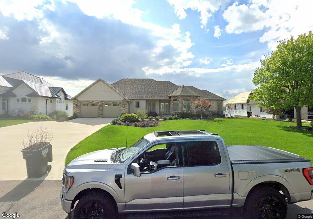
5869 16th Ave Hudsonville, MI 49426
Estimated Value: $815,464 - $988,000
4
Beds
4
Baths
3,900
Sq Ft
$231/Sq Ft
Est. Value
About This Home
This home is located at 5869 16th Ave, Hudsonville, MI 49426 and is currently estimated at $902,366, approximately $231 per square foot. 5869 16th Ave is a home located in Ottawa County with nearby schools including South Elementary School, Hudsonville Freshman Campus, and Riley Street Middle School.
Ownership History
Date
Name
Owned For
Owner Type
Purchase Details
Closed on
Nov 24, 2020
Sold by
Dorr Robert W and Vannatter Dorr Amy
Bought by
Dorr Robert W and Vannatter Dorr Amy
Current Estimated Value
Purchase Details
Closed on
Nov 24, 2003
Sold by
Miedema Pete and Miedema Phyllis
Bought by
Dorr Robert W and Vannatter Dorr Amy B
Home Financials for this Owner
Home Financials are based on the most recent Mortgage that was taken out on this home.
Original Mortgage
$90,000
Outstanding Balance
$36,224
Interest Rate
4.12%
Mortgage Type
Purchase Money Mortgage
Estimated Equity
$866,142
Create a Home Valuation Report for This Property
The Home Valuation Report is an in-depth analysis detailing your home's value as well as a comparison with similar homes in the area
Home Values in the Area
Average Home Value in this Area
Purchase History
| Date | Buyer | Sale Price | Title Company |
|---|---|---|---|
| Dorr Robert W | -- | None Available | |
| Dorr Robert W | $535,000 | -- |
Source: Public Records
Mortgage History
| Date | Status | Borrower | Loan Amount |
|---|---|---|---|
| Open | Dorr Robert W | $90,000 |
Source: Public Records
Tax History Compared to Growth
Tax History
| Year | Tax Paid | Tax Assessment Tax Assessment Total Assessment is a certain percentage of the fair market value that is determined by local assessors to be the total taxable value of land and additions on the property. | Land | Improvement |
|---|---|---|---|---|
| 2025 | $7,783 | $409,800 | $0 | $0 |
| 2024 | $6,735 | $375,900 | $0 | $0 |
| 2023 | $6,432 | $368,600 | $0 | $0 |
| 2022 | $7,019 | $340,100 | $0 | $0 |
| 2021 | $6,819 | $338,600 | $0 | $0 |
| 2020 | $6,748 | $323,900 | $0 | $0 |
| 2019 | $6,758 | $322,800 | $0 | $0 |
| 2018 | $6,300 | $316,600 | $0 | $0 |
| 2017 | $6,185 | $308,000 | $0 | $0 |
| 2016 | $6,150 | $285,000 | $0 | $0 |
| 2015 | $5,693 | $280,200 | $0 | $0 |
| 2014 | $5,693 | $213,800 | $0 | $0 |
Source: Public Records
Map
Nearby Homes
- Parcel 8 16th Ave
- 1496 Eagle Shore Ct Unit 13
- 1519 Eagle Shore Ct Unit Lot 33
- 1481 Eagle Shore Ct Unit 39
- 1451 Eagle Shore Ct
- 6025 Gleneagle Dr
- 1643 Laramy Ln
- 6129 W Bay Ct
- 1355 Bent Tree Dr Unit 12
- 6363 Eastridge Ct
- 1040 Castlebay Way Unit 19
- 1038 Castlebay Way Unit 18
- 1036 Castlebay Way Unit 17
- 5255 16th Ave
- 6028 22nd Ave
- 1025 Parsons St
- 1433 Winifred St
- 1361 Carol Dr
- 1306 Carol Dr
- 925 Parsons St SW