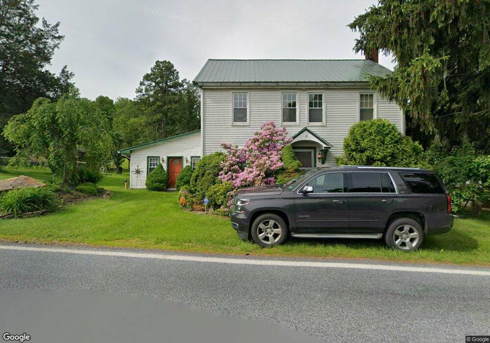
5881 Sweetwood Dr Macungie, PA 18062
Lower Macungie Township West NeighborhoodEstimated Value: $530,000 - $552,000
4
Beds
2
Baths
2,904
Sq Ft
$186/Sq Ft
Est. Value
About This Home
This home is located at 5881 Sweetwood Dr, Macungie, PA 18062 and is currently estimated at $539,730, approximately $185 per square foot. 5881 Sweetwood Dr is a home located in Lehigh County with nearby schools including Macungie Elementary School, Eyer Middle School, and Emmaus High School.
Ownership History
Date
Name
Owned For
Owner Type
Purchase Details
Closed on
Oct 8, 2025
Sold by
Keys Brian R and Keys Catherine A
Bought by
Keys Brian R
Current Estimated Value
Purchase Details
Closed on
Feb 5, 1999
Sold by
Keys Catherine A and Keys Brian R
Bought by
Keys Brian R and Keys Catherine A
Purchase Details
Closed on
Oct 15, 1996
Bought by
Hall Catherine A and Keys Brian R
Create a Home Valuation Report for This Property
The Home Valuation Report is an in-depth analysis detailing your home's value as well as a comparison with similar homes in the area
Home Values in the Area
Average Home Value in this Area
Purchase History
| Date | Buyer | Sale Price | Title Company |
|---|---|---|---|
| Keys Brian R | -- | None Listed On Document | |
| Keys Brian R | -- | -- | |
| Hall Catherine A | $145,000 | -- |
Source: Public Records
Tax History Compared to Growth
Tax History
| Year | Tax Paid | Tax Assessment Tax Assessment Total Assessment is a certain percentage of the fair market value that is determined by local assessors to be the total taxable value of land and additions on the property. | Land | Improvement |
|---|---|---|---|---|
| 2025 | $5,997 | $234,900 | $69,800 | $165,100 |
| 2024 | $5,732 | $234,900 | $69,800 | $165,100 |
| 2023 | $5,616 | $234,900 | $69,800 | $165,100 |
| 2022 | $5,481 | $234,900 | $165,100 | $69,800 |
| 2021 | $5,363 | $234,900 | $69,800 | $165,100 |
| 2020 | $5,311 | $234,900 | $69,800 | $165,100 |
| 2019 | $3,041 | $234,900 | $69,800 | $165,100 |
| 2018 | $5,143 | $234,900 | $69,800 | $165,100 |
| 2017 | $5,052 | $234,900 | $69,800 | $165,100 |
| 2016 | -- | $234,900 | $69,800 | $165,100 |
| 2015 | -- | $234,900 | $69,800 | $165,100 |
| 2014 | -- | $234,900 | $69,800 | $165,100 |
Source: Public Records
Map
Nearby Homes
- 830 E Main St
- 725 E Main St
- 211 S Church St
- Lot 1 Mountain Rd
- 0 Mountain Lot 1
- 167 Aspen Ln
- 6709 Mountain Rd
- 6405 Robin Rd
- 4759 Sheep Rock Rd
- 4245 Tank Farm Rd
- 3814 Clay Dr
- 6903 Lincoln Dr
- 0 Clauss Hunt Knight Dr Unit 10 Units 763578
- 4835 Shimerville Rd
- 5288 Brocton Ct
- 204 Ridings Cir Unit F204
- 5357 Bradford Ln Unit 173
- 5314 Beaumont Ln
- 4788 Buckeye Rd
- 353 Abby Rd Unit Lot 40
- 5931 Sweetwood Dr
- 177 Hillcrest Dr S
- 167 Hillcrest Dr S
- 6032 Sweetwood Dr
- 6030 Sweetwood Dr
- 157 Hillcrest Dr S
- 156 Hillcrest Dr S
- 6028 Sweetwood Dr
- 146 Hillcrest Dr S
- 147 Hillcrest Dr S
- 5970 Sweetwood Dr
- 101 S Chestnut St
- 136 Hillcrest Dr S
- 137 Hillcrest Dr S
- 126 Hillcrest Dr S
- 6076 Sweetwood Dr
- 133 S Fairview St
- 127 Hillcrest Dr S
- 123 S Fairview St
- 116 Hillcrest Dr S