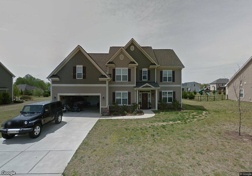
589 Adams Point Dr Garner, NC 27529
Cleveland NeighborhoodEstimated Value: $528,000 - $565,000
4
Beds
3
Baths
3,185
Sq Ft
$171/Sq Ft
Est. Value
About This Home
This home is located at 589 Adams Point Dr, Garner, NC 27529 and is currently estimated at $543,757, approximately $170 per square foot. 589 Adams Point Dr is a home located in Johnston County with nearby schools including West View Elementary School, Cleveland Middle School, and West Johnston High School.
Ownership History
Date
Name
Owned For
Owner Type
Purchase Details
Closed on
Aug 24, 2017
Sold by
Shedrick Clint and Shedrick Christy
Bought by
Ojha Anil and Ojha Trupti
Current Estimated Value
Home Financials for this Owner
Home Financials are based on the most recent Mortgage that was taken out on this home.
Original Mortgage
$265,500
Outstanding Balance
$221,956
Interest Rate
4.03%
Mortgage Type
New Conventional
Estimated Equity
$321,801
Create a Home Valuation Report for This Property
The Home Valuation Report is an in-depth analysis detailing your home's value as well as a comparison with similar homes in the area
Home Values in the Area
Average Home Value in this Area
Purchase History
| Date | Buyer | Sale Price | Title Company |
|---|---|---|---|
| Ojha Anil | $295,000 | None Available |
Source: Public Records
Mortgage History
| Date | Status | Borrower | Loan Amount |
|---|---|---|---|
| Open | Ojha Anil | $265,500 |
Source: Public Records
Tax History Compared to Growth
Tax History
| Year | Tax Paid | Tax Assessment Tax Assessment Total Assessment is a certain percentage of the fair market value that is determined by local assessors to be the total taxable value of land and additions on the property. | Land | Improvement |
|---|---|---|---|---|
| 2025 | $3,268 | $514,590 | $70,000 | $444,590 |
| 2024 | $2,698 | $333,130 | $48,000 | $285,130 |
| 2023 | $2,341 | $299,210 | $48,000 | $251,210 |
| 2022 | $2,461 | $299,210 | $48,000 | $251,210 |
| 2021 | $2,461 | $299,210 | $48,000 | $251,210 |
| 2020 | $2,491 | $299,210 | $48,000 | $251,210 |
| 2019 | $2,491 | $299,210 | $48,000 | $251,210 |
| 2018 | $2,352 | $275,880 | $44,000 | $231,880 |
| 2017 | $2,352 | $275,880 | $44,000 | $231,880 |
| 2016 | $2,388 | $275,880 | $44,000 | $231,880 |
| 2015 | $2,388 | $275,880 | $44,000 | $231,880 |
| 2014 | $2,385 | $275,880 | $44,000 | $231,880 |
Source: Public Records
Map
Nearby Homes
- 39 Beau Dr
- 36 Labradoodle Ct
- 394 Airedale Trail
- 413 Fieldtrial Cir
- 146 Shadowbark Dr
- 58 Larkwood Ln
- 115 Unique Place
- 1092 Adams Point Dr
- 1152 Black Angus Dr
- 75 Fawn Hill Ct
- 181 Fawn Hill Ct
- 165 Rynal Dr
- 1037 Olive Dr
- Roanoke Plan at Brant Station
- Fontana Plan at Brant Station
- Avenel II Plan at Brant Station
- 113 Hogan Dr
- 150 Sherrill Place Ln
- 111 Artic Cir
- 149 Presley Blvd
- 603 Adams Point Dr
- 577 Adams Point Dr
- 174 Sporting Club Dr Unit MELIS
- 174 Sporting Club Dr
- 164 Sporting Club Dr
- 613 Adams Point Dr
- 565 Adams Point Dr
- 598 Adams Point Dr
- 186 Sporting Club Dr Unit JADE
- 154 Sporting Club Dr Unit CAROL
- 154 Sporting Club Dr
- 586 Adams Point Dr
- 564 Adams Point Dr
- 574 Adams Point Dr
- 625 Adams Point Dr
- 198 Sporting Club Dr Unit HAMPT
- 198 Sporting Club Dr
- 551 Adams Point Dr
- 608 Adams Point Dr
- 144 Sporting Club Dr Unit KINGS