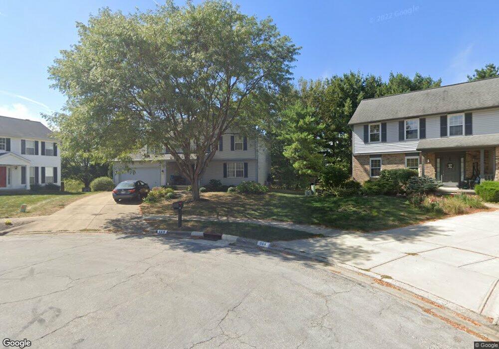
589 Locust Ct Westerville, OH 43082
Genoa NeighborhoodEstimated Value: $425,000 - $451,000
4
Beds
3
Baths
2,100
Sq Ft
$208/Sq Ft
Est. Value
About This Home
This home is located at 589 Locust Ct, Westerville, OH 43082 and is currently estimated at $435,940, approximately $207 per square foot. 589 Locust Ct is a home located in Delaware County with nearby schools including Robert Frost Elementary School, Heritage Middle School, and Westerville-North High School.
Ownership History
Date
Name
Owned For
Owner Type
Purchase Details
Closed on
Feb 23, 2016
Sold by
Kolman Marya C
Bought by
Kolman Marya C and Painter Dorothy S
Current Estimated Value
Purchase Details
Closed on
Dec 11, 2012
Sold by
Painter Dorothy S
Bought by
Kolman Marya C
Purchase Details
Closed on
Dec 23, 2008
Sold by
Cody Neal K and Cody Helenmary
Bought by
Painter Dorothy S
Purchase Details
Closed on
Aug 5, 1999
Sold by
Kaib Troy A
Bought by
Cody Neal K
Home Financials for this Owner
Home Financials are based on the most recent Mortgage that was taken out on this home.
Original Mortgage
$116,550
Interest Rate
7.68%
Mortgage Type
New Conventional
Create a Home Valuation Report for This Property
The Home Valuation Report is an in-depth analysis detailing your home's value as well as a comparison with similar homes in the area
Home Values in the Area
Average Home Value in this Area
Purchase History
| Date | Buyer | Sale Price | Title Company |
|---|---|---|---|
| Kolman Marya C | -- | None Available | |
| Kolman Marya C | $175,000 | None Available | |
| Painter Dorothy S | $142,500 | Attorney | |
| Cody Neal K | $145,700 | -- |
Source: Public Records
Mortgage History
| Date | Status | Borrower | Loan Amount |
|---|---|---|---|
| Previous Owner | Cody Neal K | $116,550 |
Source: Public Records
Tax History Compared to Growth
Tax History
| Year | Tax Paid | Tax Assessment Tax Assessment Total Assessment is a certain percentage of the fair market value that is determined by local assessors to be the total taxable value of land and additions on the property. | Land | Improvement |
|---|---|---|---|---|
| 2024 | $5,667 | $111,230 | $32,410 | $78,820 |
| 2023 | $5,602 | $111,230 | $32,410 | $78,820 |
| 2022 | $5,439 | $83,550 | $22,190 | $61,360 |
| 2021 | $5,486 | $83,550 | $22,190 | $61,360 |
| 2020 | $5,522 | $83,550 | $22,190 | $61,360 |
| 2019 | $4,786 | $69,170 | $19,290 | $49,880 |
| 2018 | $4,705 | $69,170 | $19,290 | $49,880 |
| 2017 | $4,593 | $64,230 | $14,040 | $50,190 |
| 2016 | $4,767 | $64,230 | $14,040 | $50,190 |
| 2015 | $4,559 | $64,230 | $14,040 | $50,190 |
| 2014 | $4,605 | $64,230 | $14,040 | $50,190 |
| 2013 | $4,404 | $61,400 | $14,040 | $47,360 |
Source: Public Records
Map
Nearby Homes
- 547 County Line Rd
- 718 Sugar Ct
- 200 Matthew Ave
- 150 Matthew Ave
- 175 Nottingham Ct
- 656 Olde Mill Dr
- 589 E College Ave
- 267 Windemere Place
- 368 E College Ave
- 364 E College Ave
- 912 Lakeway Ct E
- 223 Dogwood Ln
- 754 Kingsmead Rd Unit 18754
- 974 Lakeland Dr
- 768 Collingwood Dr
- 348 Buck Run Trail
- 192 Buckeye Ct
- 137 Abbeycross Ln
- 199 E College Ave
- 114 Canterbrick Dr
- 593 Locust Ct
- 586 Locust Ct
- 597 Locust Ct
- 590 Locust Ct
- 594 Locust Ct
- 603 Locust Ct
- 570 County Line Rd
- 600 Locust Ct
- 575 Mulberry Way S
- 609 Locust Ct
- 583 Mulberry Way S
- 610 County Line Rd
- 584 County Line Rd
- 589 Mulberry Way S
- 569 Mulberry Way S
- 576 County Line Rd
- 606 Locust Ct
- 597 Mulberry Way S
- 561 Mulberry Way S
- 289 Burns Dr N