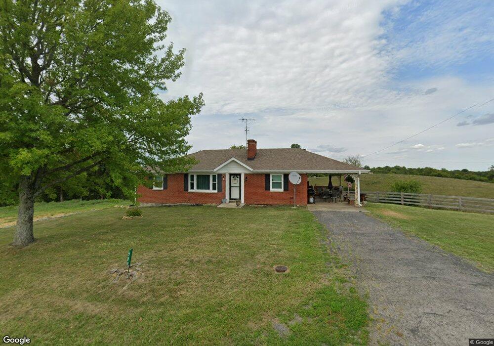
589 Martin Ln Harrodsburg, KY 40330
Estimated Value: $202,000 - $449,000
2
Beds
1
Bath
1,363
Sq Ft
$224/Sq Ft
Est. Value
About This Home
This home is located at 589 Martin Ln, Harrodsburg, KY 40330 and is currently estimated at $305,684, approximately $224 per square foot. 589 Martin Ln is a home located in Mercer County with nearby schools including Mercer County Elementary School, Mercer County Intermediate School, and King Middle School.
Ownership History
Date
Name
Owned For
Owner Type
Purchase Details
Closed on
Aug 31, 2022
Sold by
Logan Steele Phillip and Logan Sarah
Bought by
Storage4community Llc
Current Estimated Value
Purchase Details
Closed on
Apr 1, 2022
Sold by
Tony Best
Bought by
Steele Phillip L and Steele Sarah Gray
Home Financials for this Owner
Home Financials are based on the most recent Mortgage that was taken out on this home.
Original Mortgage
$160,000
Interest Rate
4.67%
Mortgage Type
New Conventional
Purchase Details
Closed on
May 11, 2007
Sold by
Best Addison
Bought by
Best Tony and Best Andrea C
Create a Home Valuation Report for This Property
The Home Valuation Report is an in-depth analysis detailing your home's value as well as a comparison with similar homes in the area
Home Values in the Area
Average Home Value in this Area
Purchase History
| Date | Buyer | Sale Price | Title Company |
|---|---|---|---|
| Storage4community Llc | $600,000 | -- | |
| Steele Phillip L | $400,000 | Bluegrass Land Title | |
| Best Tony | -- | -- |
Source: Public Records
Mortgage History
| Date | Status | Borrower | Loan Amount |
|---|---|---|---|
| Previous Owner | Steele Phillip L | $160,000 |
Source: Public Records
Tax History Compared to Growth
Tax History
| Year | Tax Paid | Tax Assessment Tax Assessment Total Assessment is a certain percentage of the fair market value that is determined by local assessors to be the total taxable value of land and additions on the property. | Land | Improvement |
|---|---|---|---|---|
| 2024 | $2,458 | $205,690 | $21,690 | $184,000 |
| 2023 | $2,481 | $205,690 | $0 | $0 |
| 2022 | $1,355 | $114,736 | $0 | $0 |
| 2021 | $1,076 | $90,495 | $0 | $0 |
| 2020 | $1,071 | $90,495 | $21,690 | $68,805 |
| 2019 | $1,088 | $90,495 | $21,690 | $68,805 |
| 2018 | $1,063 | $90,495 | $0 | $0 |
| 2017 | $1,027 | $90,495 | $0 | $0 |
| 2016 | $963 | $86,488 | $0 | $0 |
| 2015 | $937 | $86,488 | $17,683 | $68,805 |
| 2014 | $937 | $86,488 | $17,683 | $68,805 |
| 2010 | -- | $86,488 | $17,683 | $68,805 |
Source: Public Records
Map
Nearby Homes
- 986 Martin Ln
- 1100 Old Dixville Rd
- 1377 Harrodsburg Rd
- 2230 Perryville Rd
- 200 Nield Rd
- 9251 Old Danville Rd
- 9319 Old Danville Rd
- 324 Hays Mays Rd
- 8071 Perryville Rd
- 305 W 1st St
- 505 E 3rd St
- 309 E 3rd St
- 307 S Bragg St
- 512 S Bragg St
- TRACT 4- 7053 Perryville Rd
- 554 S Buell St
- 200 Rose Hill Ln
- 215 New Dixville Rd
- 41 Tuggle Rd
- 315 Devine Rd