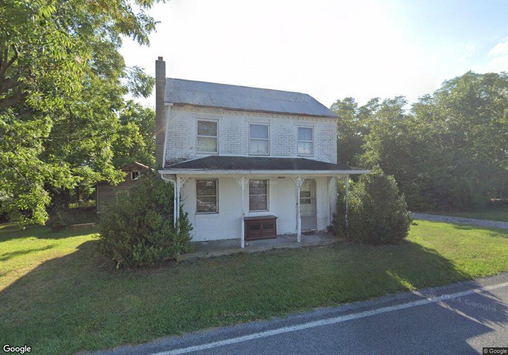
589 Mehring Rd Littlestown, PA 17340
Estimated Value: $286,000 - $490,000
4
Beds
1
Bath
1,514
Sq Ft
$263/Sq Ft
Est. Value
About This Home
This home is located at 589 Mehring Rd, Littlestown, PA 17340 and is currently estimated at $398,129, approximately $262 per square foot. 589 Mehring Rd is a home located in Adams County with nearby schools including Rolling Acres El School, Maple Avenue Middle School, and Littlestown Senior High School.
Ownership History
Date
Name
Owned For
Owner Type
Purchase Details
Closed on
Dec 15, 2022
Sold by
Aulthouse Samuel J and Aulthouse Esther M
Bought by
Aulthouse Rebecca R
Current Estimated Value
Purchase Details
Closed on
Mar 20, 2020
Sold by
Aulthouse Samuel J and Aulthouse Esther M
Bought by
Aulthouse Samuel J and Aulthouse Esther M
Purchase Details
Closed on
Jun 29, 2001
Bought by
Aulthouse Samuel J and Aulthouse Esther M
Create a Home Valuation Report for This Property
The Home Valuation Report is an in-depth analysis detailing your home's value as well as a comparison with similar homes in the area
Home Values in the Area
Average Home Value in this Area
Purchase History
| Date | Buyer | Sale Price | Title Company |
|---|---|---|---|
| Aulthouse Rebecca R | -- | -- | |
| Aulthouse Samuel J | -- | None Available | |
| Aulthouse Samuel J | $88,000 | -- |
Source: Public Records
Tax History Compared to Growth
Tax History
| Year | Tax Paid | Tax Assessment Tax Assessment Total Assessment is a certain percentage of the fair market value that is determined by local assessors to be the total taxable value of land and additions on the property. | Land | Improvement |
|---|---|---|---|---|
| 2025 | $2,673 | $141,200 | $7,800 | $133,400 |
| 2024 | $2,555 | $141,200 | $7,800 | $133,400 |
| 2023 | $5,207 | $141,200 | $7,800 | $133,400 |
| 2022 | $5,204 | $141,200 | $7,800 | $133,400 |
| 2021 | $5,021 | $141,200 | $7,800 | $133,400 |
| 2020 | $5,097 | $141,500 | $8,100 | $133,400 |
| 2019 | $4,988 | $141,500 | $8,100 | $133,400 |
| 2018 | $4,880 | $141,500 | $8,100 | $133,400 |
| 2017 | $2,205 | $141,500 | $8,100 | $133,400 |
| 2016 | -- | $141,500 | $8,100 | $133,400 |
| 2015 | -- | $140,800 | $7,400 | $133,400 |
| 2014 | -- | $140,200 | $6,800 | $133,400 |
Source: Public Records
Map
Nearby Homes
- LOT 9 Mehring Rd
- 1175 Bollinger Rd
- 567 Lumber St
- 559 Lumber St
- 535 Lumber St
- 43 Ashfield Dr Unit 14
- 1 Hickory Ln
- 241 M St
- 41 Smith Cir
- 61 E King St
- 106 E King St
- 22 Cemetery St
- 2100 Blacks School House Rd
- 128 Pine Grove Rd Unit 3
- 115 Charles St
- 117 Charles St
- 15 Yorktowne Ct Unit 97
- 162 Newark St
- 893 Georgetown Rd
- 22 Rita Marie Ave
- 590 Mehring Rd Unit 2
- 570 Mehring Rd Unit 1
- 610 Mehring Rd Unit 3
- 555 Mehring Rd Unit 2
- 30 Valleyview Dr Unit 10
- 35 Valleyview Dr Unit 22
- 525 Mehring Rd Unit 3
- 635 Mehring Rd
- 648 Mehring Rd Unit 5
- 515 Mehring Rd Unit 4
- 651 Mehring Rd
- 45 Valleyview Dr Unit 21
- 660 Mehring Rd
- 660 Kindig Rd
- 670 Mehring Rd
- 504 Mehring Rd Unit 2
- 15 Woodcrest Cir Unit 20
- 495 Mehring Rd Unit 6
- 25 Woodcrest Cir