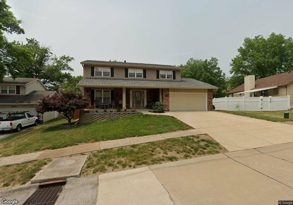
589 Summit View Dr Fenton, MO 63026
Estimated Value: $360,000 - $461,000
4
Beds
3
Baths
1,948
Sq Ft
$201/Sq Ft
Est. Value
About This Home
This home is located at 589 Summit View Dr, Fenton, MO 63026 and is currently estimated at $390,770, approximately $200 per square foot. 589 Summit View Dr is a home located in St. Louis County with nearby schools including Bowles Elementary School, Rockwood South Middle School, and Rockwood Summit Senior High School.
Ownership History
Date
Name
Owned For
Owner Type
Purchase Details
Closed on
Jun 19, 2001
Sold by
Mattler William Joseph and Mattler Gail Ann
Bought by
The William Joseph Mattler & Gail Ann Ma
Current Estimated Value
Purchase Details
Closed on
Jun 26, 1998
Sold by
Cox Peggy A
Bought by
Mattler William J and Mattler Gail A
Home Financials for this Owner
Home Financials are based on the most recent Mortgage that was taken out on this home.
Original Mortgage
$80,000
Outstanding Balance
$16,046
Interest Rate
7.08%
Estimated Equity
$374,724
Create a Home Valuation Report for This Property
The Home Valuation Report is an in-depth analysis detailing your home's value as well as a comparison with similar homes in the area
Purchase History
| Date | Buyer | Sale Price | Title Company |
|---|---|---|---|
| The William Joseph Mattler & Gail Ann Ma | -- | -- | |
| Mattler William J | -- | -- |
Source: Public Records
Mortgage History
| Date | Status | Borrower | Loan Amount |
|---|---|---|---|
| Open | Mattler William J | $80,000 |
Source: Public Records
Tax History
| Year | Tax Paid | Tax Assessment Tax Assessment Total Assessment is a certain percentage of the fair market value that is determined by local assessors to be the total taxable value of land and additions on the property. | Land | Improvement |
|---|---|---|---|---|
| 2025 | $4,256 | $64,340 | $24,000 | $40,340 |
| 2024 | $4,256 | $57,080 | $18,680 | $38,400 |
| 2023 | $4,252 | $57,080 | $18,680 | $38,400 |
| 2022 | $3,869 | $48,380 | $18,680 | $29,700 |
| 2021 | $3,840 | $48,380 | $18,680 | $29,700 |
| 2020 | $3,756 | $45,500 | $15,730 | $29,770 |
| 2019 | $3,767 | $45,500 | $15,730 | $29,770 |
| 2018 | $3,575 | $41,420 | $11,840 | $29,580 |
| 2016 | $3,030 | $35,690 | $9,940 | $25,750 |
Source: Public Records
Map
Nearby Homes
- 1230 Summit Meadows Dr
- 520 May Valley Dr
- 425 Roosevelt Woods Ct
- 818 Mary Lee Ct
- 975 Arlington Glen Dr
- 687 Green Forest Dr
- 711 Mosely Ct
- 1273 Green Falls Dr
- 811 Mary Lee Ct
- 87 Fall Meadow Ct
- 800 Mary Lee Ct
- 564 Oakwood Dr
- 000 Gravois Summit
- 1320 Fenton Hills Rd
- 740 Spring Crest Ct
- 708 Vanderville Dr
- 78 Poppy Dr Unit 78
- 729 Vanderville Dr
- 68 Rainbow Dr
- 1400 Flora Del Dr
- 593 Summit View Dr
- 581 Summit View Ct
- 597 Summit View Dr
- 584 Summit View Dr
- 588 Summit View Dr
- 577 Summit View Ct
- 561 Summit View Ct
- 568 Summit View Dr
- 596 Summit View Dr
- 565 Summit View Ct
- 592 Summit View Dr
- 569 Summit View Ct
- 573 Summit View Ct
- 1215 Summit Meadows Dr
- 560 Summit View Dr
- 1219 Summit Meadows Dr
- 1211 Summit Meadows Dr
- 557 Summit View Dr
- 1207 Summit Meadows Dr
- 557 May Valley Dr
Your Personal Tour Guide
Ask me questions while you tour the home.