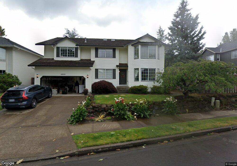
5893 Bay Point Dr Lake Oswego, OR 97035
Oak Creek NeighborhoodEstimated Value: $980,772 - $1,143,000
5
Beds
3
Baths
3,272
Sq Ft
$331/Sq Ft
Est. Value
About This Home
This home is located at 5893 Bay Point Dr, Lake Oswego, OR 97035 and is currently estimated at $1,083,943, approximately $331 per square foot. 5893 Bay Point Dr is a home located in Clackamas County with nearby schools including Oak Creek Elementary School, Lake Oswego Junior High School, and Lake Oswego Senior High School.
Ownership History
Date
Name
Owned For
Owner Type
Purchase Details
Closed on
Dec 24, 2002
Sold by
Silberberg Phillip J
Bought by
Harmon David A and Harmon Nobue N
Current Estimated Value
Home Financials for this Owner
Home Financials are based on the most recent Mortgage that was taken out on this home.
Original Mortgage
$264,000
Outstanding Balance
$109,275
Interest Rate
5.86%
Estimated Equity
$974,668
Purchase Details
Closed on
Jul 22, 2002
Sold by
Silberberg Jennifer
Bought by
Silberberg Phillip
Create a Home Valuation Report for This Property
The Home Valuation Report is an in-depth analysis detailing your home's value as well as a comparison with similar homes in the area
Home Values in the Area
Average Home Value in this Area
Purchase History
| Date | Buyer | Sale Price | Title Company |
|---|---|---|---|
| Harmon David A | $330,000 | Stewart Title | |
| Silberberg Phillip | -- | -- |
Source: Public Records
Mortgage History
| Date | Status | Borrower | Loan Amount |
|---|---|---|---|
| Open | Harmon David A | $264,000 |
Source: Public Records
Tax History Compared to Growth
Tax History
| Year | Tax Paid | Tax Assessment Tax Assessment Total Assessment is a certain percentage of the fair market value that is determined by local assessors to be the total taxable value of land and additions on the property. | Land | Improvement |
|---|---|---|---|---|
| 2025 | $9,720 | $506,150 | -- | -- |
| 2024 | $9,461 | $491,408 | -- | -- |
| 2023 | $9,461 | $477,096 | $0 | $0 |
| 2022 | $8,911 | $463,200 | $0 | $0 |
| 2021 | $8,230 | $449,709 | $0 | $0 |
| 2020 | $8,023 | $436,611 | $0 | $0 |
| 2019 | $7,826 | $423,895 | $0 | $0 |
| 2018 | $7,442 | $411,549 | $0 | $0 |
| 2017 | $7,181 | $399,562 | $0 | $0 |
| 2016 | $6,538 | $387,924 | $0 | $0 |
| 2015 | $6,316 | $376,625 | $0 | $0 |
| 2014 | $6,234 | $365,655 | $0 | $0 |
Source: Public Records
Map
Nearby Homes
- 13002 Sierra Vista Dr
- 12916 SW 61st Ave
- 5834 Ridgetop Ct
- 5437 Rosalia Way
- 5952 Sunbrook Dr
- 5530 Bay Creek Dr
- 61 Galen Rd
- 13541 SW 63rd Place
- 6045 SW Haines St
- 86 SW Kingsgate Unit 22
- 5093 Galen St
- 13070 Princeton Ct
- 4963 Suntree Ln
- 5094 Denton Dr
- 54 Cervantes Cir Unit 8F
- 6111 SW Lesser Way
- 304 Cervantes
- 11744 SW 61st Ave
- 4735 Amherst Ct
- 2 Nansen Summit
- 5907 Bay Point Dr
- 12884 Rogers Rd
- 12850 Rogers Rd
- 5856 Ridgetop Ct
- 5919 Bay Point Dr
- 5852 Ridgetop Ct
- 5896 Bay Point Dr
- 12926 Rogers Rd
- 5866 Ridgetop Ct
- 5844 Ridgetop Ct
- 5904 Bay Point Dr
- 5923 Bay Point Dr
- 5875 Bay Point Dr
- 12968 Rogers Rd
- 5876 Ridgetop Ct
- 12883 Sierra Ct
- 12872 Sierra Ct
- 5937 Bay Point Dr
- 5868 Bay Point Dr
- 5857 Ridgetop Ct